Royd House, Royd Lane, Far Royd, Halifax, HX3 6RX
About Royd House
Royd House is a detached house in Far Royd, Halifax, Halifax (HX3 6RX). It has a recorded floor area of 147 m² (around 1582 sq ft), construction records dating it to 1900-1929 and council tax band D. The latest certificate (December 2014) shows an E (score 45), well below the UK norm with real room to improve. The recommended improvements would lift it to C (score 76), a 2-band jump. The latest certificate is from December 2014, so improvements made since then won't be reflected.
Across 2017–2021, sale prices on this property compounded at 8.2% per year. Today's modelled estimate of £429,000 is 19.2% above the 2021 sale price. Last sale on file: £360,000 in May 2021. That sale was during the post-pandemic price surge, when transactions cleared materially above pre-2020 trend. One historical planning record sits against the property in 2011.
Everything you need to know about Royd House
The true value, the hidden risks and the full sale history, in one report.
Pick your report · every report is £14.99
One time fee only - money back guarantee

The data behind every report


Energy performance
Royd House's carbon output runs well above what efficient homes in the postcode produce.
EPC Expired
This certificate is over 10 years old and is no longer valid.Expired 04 Dec 2024
EPC Rating
Get a survey for this property
Level 3 Building Survey
Because the property was built before 1919, we believe a Level 3 building survey should be considered.
From £1,020 · Includes VAT
Planning history
1 application on record at Royd House, Royd Lane, Far Royd, Halifax, HX3 6RX
- Aug 2011FullOutcome in report
Replacement timber 'acoustic barrier' fence and replacement summer house
- Documents
- 17 docs on file
- Reference
- 11/00830/HSE
Unlock Royd House, Royd Lane, Far Royd, Halifax, HX3 6RX's full planning history
You're seeing the shape of it. The report has the substance.
- Every decision — granted, refused or withdrawn (1 on record)
- All 1 application on this property in full, plus 3 notable nearby
- The 17 documents, officer reports & conditions
- What the pattern means for extending or converting here
One time fee only - money back guarantee
Sales history & valuation
The latest sale landed in the post-pandemic price surge — useful context when reading the figure.
£429,000
Modelled from EPC, postcode comparables and a sale-price growth of 8.2% per year over 4 years.
£360,000
Growth on file: 8.2% per year over 4 years.
Sales timeline
9 May 2021Most recent
£360,000
+33.3%over 3 years14 September 2017
£270,000
Everything you need to know about Royd House
The true value, the hidden risks and the full sale history, in one report.
Pick your report · every report is £14.99
One time fee only - money back guarantee
The data behind every report
Similar properties nearby
1 Belgrave Park
HX3 6BB
1 Bellcross Drive
HX3 6AN
1 Belgrave Grove
HX3 6BD
1 Akroydon Court, Salisbury Place
HX3 6BT
1 Bradford Old Road
HX3 6UG
1 Belgrave Gardens
HX3 6BA
1 Beverley Place
HX3 6LR
1 Belgrave Close
HX3 6BH
The neighbourhood at a glance
Reported crime in the wider district is trending notably upward year-on-year.
Crime
3/mo
Rising year-on-year across the wider district.
Nearest stop
0.1 km
Shay Lane Churn Milk Ln — bus stop.
Closest school
0.5 km
Moorside Community Primary School. 27 schools nearby.
Go deeper on the local area
A Local Area report breaks down crime, transport links, schools and air quality in depth.
Road noise across the postcode
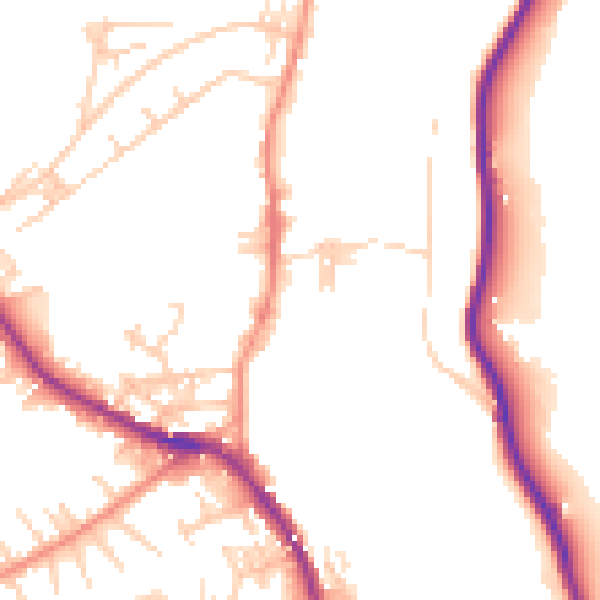
Daytime· 07:00 – 23:00
50.9dB

Night-time· 23:00 – 07:00
41.8dB