Skip to content

5 Ballroyd Road, Huddersfield, HD2 1AN

Property type
Mid terrace
Bedrooms
3
Floor area
66 m²
710 sq ft
Energy rating
D
Score 67
Council tax
Band A
Tenure
Owner Occupied
Overview

About 5 Ballroyd Road

A plain-English summary derived from public records, EPC certificates, sold prices and local data.

5 Ballroyd Road is a three-bedroom mid-terrace house in Huddersfield (HD2 1AN). It has a recorded floor area of 66 m² (around 710 sq ft), construction records dating it to 1900-1929 and council tax band A. The latest certificate (December 2017) shows a D (score 67), on the cusp of jumping into the C band. The recommended improvements would lift it to B (score 89), a 2-band jump.

Today's modelled estimate of £122,000 sits 121.8% above the 2019 sale of £55,000. Last sale on file: £55,000 in February 2019.

Specifications

What this property has

Pulled from EPC certificates, claim submissions and our property model. Empty categories are hidden — we only show what's known.

Inside

  • Bedrooms3

Building

  • Central heatingYes
Before you decide

Everything you need to know about 5 Ballroyd Road

The true value, the hidden risks and the full sale history, in one report.

Pick your report · every report is £14.99

One time fee only - money back guarantee

Preview of the full property report

The data behind every report

  • HM Land Registry, source of sold price history
  • Department for Education, source of schools data
  • Police.uk, source of crime statistics
  • Department for Transport, source of stations and transport links
  • Environment Agency, source of flood risk data
  • Department for Environment, Food & Rural Affairs, source of road noise data
  • PlanIt, source of planning application records
Energy

Energy performance

Every EPC certificate filed against this property — current rating, recorded improvements, and where there's headroom to reach a higher band.

Recommended upgrades on file would lift this property by multiple EPC bands.

EPC Rating

A
B
C
D
D67
E
F
G
Main Heating
Gas
Main Fuel
Gas
Hot Water
Good
Windows
Average
CO2 Emissions
2.9 t/year
Occupancy
Owner Occupied
SDL Surveying

Get a survey for this property

Level 3 Building Survey

Victorian-eraMid-Terrace HouseEPC DPre-1919 build

Because the property was built before 1919, we believe a Level 3 building survey should be considered.

From £820 · Includes VAT

Planning

Planning history

Applications and permits filed against 5 Ballroyd Road, Huddersfield, HD2 1AN, sourced from the PlanIt planning register.

5 Ballroyd Road has no planning applications on record.

1

But the area is active

1 notable application nearby — larger schemes and conversions that could reshape the street. The report maps them all.

Price

Sales history & valuation

Recorded transactions, our model's current estimate, and a quick read on what neighbouring properties have sold for.

5 Ballroyd Road valuation sits well clear of the typical sold price in this postcode.

Current estimate

£122,000

Modelled from EPC, postcode comparables.

See how we calculated this
Last sold (2019)

£55,000

Recorded with HM Land Registry.

Sales timeline

  1. 8 February 2019Most recent

    £55,000

Median price across the last 5 sales in HD2 1AN: £80,000 (2023–2021).

On the street

Versus other Ballroyd Road homes

Four headline reads against 31 similar houses on this street, drawn from the latest EPC and Land Registry data.

5 Ballroyd Road outperforms the street on habitable rooms by a wide margin.

Price per m²

£833

Street avg £918

On par

Floor Area

66 m²

Street avg 82 m²

Below

Habitable Rooms

5 rooms

Street avg 4 rooms

Above

CO₂ Emissions

2.9 t/year

Street avg 3.9 t/year

Above
Before you decide

Everything you need to know about 5 Ballroyd Road

The true value, the hidden risks and the full sale history, in one report.

Pick your report · every report is £14.99

One time fee only - money back guarantee

Preview of the full property report

The data behind every report

  • HM Land Registry, source of sold price history
  • Department for Education, source of schools data
  • Police.uk, source of crime statistics
  • Department for Transport, source of stations and transport links
  • Environment Agency, source of flood risk data
  • Department for Environment, Food & Rural Affairs, source of road noise data
  • PlanIt, source of planning application records
Area

The neighbourhood at a glance

A condensed read of the local area. Each tile links through to the full breakdown on the Huddersfield district page.

Reported crime in the wider district is trending notably upward year-on-year.

Crime

5/mo

Rising year-on-year across the wider district.

Nearest stop

0.1 km

Pollard Street — bus stop.

Closest school

0.6 km

North Huddersfield Trust School. 23 schools nearby.

Go deeper on the local area

A Local Area report breaks down crime, transport links, schools and air quality in depth.

Noise

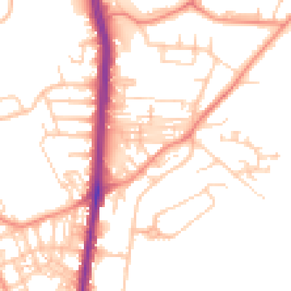
Road noise across the postcode

Modelled day and night-time noise levels around HD2 1AN from Defra's strategic mapping. The pin marks this postcode's centroid.
Daytime road noise heatmap for HD2 1AN

Daytime· 07:00 – 23:00

51.2dB

Low
Night-time road noise heatmap for HD2 1AN

Night-time· 23:00 – 07:00

40.1dB

Low
55 dB
60 dB
65 dB
70 dB
75 dB
80 dB
Defra Road Noise Strategic Mapping, Round 4
FAQ

Common questions

The questions buyers, sellers and homeowners most often ask about 5 Ballroyd Road, Huddersfield, HD2 1AN. Each answer is also embedded as structured data for search engines.