35 Derby Road, Enfield, EN3 4AJ
About 35 Derby Road
35 Derby Road is a detached house in Enfield (EN3 4AJ). It has a recorded floor area of 319 m² (around 3434 sq ft), construction records dating it to 1930-1949 and council tax band F. The latest certificate (March 2022) shows a C (score 70). The recommended improvements would push it to B (score 82).
At 319 m² the property is well over the postcode median (68 m² across 23 EPCs), placing it in the larger end of the local stock. Its energy rating outperforms most of the postcode (better than 74% of similar EPCs). 3 planning records sit against the property, 0 approved, 3 refused.
Everything you need to know about 35 Derby Road
The true value, the hidden risks and the full sale history, in one report.
30-day money-back guarantee

The data behind every report


Energy performance
35 Derby Road's carbon output runs well above what efficient homes in the postcode produce.
EPC Rating
Planning history
- Oct 2020HMOFullIn report
Change of use from a care home (C2) to a house of multiple occupation (HMO)(sui generis).
- Agent
- Advance Architecture
- Documents
- 12 docs on file
- Reference
- 20/02785/FUL
- Aug 2020HMOFullIn report
Change of use from a care home (C2) to a house of multiple occupation (HMO)(sui generis).
- Agent
- Advance Architecture
- Documents
- 11 docs on file
- Reference
- 20/02006/FUL
We flagged 1 thing worth checking at 35 Derby Road
Independent checks surfaced things a buyer would want to understand before offering. The report explains each one in full, with the underlying data and what to ask.
- Signs of HMO activity in the area
30-day money-back guarantee
Sales history & valuation
35 Derby Road has no Land Registry sales on file, suggesting it has stayed in the same hands since registration began.
£1,045,000
Modelled from EPC, postcode comparables.
No sales recorded with HM Land Registry
That can mean the property has never traded since the registry began publishing in 1995, was a new build that hasn't been registered yet, or is held in the same hands long-term.
Median price across the last 5 sales in EN3 4AJ: £400,000 (2024–2022).
Versus other Derby Road homes
35 Derby Road outperforms the street on epc rating by a wide margin.
EPC Rating
70 (C)
Street avg 55 (D)
Floor Area
319 m²
Street avg 99 m²
CO₂ Emissions
9.1 t/year
Street avg 5.4 t/year
Habitable Rooms
18 rooms
Street avg 5 rooms
Everything you need to know about 35 Derby Road
The true value, the hidden risks and the full sale history, in one report.
30-day money-back guarantee
The data behind every report
Similar properties nearby
The neighbourhood at a glance
Rail-style transport is unusually close for this postcode.
Crime
8/mo
Rising year-on-year across the wider district.
Nearest stop
0.2 km
Lincoln Road Ponders End — bus stop.
Closest school
0.1 km
Heron Hall Academy. 46 schools nearby.
Go deeper on the local area
The full report breaks down crime, transport links, schools and air quality in depth.
Road noise across the postcode
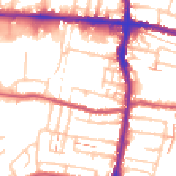
Daytime· 07:00 – 23:00
54.1dB

Night-time· 23:00 – 07:00
43.6dB