49 Kedleston Walk, Tower Hamlets, London, E2 9RP
About 49 Kedleston Walk
49 Kedleston Walk is a four-bedroom mid-terrace house in Tower Hamlets, London, London (E2 9RP). It has a recorded floor area of 99 m² (around 1066 sq ft), construction records dating it to 1967-1975 and council tax band C. The latest certificate (November 2020) shows a D (score 62), on the cusp of jumping into the C band. Earlier certificates rated it C (November 2008); the latest reading is one band lower. Between certificates, lighting went from Very Poor to Very Good; while wall efficiency dropped from Good to Poor and roof efficiency dropped from Average to Very Poor. The recommended improvements would push it to C (score 72). Other recorded features include a balcony. Our model identifies extension potential, subject to local planning policy.
At 99 m² the property is well over the postcode median (72 m² across 41 EPCs), placing it in the larger end of the local stock. Across 2008–2023, sale prices on this property compounded at 4.1% per year. Today's modelled estimate of £752,000 is 13.9% above the 2023 sale price. On a £-per-square-foot basis, the last sale (£619/sq ft) was about 74% above the typical sold price in the postcode. Last sale on file: £660,000 in September 2023.
Know exactly what you're buying at 49 Kedleston Walk
Before you offer, see what the listing won't tell you, the true value, the red flags and the full history.
Already flagged here
Valuation
against the asking price
Risks
planning & flood
Sold prices
similar homes nearby
Trends
the local market
What this property has
Inside
- Bedrooms4
- Bathrooms1
Outside
- BalconyYes
Building
- Extension potentialPossible
Energy performance
EPC Rating
Property Improvements
Changes detected from historical EPC data
Hot water efficiency decreased
More low energy lighting installed
Heating controls upgraded for better temperature management
Hot water efficiency decreased
Planning history
49 Kedleston Walk has no planning applications on record.
Notable planning nearby
2applications of note in the surrounding area
We flagged 1 thing worth checking at 49 Kedleston Walk
Independent checks surfaced things a buyer would want to understand before offering. The report explains each one in full, with the underlying data and what to ask.
- Larger development activity nearby
30-day money-back guarantee
Sales history & valuation
49 Kedleston Walk valuation sits well clear of the typical sold price in this postcode.
£752,000
Modelled from EPC, postcode comparables and a sale-price growth of 4.1% per year over 16 years.
£660,000
Growth on file: 4.1% per year over 16 years.
Sales timeline
18 September 2023Most recent
£660,000
+88.6%over 15 years24 January 2008
£349,999
Median price across the last 5 sales in E2 9RP: £585,000 (2025–2023).
Nearby sales in E2 9RP
9 Kedleston Walk, Tower Hamlets, London, E2 9RP
Sold Mar 2025
£585,00013 Kedleston Walk, Tower Hamlets, London, E2 9RP
Sold Sept 2024
£585,0001 Kedleston Walk, Tower Hamlets, London, E2 9RP
Sold Jun 2024
£560,00017 Kedleston Walk, Tower Hamlets, London, E2 9RP
Sold Sept 2023
£480,0003 Kedleston Walk, Tower Hamlets, London, E2 9RP
Sold Aug 2023
£625,000
Everything we know about 49 Kedleston Walk, in one report
What it's really worth, what could be wrong, and the planning, sales and area data in full.
What we flagged
- Larger development activity nearby

Versus other Kedleston Walk homes
On co₂ emissions, 49 Kedleston Walk runs well behind the street norm.
Price per m²
£6,667
Street avg £5,536
Floor Area
99 m²
Street avg 69 m²
Habitable Rooms
5 rooms
Street avg 3 rooms
CO₂ Emissions
4.1 t/year
Street avg 2.5 t/year
Similar properties nearby
1 Ponsonby Villas, Wadeson Street, Tower Hamlets
E2 9DF
1 The Terraces, Garner Street, Tower Hamlets
E2 9AQ
1 Kedleston Walk, Tower Hamlets
E2 9RP
1 Russia Lane, Tower Hamlets
E2 9BX
1 Esker Place, Tower Hamlets
E2 9FD
1 Silk Weaver Way, Tower Hamlets
E2 9BS
1 Robinson Road, Tower Hamlets
E2 9LX
1 Glacier Place, Tower Hamlets
E2 9FE
The neighbourhood at a glance
Rail-style transport is unusually close for this postcode.
Crime
11/mo
Falling year-on-year across the wider district.
Nearest stop
0.2 km
Old Ford Road (E2) — bus stop.
Closest school
0.3 km
St John's Church of England Primary School. 111 schools nearby.
Go deeper on the local area
The full report breaks down crime, transport links, schools and air quality in depth.
Road noise across the postcode
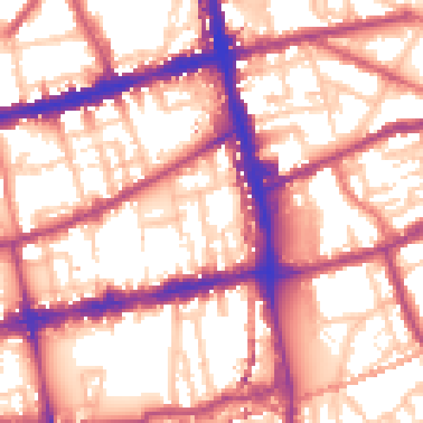
Daytime· 07:00 – 23:00
58.2dB
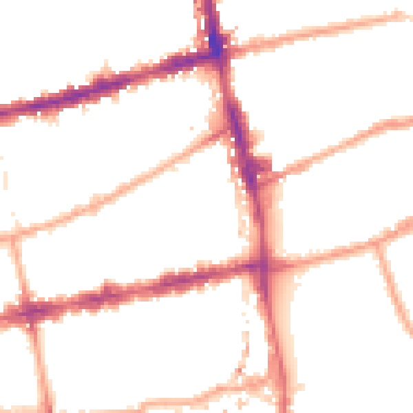
Night-time· 23:00 – 07:00
48.5dB