Shaftesbury Point, Flat 41, High Street, Newham, London, E13 0AB
About Shaftesbury Point
Shaftesbury Point is a mid-terrace house in Newham, London, London (E13 0AB). It has a recorded floor area of 45 m² (around 484 sq ft), construction records dating it to 1967-1975 and council tax band A. At 45 m² this is the smallest unit on EPC record across Shaftesbury Point (45–59 m²). The building's EPC ratings span D to C, with this unit at the top. The latest certificate (June 2023) shows a C (score 74).
Held since April 1997 — that's 29 years off the open market, well above the local norm. Only one transfer is on record with HM Land Registry, suggesting it has stayed in the same hands for a long time. Today's modelled estimate of £206,000 sits 795.7% above the 1997 sale of £23,000. On a £-per-square-foot basis, the last sale (£47/sq ft) was about 72.7% below the postcode norm. One historical planning record sits against the property in 2022.
Know exactly what you're buying at Shaftesbury Point
Before you offer, see what the listing won't tell you, the true value, the red flags and the full history.
Already flagged here
Valuation
against the asking price
Risks
planning & flood
Sold prices
similar homes nearby
Trends
the local market
Energy performance
Shaftesbury Point's carbon output is low for the local stock.
EPC Rating
Planning history
- Jul 2022OutlineIn report
Use of room for administration/radio control for taxi business (no customers or visitors to the application site).
- Documents
- 6 docs on file
- Reference
- 22/01586/CLP
We flagged 1 thing worth checking at Shaftesbury Point
Independent checks surfaced things a buyer would want to understand before offering. The report explains each one in full, with the underlying data and what to ask.
- Signs of HMO activity in the area
30-day money-back guarantee
Sales history & valuation
Latest sale on Shaftesbury Point was the lowest on Land Registry record across the postcode.
£206,000
Modelled from EPC, postcode comparables.
£23,000
Recorded with HM Land Registry.
Sales timeline
21 April 1997Most recent
£23,000
Median price across the last 5 sales in E13 0AB: £140,000 (2024–2013).
Nearby sales in E13 0AB
Shaftesbury Point, Flat 7, High Street, Newham, London, E13 0AB
Sold Jul 2024
£225,000Shaftesbury Point, Flat 42, High Street, Newham, London, E13 0AB
Sold Dec 2017
£175,000Shaftesbury Point, Flat 11, High Street, Newham, London, E13 0AB
Sold Jul 2013
£90,000Shaftesbury Point, Flat 49, High Street, Newham, London, E13 0AB
Sold Sept 2007
£100,000Shaftesbury Point, Flat 14, High Street, Newham, London, E13 0AB
Sold Oct 2002
£85,000
Everything we know about Shaftesbury Point, in one report
What it's really worth, what could be wrong, and the planning, sales and area data in full.
What we flagged
- Signs of HMO activity in the area

Versus other High Street homes
On price per m², Shaftesbury Point runs well behind the street norm.
Price per m²
£511
Street avg £2,992
Floor Area
45 m²
Street avg 46 m²
Habitable Rooms
3 rooms
Street avg 2 rooms
CO₂ Emissions
1.4 t/year
Street avg 1.4 t/year
Similar properties nearby
2a, Flat 7, Dundee Road, Newham
E13 0BQ
2a, Flat 8, Dundee Road, Newham
E13 0BQ
128 148, Flat 11, High Street, Newham
E13 0AP
2a, Flat 11, Dundee Road, Newham
E13 0BQ
128 148, Flat 10, High Street, Newham
E13 0AP
215a, Flat 1, Plashet Road, Newham
E13 0QU
230d, Flat 3, Grange Road, Newham
E13 0HB
2a, Flat 6, Dundee Road, Newham
E13 0BQ
The neighbourhood at a glance
Rail-style transport is unusually close for this postcode.
Crime
7/mo
Rising year-on-year across the wider district.
Nearest stop
0.1 km
Balaam Street Plaistow — bus stop.
Closest school
0.3 km
Curwen Primary School. 90 schools nearby.
Go deeper on the local area
The full report breaks down crime, transport links, schools and air quality in depth.
Road noise across the postcode
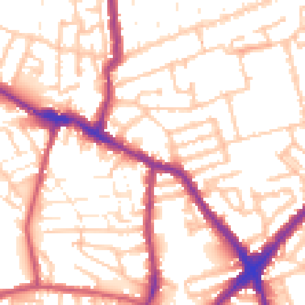
Daytime· 07:00 – 23:00
54.3dB
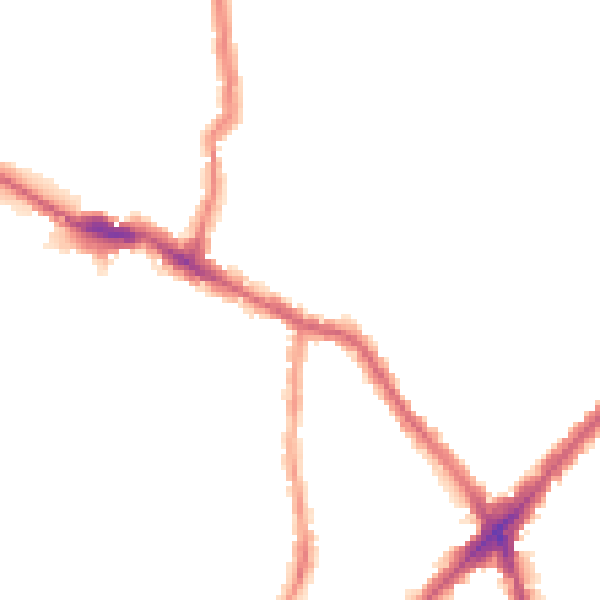
Night-time· 23:00 – 07:00
43.9dB