21 Berney Road, Croydon, CR0 2JX
About 21 Berney Road
21 Berney Road is a detached house in Croydon (CR0 2JX). It has a recorded floor area of 53 m² (around 574 sq ft), construction records dating it to 1967-1975 and council tax band B. At 53 m² this is the 2nd smallest of 23 units on EPC record in the building, where floor areas span 40–141 m². The building's EPC ratings span E to B across 23 units on file. The latest certificate (October 2008) shows a C (score 74). The latest certificate is from October 2008, so improvements made since then won't be reflected.
At 53 m² it's 26% smaller than the typical home in the postcode (72 m² median across 22 EPCs).
Everything you need to know about 21 Berney Road
The true value, the hidden risks and the full sale history, in one report.
30-day money-back guarantee

The data behind every report


Energy performance
21 Berney Road's EPC is over a decade old — improvements since won't be reflected.
EPC Expired
This certificate is over 10 years old and is no longer valid.Expired 31 Oct 2018
EPC Rating
Planning history
21 Berney Road has no planning applications on record.
Notable planning nearby
64applications of note in the surrounding area
We flagged 2 things worth checking at 21 Berney Road
Independent checks surfaced things a buyer would want to understand before offering. The report explains each one in full, with the underlying data and what to ask.
- Signs of HMO activity in the area
- Larger development activity nearby
30-day money-back guarantee
Sales history & valuation
21 Berney Road has no Land Registry sales on file, suggesting it has stayed in the same hands since registration began.
£211,000
Modelled from EPC, postcode comparables.
No sales recorded with HM Land Registry
That can mean the property has never traded since the registry began publishing in 1995, was a new build that hasn't been registered yet, or is held in the same hands long-term.
Median price across the last 5 sales in CR0 2JX: £285,000 (2025–2014).
Versus other Berney Road homes
Floor Area for 21 Berney Road lags the street by a wide margin.
EPC Rating
74 (C)
Street avg 73 (C)
Floor Area
53 m²
Street avg 70 m²
CO₂ Emissions
2.2 t/year
Street avg 2.2 t/year
Habitable Rooms
3 rooms
Street avg 3 rooms
Everything you need to know about 21 Berney Road
The true value, the hidden risks and the full sale history, in one report.
30-day money-back guarantee
The data behind every report
Similar properties nearby
The neighbourhood at a glance
Rail-style transport is unusually close for this postcode.
Crime
6/mo
Steady year-on-year across the wider district.
Nearest stop
0.2 km
Cromwell Road (CR0) — bus stop.
Closest school
0.5 km
Broadmead Primary School. 57 schools nearby.
Go deeper on the local area
The full report breaks down crime, transport links, schools and air quality in depth.
Road noise across the postcode
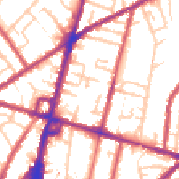
Daytime· 07:00 – 23:00
54.7dB
Night-time· 23:00 – 07:00
45.3dB