Darwin Cottage, The Heath, Hatfield Heath, Bishop's Stortford, CM22 7EB
About Darwin Cottage
Darwin Cottage is a property in Bishop's Stortford (CM22 7EB). It has council tax band D.
One historical planning record sits against the property in 2013.
Energy performance
No EPC on record
This property doesn't have an Energy Performance Certificate yet. An EPC is required to sell or let — and unlocks our automated valuation.
Planning history
- Jan 2013Change Of UseFullIn report
Change of use of two rooms from residential to business use as an office and minor surgical procedures room for veterinary purposes
- Documents
- 13 docs on file
- Reference
- UTT/12/6062/FUL
Sales history & valuation
No sales recorded with HM Land Registry
That can mean the property has never traded since the registry began publishing in 1995, was a new build that hasn't been registered yet, or is held in the same hands long-term.
Median price across the last 5 sales in CM22 7EB: £287,000 (2022–2016).
Nearby sales in CM22 7EB
The Chestnuts, The Heath, Hatfield Heath, Bishop's Stortford, CM22 7EB
Sold Nov 2022
£500,000Primley, The Heath, Hatfield Heath, Bishop's Stortford, CM22 7EB
Sold Aug 2019
£287,000Stonedash, The Heath, Hatfield Heath, Bishop's Stortford, CM22 7EB
Sold Jul 2018
£553,000Highview, Flat 1, The Heath, Hatfield Heath, Bishop's Stortford, CM22 7EB
Sold Nov 2016
£232,000Highview, Flat 2, The Heath, Hatfield Heath, Bishop's Stortford, CM22 7EB
Sold Mar 2016
£199,995
Similar properties nearby
1 Abbess Cottage, The Heath, Hatfield Heath
CM22 7EA
1 Almshouses, High Street, Hatfield Broad Oak
CM22 7HF
1 Ardley Crescent, Hatfield Heath
CM22 7AH
1 Barkers Mead, Little Hallingbury
CM22 7SN
1 Barley Close, Hatfield Heath
CM22 7DB
1 Barnfield, Hatfield Broad Oak
CM22 7JR
1 Barrington Cottages, Dunmow Road, Hatfield Broad Oak
CM22 7JH
1 Barrington Hall Cottages, Hatfield Broad Oak
CM22 7LA
The neighbourhood at a glance
Daytime road noise here sits well below conversation level — a quiet pocket of the postcode.
Crime
2/mo
Steady year-on-year across the wider district.
Nearest stop
0.0 km
The White Horse — bus stop.
Closest school
0.2 km
Hatfield Heath Primary School. 3 schools nearby.
Road noise across the postcode
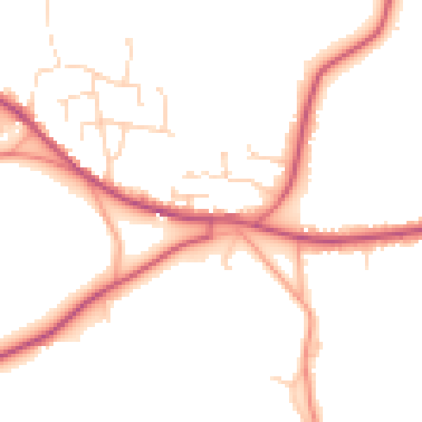
Daytime· 07:00 – 23:00
48.3dB

Night-time· 23:00 – 07:00
40.7dB