35 Belmont Drive, Wirral, CH61 9NA
About 35 Belmont Drive
35 Belmont Drive is a three-bedroom semi-detached house in Wirral (CH61 9NA). It has a recorded floor area of 98 m² (around 1055 sq ft), construction records dating it to 1930-1949 and council tax band C. The latest certificate (December 2019) shows a D (score 65), on the cusp of jumping into the C band. The recommended improvements would lift it to B (score 85), a 2-band jump. Period features are noted in the property record.
Across 2006–2022, sale prices on this property compounded at 4% per year. Today's modelled estimate of £326,000 is 10.5% above the 2022 sale price. On a £-per-square-foot basis, the last sale (£280/sq ft) was about 79.2% above the typical sold price in the postcode. Most recent transfer: June 2022 at £295,000. That sale was during the post-pandemic price surge, when transactions cleared materially above pre-2020 trend.
What this property has
Inside
- Bedrooms3
- Bathrooms1
- Dining roomYes
Outside
- Private gardenYes
Building
- Heating systemGas
- Period featuresYes
- RefurbishedYes
Everything you need to know about 35 Belmont Drive
The true value, the hidden risks and the full sale history, in one report.
30-day money-back guarantee

The data behind every report


Energy performance
Recommended upgrades on file would lift this property by multiple EPC bands.
EPC Rating
Planning history
35 Belmont Drive has no planning applications on record.
The full report still covers planning activity across the surrounding area.
Sales history & valuation
The latest sale landed in the post-pandemic price surge — useful context when reading the figure.
£326,000
Modelled from EPC, postcode comparables and a sale-price growth of 4.0% per year over 16 years.
£295,000
Growth on file: 4.0% per year over 16 years.
Sales timeline
23 June 2022Most recent
£295,000
+84.4%over 15 years12 September 2006
£160,000
Median price across the last 5 sales in CH61 9NA: £313,000 (2023–2021).
Nearby sales in CH61 9NA
Versus other Belmont Drive homes
35 Belmont Drive outperforms the street on price per m² by a wide margin.
Price per m²
£3,010
Street avg £2,179
Floor Area
98 m²
Street avg 113 m²
Habitable Rooms
5 rooms
Street avg 6 rooms
CO₂ Emissions
4.2 t/year
Street avg 5.0 t/year
Everything you need to know about 35 Belmont Drive
The true value, the hidden risks and the full sale history, in one report.
30-day money-back guarantee
The data behind every report
Similar properties nearby
1 Fender Way
CH61 9NP
1 Kings Drive, Thingwall
CH61 9PX
1 Beech Avenue, Pensby
CH61 9NU
1 Cestrian Drive
CH61 9PL
1 Belmont Drive
CH61 9NA
10 Bentley Road
CH61 9QB
1 Laurelhurst Avenue
CH61 9NY
10 Beech Avenue, Pensby
CH61 9NU
The neighbourhood at a glance
Daytime road noise here sits well below conversation level — a quiet pocket of the postcode.
Crime
2/mo
Steady year-on-year across the wider district.
Nearest stop
0.1 km
Rosemead Avenue — bus stop.
Closest school
0.5 km
Pensby Primary School. 10 schools nearby.
Go deeper on the local area
The full report breaks down crime, transport links, schools and air quality in depth.
Road noise across the postcode
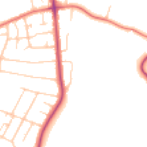
Daytime· 07:00 – 23:00
47.3dB

Night-time· 23:00 – 07:00
38.7dB