10 Fitzroy Lane, Cambridge, CB1 1HE
About 10 Fitzroy Lane
10 Fitzroy Lane is a two-bedroom semi-detached house in Cambridge (CB1 1HE). It has a recorded floor area of 85 m² (around 915 sq ft), construction records dating it to 1983-1990 and council tax band D. The latest certificate (March 2015) shows a C (score 70). The rating has held steady at C across 2 certificates since March 2010. Between certificates, roof efficiency dropped from Average to Poor and hot-water efficiency dropped from Very Good to Good. The latest certificate is from March 2015, so improvements made since then won't be reflected. Other recorded features include a balcony. Period features are noted in the property record.
Across 2000–2011, sale prices on this property compounded at 6.7% per year. Today's modelled estimate of £423,000 sits 74.8% above the 2011 sale of £242,000. On a £-per-square-foot basis, the last sale (£265/sq ft) was about 52.8% above the typical sold price in the postcode. 15 years since the last transfer (August 2011).
What this property has
Inside
- Bedrooms2
- Dining roomYes
Outside
- Private gardenYes
- BalconyYes
Building
- Central heatingYes
- Period featuresYes
Everything you need to know about 10 Fitzroy Lane
The true value, the hidden risks and the full sale history, in one report.
Pick your report · every report is £14.99
One time fee only - money back guarantee

The data behind every report


Energy performance
10 Fitzroy Lane's EPC is over a decade old — improvements since won't be reflected.
EPC Expired
This certificate is over 10 years old and is no longer valid.Expired 11 Mar 2025
EPC Rating
Get a survey for this property
Level 2 HomeBuyer Report
We've checked 10 risk factors against the available data for this property and believe a Level 2 HomeBuyer Report could be a suitable option for you.
From £695 · Includes VAT
Planning history
10 Fitzroy Lane has no planning applications on record.
But the area is active
6 notable applications nearby — larger schemes and conversions that could reshape the street. The report maps them all.
Sales history & valuation
Sale price has at least doubled since 2000.
£423,000
Modelled from EPC, postcode comparables and a sale-price growth of 6.7% per year over 11 years.
£242,000
Growth on file: 6.7% per year over 11 years.
Sales timeline
16 August 2011Most recent
£242,000
-1.2%over 3 years30 August 2007
£245,000
+113.0%over 7 years24 February 2000
£115,000
Median price across the last 5 sales in CB1 1HE: £240,000 (2022–2007).
Versus other Fitzroy Lane homes
On years held, 10 Fitzroy Lane runs well behind the street norm.
Price per m²
£2,847
Street avg £2,797
Floor Area
85 m²
Street avg 80 m²
Habitable Rooms
3 rooms
Street avg 4 rooms
CO₂ Emissions
3.0 t/year
Street avg 2.8 t/year
Everything you need to know about 10 Fitzroy Lane
The true value, the hidden risks and the full sale history, in one report.
Pick your report · every report is £14.99
One time fee only - money back guarantee
The data behind every report
Similar properties nearby
1 Christs Court, Victoria Street
CB1 1JN
1 Fitzroy Lane
CB1 1HE
1 Garden Court
CB1 1DW
1 Elm Street
CB1 1EJ
1 Guthrie Court, Paradise Street
CB1 1AJ
1 Eden Court, Eden Street
CB1 1ES
1 Eden Street
CB1 1EL
1 Jesus Terrace
CB1 1JY
The neighbourhood at a glance
Reported crime in the wider district is trending notably upward year-on-year.
Crime
4/mo
Rising year-on-year across the wider district.
Nearest stop
1.5 km
Cambridge Rail Station — railway station.
Closest school
0.3 km
Parkside Community College. 26 schools nearby.
Go deeper on the local area
A Local Area report breaks down crime, transport links, schools and air quality in depth.
Road noise across the postcode
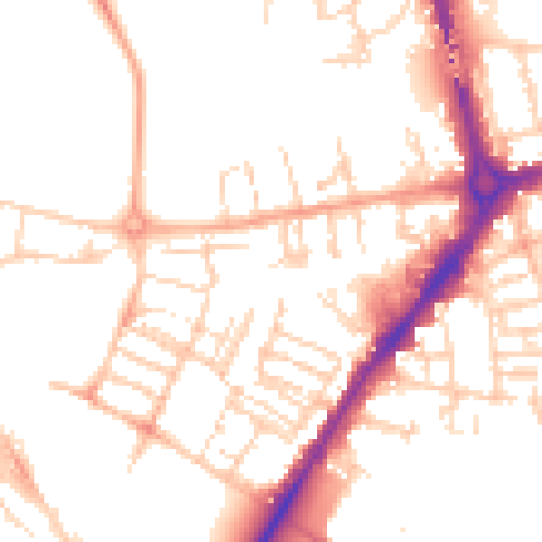
Daytime· 07:00 – 23:00
51.0dB

Night-time· 23:00 – 07:00
40.6dB