10 Benfield Close, Portslade, Brighton, BN41 2DD
About 10 Benfield Close
10 Benfield Close is a two-bedroom semi-detached house in Portslade, Brighton, Brighton (BN41 2DD). It has a recorded floor area of 74 m² (around 797 sq ft), construction records dating it to 1950-1966 and council tax band D. The latest certificate (June 2013) shows a D (score 68), on the cusp of jumping into the C band. The recommended improvements would lift it to B (score 85), a 2-band jump. The latest certificate is from June 2013, so improvements made since then won't be reflected. The home occupies a cul-de-sac position.
Today's modelled estimate of £400,000 sits 60% above the 2013 sale of £250,000. On a £-per-square-foot basis, the last sale (£314/sq ft) was about 30.7% above the typical sold price in the postcode. On the market in August 2013 and unlisted since — roughly 13 years. At 74 m² it's 27.8% smaller than the typical home in the postcode (103 m² median across 6 EPCs).
Know exactly what you're buying at 10 Benfield Close
Before you offer, see what the listing won't tell you, the true value, the red flags and the full history.
Already flagged here
Valuation
against the asking price
Risks
planning & flood
Sold prices
similar homes nearby
Trends
the local market
What this property has
Inside
- Bedrooms2
- Dining roomYes
Outside
- GarageYes
- Cul-de-sacYes
Energy performance
Recommended upgrades on file would lift this property by multiple EPC bands.
EPC Expired
This certificate is over 10 years old and is no longer valid.Expired 24 Jun 2023
EPC Rating
Planning history
10 Benfield Close has no planning applications on record.
Notable planning nearby
2applications of note in the surrounding area
We flagged 1 thing worth checking at 10 Benfield Close
Independent checks surfaced things a buyer would want to understand before offering. The report explains each one in full, with the underlying data and what to ask.
- Larger development activity nearby
30-day money-back guarantee
Sales history & valuation
10 Benfield Close valuation sits well clear of the typical sold price in this postcode.
£400,000
Modelled from EPC, postcode comparables.
£250,000
Recorded with HM Land Registry.
Sales timeline
15 August 2013Most recent
£250,000
Median price across the last 5 sales in BN41 2DD: £360,000 (2020–2012).
Nearby sales in BN41 2DD
2 Benfield Close, Portslade, Brighton, BN41 2DD
Sold Oct 2020
£465,0001 Benfield Close, Portslade, Brighton, BN41 2DD
Sold May 2018
£360,0003 Benfield Close, Portslade, Brighton, BN41 2DD
Sold May 2017
£365,4365 Benfield Close, Portslade, Brighton, BN41 2DD
Sold Aug 2012
£340,0006 Benfield Close, Portslade, Brighton, BN41 2DD
Sold Oct 2008
£195,000
Everything we know about 10 Benfield Close, in one report
What it's really worth, what could be wrong, and the planning, sales and area data in full.
What we flagged
- Larger development activity nearby

Versus other Benfield Close homes
On co₂ emissions, 10 Benfield Close stands well clear of the street.
Price per m²
£3,378
Street avg £3,300
Floor Area
74 m²
Street avg 101 m²
Habitable Rooms
3 rooms
Street avg 5 rooms
CO₂ Emissions
2.7 t/year
Street avg 3.9 t/year
Similar properties nearby
1 Dean Gardens, Portslade
BN41 2FW
1 Badger Close, Portslade
BN41 2EQ
1 Compass Court, Oakdene Crescent, Portslade
BN41 2SD
1 Coach House Mews, South Street, Portslade
BN41 2LE
1 Bush Cottage Close, Portslade
BN41 2GU
1 Avery Close, Portslade
BN41 2WP
1 Chalky Road, Portslade
BN41 2WF
1 Easthill Drive, Portslade
BN41 2FD
The neighbourhood at a glance
Rail-style transport is unusually close for this postcode.
Crime
4/mo
Steady year-on-year across the wider district.
Nearest stop
0.1 km
Highlands Road — bus stop.
Closest school
0.2 km
Benfield Primary School. 22 schools nearby.
Go deeper on the local area
The full report breaks down crime, transport links, schools and air quality in depth.
Road noise across the postcode
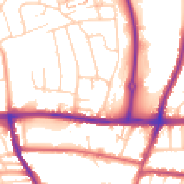
Daytime· 07:00 – 23:00
54.1dB

Night-time· 23:00 – 07:00
45.0dB