11a, Alma Road, Bournemouth, BH9 1AA
About 11a
11a is a two-bedroom detached house in Bournemouth (BH9 1AA). It has a recorded floor area of 64 m² (around 689 sq ft), construction records dating it to 1930-1949 and council tax band A. The latest certificate (January 2016) shows an E (score 53), well below the UK norm with real room to improve. When first surveyed in March 2010 the rating was G, the property has climbed 2 bands since. Between certificates, window efficiency went from Average to Good, hot-water efficiency went from Very Poor to Good and main heating went from Poor to Good; while roof efficiency dropped from Poor to Very Poor. The recommended improvements would push it to D (score 63). The latest certificate is from January 2016, so improvements made since then won't be reflected. At 64 m² this is the 3rd smallest of 12 units on EPC record in the building, where floor areas span 45–161 m². The building's EPC ratings span E to C, with this unit at the bottom. On EPC score it ranks last in the building (53 versus a best of 78).
It hasn't traded since March 2002, a hold of 24 years that's notably long for the area. On energy efficiency it sits in the bottom 10% of properties in this postcode — significant headroom for improvement. Today's modelled estimate of £176,000 sits 147.9% above the 2002 sale of £71,000. On a £-per-square-foot basis, the last sale (£103/sq ft) was about 23.8% below the postcode norm.
What this property has
Inside
- Bedrooms2
- Bathrooms1
Outside
- Private gardenYes
Building
- ConciergeYes
- RefurbishedYes
Everything you need to know about 11a
The true value, the hidden risks and the full sale history, in one report.
Pick your report · every report is £14.99
One time fee only - money back guarantee

The data behind every report


Energy performance
11a sits at the bottom of the postcode for energy efficiency — meaningful headroom to improve.
EPC Expired
This certificate is over 10 years old and is no longer valid.Expired 19 Jan 2026
EPC Rating
Property Improvements
Changes detected from historical EPC data
Replaced storage heaters with gas boiler
Connected to mains gas supply
Heating controls upgraded for better temperature management
Hot water system upgraded
More low energy lighting installed
Window efficiency improved
Get a survey for this property
Level 2 HomeBuyer Report
We've checked 10 risk factors against the available data for this property and believe a Level 2 HomeBuyer Report could be a suitable option for you.
From £495 · Includes VAT
Planning history
11a has no planning applications on record.
But the area is active
78 notable applications nearby — larger schemes and conversions that could reshape the street. The report maps them all.
Sales history & valuation
£176,000
Modelled from EPC, postcode comparables.
£71,000
Recorded with HM Land Registry.
Sales timeline
26 March 2002Most recent
£71,000
Median price across the last 5 sales in BH9 1AA: £194,950 (2023–2015).
Nearby sales in BH9 1AA
Versus other Alma Road homes
EPC Rating for 11a lags the street by a wide margin.
Price per m²
£1,109
Street avg £1,954
Floor Area
64 m²
Street avg 72 m²
Habitable Rooms
3 rooms
Street avg 3 rooms
CO₂ Emissions
4.1 t/year
Street avg 2.7 t/year
Everything you need to know about 11a
The true value, the hidden risks and the full sale history, in one report.
Pick your report · every report is £14.99
One time fee only - money back guarantee
The data behind every report
Similar properties nearby
The neighbourhood at a glance
Crime
4/mo
Steady year-on-year across the wider district.
Nearest stop
0.0 km
Winton Banks — bus stop.
Closest school
0.6 km
St Luke's Church of England Primary School. 26 schools nearby.
Go deeper on the local area
A Local Area report breaks down crime, transport links, schools and air quality in depth.
Road noise across the postcode
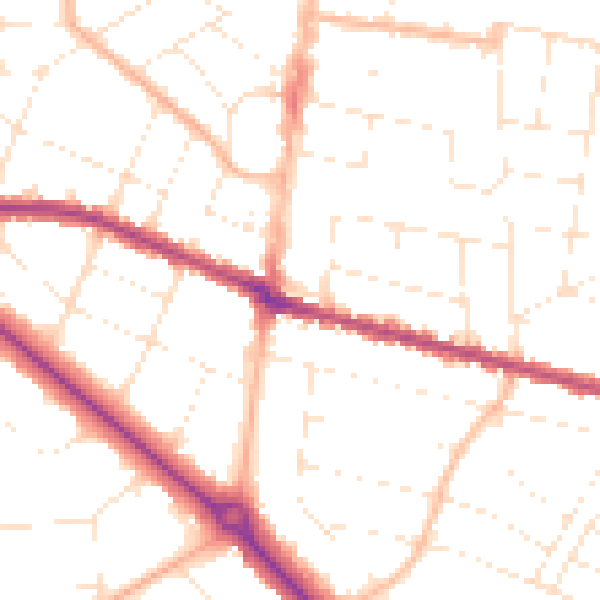
Daytime· 07:00 – 23:00
50.4dB

Night-time· 23:00 – 07:00
40.1dB