25 Croft Gardens, Wolverhampton, WV10 6GG
About 25 Croft Gardens
25 Croft Gardens is a mid-terrace house in Wolverhampton (WV10 6GG). It has a recorded floor area of 77 m² (around 829 sq ft). The latest certificate (October 2016) returns a B (score 84), comfortably above the UK average. The recommended improvements would push it to A (score 97).
On the market in March 2017 and unlisted since — roughly 9 years. Today's modelled estimate of £222,000 is 33.8% above the 2017 sale price.
Everything you need to know about 25 Croft Gardens
The true value, the hidden risks and the full sale history, in one report.
Pick your report · every report is £14.99
One time fee only - money back guarantee

The data behind every report


Energy performance
25 Croft Gardens's carbon output is low for the local stock.
EPC Rating
Get a survey for this property
Level 2 HomeBuyer Report
We've checked 10 risk factors against the available data for this property and believe a Level 2 HomeBuyer Report could be a suitable option for you.
From £545 · Includes VAT
Planning history
25 Croft Gardens has no planning applications on record.
But the area is active
2 notable applications nearby — larger schemes and conversions that could reshape the street. The report maps them all.
Sales history & valuation
25 Croft Gardens valuation sits well clear of the typical sold price in this postcode.
£222,000
Modelled from EPC, postcode comparables.
£165,950
Recorded with HM Land Registry.
Sales timeline
24 March 2017Most recent
£165,950
Median price across the last 5 sales in WV10 6GG: £219,950 (2025–2024).
Nearby sales in WV10 6GG
11 Croft Gardens, Wolverhampton, WV10 6GG
Sold Aug 2025
£288,00042 Croft Gardens, Wolverhampton, WV10 6GG
Sold Aug 2025
£323,00040 Croft Gardens, Wolverhampton, WV10 6GG
Sold May 2025
£195,00048 Croft Gardens, Wolverhampton, WV10 6GG
Sold Feb 2025
£219,95021 Croft Gardens, Wolverhampton, WV10 6GG
Sold Jan 2021
£186,995
Versus other Croft Gardens homes
25 Croft Gardens outperforms the street on co₂ emissions by a wide margin.
Price per m²
£2,155
Street avg £2,346
Floor Area
77 m²
Street avg 78 m²
CO₂ Emissions
1.1 t/year
Street avg 1.3 t/year
Years Held
9 years
Street avg 8 years
Everything you need to know about 25 Croft Gardens
The true value, the hidden risks and the full sale history, in one report.
Pick your report · every report is £14.99
One time fee only - money back guarantee
The data behind every report
Similar properties nearby
The neighbourhood at a glance
Crime
6/mo
Steady year-on-year across the wider district.
Nearest stop
2.1 km
Moog — bus stop.
Closest school
0.7 km
Bushbury Lane Academy. 31 schools nearby.
Go deeper on the local area
A Local Area report breaks down crime, transport links, schools and air quality in depth.
Road noise across the postcode
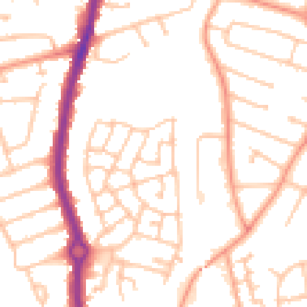
Daytime· 07:00 – 23:00
51.0dB

Night-time· 23:00 – 07:00
39.8dB