229b, Flat 2, St Albans Road, Watford, WD24 5BQ
About 229b
229b is a mid-terrace house in Watford (WD24 5BQ). It has a recorded floor area of 44 m² (around 474 sq ft) and construction records dating it to 1900-1929. The latest certificate (December 2018) shows an E (score 40), well below the UK norm with real room to improve. When first surveyed in January 2011 the rating was F, the property has climbed 1 band since. Between certificates, hot-water efficiency went from Very Poor to Poor; while roof efficiency dropped from Average to Very Poor and window efficiency dropped from Good to Average. The recommended improvements would lift it to C (score 69), a 2-band jump. Main heating runs on electricity.
It lags the bulk of the postcode on energy efficiency (less efficient than 74% of similar EPCs).
Everything you need to know about 229b
The true value, the hidden risks and the full sale history, in one report.
30-day money-back guarantee

The data behind every report


Energy performance
Recommended upgrades on file would lift this property by multiple EPC bands.
EPC Rating
Property Improvements
Changes detected from historical EPC data
Hot water system upgraded
Planning history
229b has no planning applications on record.
Notable planning nearby
3applications of note in the surrounding area
Sales history & valuation
229b has no Land Registry sales on file, suggesting it has stayed in the same hands since registration began.
£210,000
Modelled from EPC, postcode comparables.
No sales recorded with HM Land Registry
That can mean the property has never traded since the registry began publishing in 1995, was a new build that hasn't been registered yet, or is held in the same hands long-term.
Median price across the last 5 sales in WD24 5BQ: £205,000 (2023–2019).
Nearby sales in WD24 5BQ
Flat 2, 255 St Albans Road, Watford, WD24 5BQ
Sold Feb 2023
£185,000237a, St Albans Road, Watford, WD24 5BQ
Sold Oct 2022
£552,500Flat 3, 255 St Albans Road, Watford, WD24 5BQ
Sold Oct 2022
£205,000Flat 5, 255 St Albans Road, Watford, WD24 5BQ
Sold Jul 2022
£215,000Flat 4, 255 St Albans Road, Watford, WD24 5BQ
Sold Nov 2019
£180,000
Versus other St Albans Road homes
229b is notably below the street on epc rating.
EPC Rating
40 (E)
Street avg 60 (D)
Floor Area
44 m²
Street avg 51 m²
CO₂ Emissions
4.2 t/year
Street avg 3.0 t/year
Habitable Rooms
2 rooms
Street avg 3 rooms
Everything you need to know about 229b
The true value, the hidden risks and the full sale history, in one report.
30-day money-back guarantee
The data behind every report
Similar properties nearby
Beall Court 2a, Flat 9, Dodd Road
WD24 5FL
Beall Court 2a, Flat 10, Dodd Road
WD24 5FL
Beall Court 2a, Flat 11, Dodd Road
WD24 5FL
Beall Court 2a, Flat 12, Dodd Road
WD24 5FL
Beall Court 2a, Flat 13, Dodd Road
WD24 5FL
Beall Court 2a, Flat 14, Dodd Road
WD24 5FL
Beall Court 2a, Flat 15, Dodd Road
WD24 5FL
Beall Court 2a, Flat 4, Dodd Road
WD24 5FL
The neighbourhood at a glance
Rail-style transport is unusually close for this postcode.
Crime
4/mo
Rising year-on-year across the wider district.
Nearest stop
0.1 km
Regent Street — bus stop.
Closest school
0.5 km
Parkgate Junior School. 34 schools nearby.
Go deeper on the local area
The full report breaks down crime, transport links, schools and air quality in depth.
Road noise across the postcode
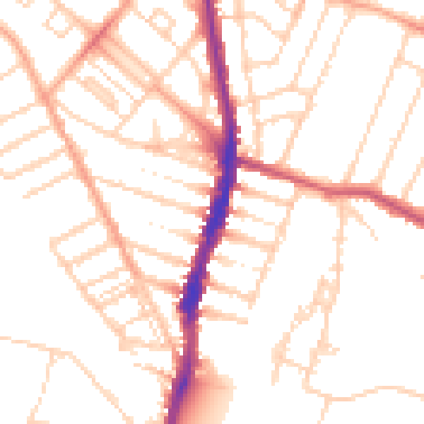
Daytime· 07:00 – 23:00
50.9dB

Night-time· 23:00 – 07:00
40.5dB