47 St James Road, Watford, WD18 0DZ
About 47 St James Road
47 St James Road is a property in Watford (WD18 0DZ). It has council tax band D.
Untraded for 26 years, with the last transfer in November 2000. Only one transfer is on record with HM Land Registry, suggesting it has stayed in the same hands for a long time. 3 planning records sit against the property, 0 approved, 2 refused, 1 pending. An active application for a loft conversion is awaiting a decision.
Know exactly what you're buying at 47 St James Road
Before you offer, see what the listing won't tell you, the true value, the red flags and the full history.
Already flagged here
Valuation
against the asking price
Risks
planning & flood
Sold prices
similar homes nearby
Trends
the local market
Energy performance
No EPC on record
This property doesn't have an Energy Performance Certificate yet. An EPC is required to sell or let — and unlocks our automated valuation.
Planning history
- Jan 2021Loft ConversionAmendmentIn report
Lawful Development Certificate for roof space alteration to form enlarged bedroom and proposed dormer on rear outrigger
- Documents
- 5 docs on file
- Reference
- 21/00089/LDC
- Jan 2021Loft ConversionAmendmentIn report
Lawful Development Certificate for proposed dormer on rear outrigger.
- Documents
- 10 docs on file
- Reference
- 20/01333/LDC
We flagged 1 thing worth checking at 47 St James Road
Independent checks surfaced things a buyer would want to understand before offering. The report explains each one in full, with the underlying data and what to ask.
- Signs of HMO activity in the area
30-day money-back guarantee
Sales history & valuation
£105,000
Recorded with HM Land Registry.
Sales timeline
3 November 2000Most recent
£105,000
Median price across the last 5 sales in WD18 0DZ: £388,000 (2024–2007).
Nearby sales in WD18 0DZ
Everything we know about 47 St James Road, in one report
What it's really worth, what could be wrong, and the planning, sales and area data in full.
What we flagged
- Signs of HMO activity in the area

Similar properties nearby
The neighbourhood at a glance
Rail-style transport is unusually close for this postcode.
Crime
8/mo
Steady year-on-year across the wider district.
Nearest stop
0.1 km
The Hornets — bus stop.
Closest school
0.1 km
Watford Grammar School for Girls. 36 schools nearby.
Go deeper on the local area
The full report breaks down crime, transport links, schools and air quality in depth.
Road noise across the postcode
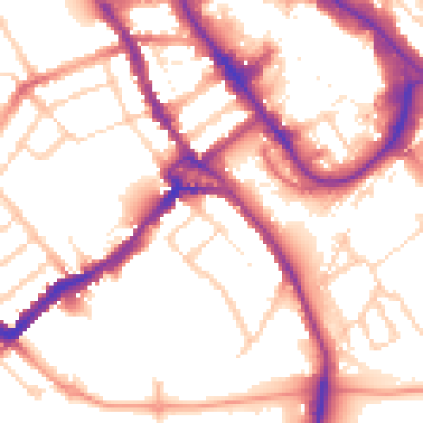
Daytime· 07:00 – 23:00
54.5dB

Night-time· 23:00 – 07:00
45.1dB