Are you a property professional?Get qualified leads from motivated homeowners.
Get started9a, Arden Road, Ealing, London, W13 8RP
About 9a
A plain-English summary derived from public records, EPC certificates, sold prices and local data.
9a is a one-bedroom mid-terrace house in Ealing, London, London (W13 8RP). It has a recorded floor area of 49 m² (around 527 sq ft), construction records dating it to 1900-1929 and council tax band D. The latest certificate (July 2019) shows a D (score 64), on the cusp of jumping into the C band. The rating has held steady at D across 2 certificates since March 2009. Between certificates, lighting went from Very Poor to Very Good. The recommended improvements would push it to C (score 76). At 49 m² this is the 9th smallest of 17 units on EPC record in the building, where floor areas span 30–90 m². The building's EPC ratings span E to C across 17 units on file.
Untraded for 24 years, with the last transfer in September 2002. Today's modelled estimate of £355,000 sits 144.8% above the 2002 sale of £145,000. At 49 m² it's 20.6% larger than the typical home in the postcode (41 m² median across 19 EPCs).
What this property has
Pulled from EPC certificates, claim submissions and our property model. Empty categories are hidden — we only show what's known.
Inside
- Bedrooms1
Building
- Central heatingYes
- RefurbishedYes
Energy performance
Every EPC certificate filed against this property — current rating, recorded improvements, and where there's headroom to reach a higher band.
Current Certificate(1 of 2)
Jul 2019
EPC Rating
A
B
C
D
D64
E
F
G
Main Heating
Gas
Main Fuel
Gas
Hot Water
Good
Windows
Good
CO2 Emissions
2.4 t/year
Occupancy
Rented
Sales history & valuation
Recorded transactions, our model's current estimate, and a quick read on what neighbouring properties have sold for.
9a valuation sits well clear of the typical sold price in this postcode.
Current estimate
See how we calculated this£355,000
Modelled from EPC, postcode comparables.
Last sold (2002)
£145,000
Recorded with HM Land Registry.
Sales timeline
Launch offer · 33% off
The complete analysis of 9a, Arden Road, Ealing, London, W13 8RP
Everything we know about this property, compiled into one in-depth, downloadable report.
Detailed AI analysis
An AI-written breakdown of everything that matters
Versus other Arden Road homes
Four headline reads against 19 similar flats on this street, drawn from the latest EPC and Land Registry data.
9a outperforms the street on years held by a wide margin.
Price per m²
£2,959
Street avg £5,412
Floor Area
49 m²
Street avg 50 m²
Habitable Rooms
3 rooms
Street avg 3 rooms
Similar properties nearby
A handful of close matches in the same postcode area, ranked by likeness on bedrooms, type and floor area.
The neighbourhood at a glance
A condensed read of the local area. Each tile links through to the full breakdown on the London district page.
Rail-style transport is unusually close for this postcode.
Crime
4/mo
Rising year-on-year across the wider district.
Nearest stop
0.1 km
Broughton Road — bus stop.
Road noise across the postcode
Modelled day and night-time noise levels around W13 8RP from Defra's strategic mapping. The pin marks this postcode's centroid.
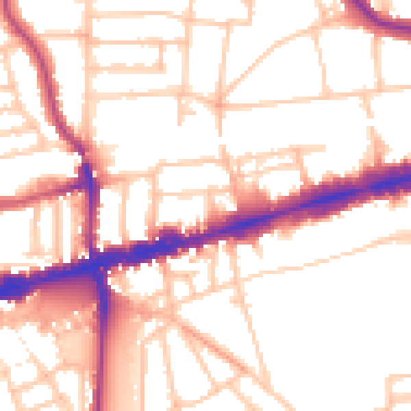
Daytime· 07:00 – 23:00
53.3dB

Everything within walking distance
Schools, transport stops and scenic spots near this property — 67 points of interest in total.
Common questions
The questions buyers, sellers and homeowners most often ask about 9a, Arden Road, Ealing, London, W13 8RP. Each answer is also embedded as structured data for search engines.
