Queens Head House, Flat 1, Ashford Road, Charing, Ashford, TN27 0AD
About Queens Head House
Queens Head House is a detached house in Charing, Ashford, Ashford (TN27 0AD). It has a recorded floor area of 85 m² (around 915 sq ft), construction records dating it to 1930-1949 and council tax band C. The latest certificate (October 2024) shows a D (score 63), on the cusp of jumping into the C band. The recommended improvements would push it to C (score 72).
4 planning records sit against the property, 1 approved, 0 refused. Past consents include solar panel installation, meaningful when judging how the property has evolved.
Everything you need to know about Queens Head House
The true value, the hidden risks and the full sale history, in one report.
30-day money-back guarantee

The data behind every report


Energy performance
EPC Rating
Planning history
Planning records include a solar-panel installation at Queens Head House.
- Nov 2020Tree WorksTreesIn report
Description: T1 Ash tree - carry out an approximate 30% reduction (2 - 3 metres, leaving approximately 12 - 15 metres) with a proportional width reduction, raising crown over the highway to 5.2 metres and removing major dead wood cutting to appropriate branch axis.
- Documents
- 4 docs on file
- Reference
- 20/00264/TC
- Mar 2012Solar PanelsFullIn report
Fitting Solar PV Panels to South-East Elevation of Roof
- Documents
- 6 docs on file
- Reference
- 12/00132/AS
What's in Queens Head House, Flat 1, Ashford Road, Charing, Ashford, TN27 0AD's planning history?
2 more on this property, plus refusals, disputes and full decisions nearby, in the report.
Sales history & valuation
Queens Head House has no Land Registry sales on file, suggesting it has stayed in the same hands since registration began.
£251,000
Modelled from EPC, postcode comparables.
No sales recorded with HM Land Registry
That can mean the property has never traded since the registry began publishing in 1995, was a new build that hasn't been registered yet, or is held in the same hands long-term.
Everything you need to know about Queens Head House
The true value, the hidden risks and the full sale history, in one report.
30-day money-back guarantee
The data behind every report
Similar properties nearby
5 Grove Flats, The Grove, Pluckley
TN27 0RR
2 Grove Flats, The Grove, Pluckley
TN27 0RR
Hardwick House, Flat 1, Pluckley Road, Charing
TN27 0AG
6 Grove Flats, The Grove, Pluckley
TN27 0RR
Hardwick House, Flat 4, Pluckley Road, Charing
TN27 0AG
Hardwick House, Flat 2, Pluckley Road, Charing
TN27 0AG
Hardwick House, Flat 3, Pluckley Road, Charing
TN27 0AG
Elizabethan Court, Flat 1, High Street, Charing
TN27 0LS
The neighbourhood at a glance
Rail-style transport is unusually close for this postcode.
Crime
2/mo
Steady year-on-year across the wider district.
Nearest stop
0.0 km
The Moat — bus stop.
Closest school
0.2 km
Charing Church of England Primary School. 1 school nearby.
Go deeper on the local area
The full report breaks down crime, transport links, schools and air quality in depth.
Road noise across the postcode
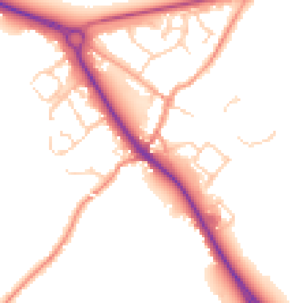
Daytime· 07:00 – 23:00
51.8dB
Night-time· 23:00 – 07:00
43.0dB