4 Bishop Street, Shrewsbury, SY2 5HA
About 4 Bishop Street
4 Bishop Street is a semi-detached house in Shrewsbury (SY2 5HA). It has a recorded floor area of 151 m² (around 1625 sq ft), construction records dating it to 1900-1929 and council tax band C. The latest certificate (September 2019) shows a D (score 62), on the cusp of jumping into the C band. The recommended improvements would push it to C (score 79).
At 151 m² the property is well over the postcode median (107 m² across 13 EPCs), placing it in the larger end of the local stock. Most recent transfer was May 2025 at £400,000 — fresh data. Across 2020–2025, sale prices on this property compounded at 5.2% per year. On a £-per-square-foot basis, the last sale (£246/sq ft) was about 50.5% above the typical sold price in the postcode. One historical planning record sits against the property in 2021.
Everything you need to know about 4 Bishop Street
The true value, the hidden risks and the full sale history, in one report.
30-day money-back guarantee

The data behind every report


Energy performance
4 Bishop Street's carbon output runs well above what efficient homes in the postcode produce.
EPC Rating
Planning history
- Dec 2021RenovationFullIn report
Insertion of replacement front door and replace side entrance with brace gate and frame
- Documents
- 11 docs on file
- Reference
- 21/05168/FUL
We flagged 1 thing worth checking at 4 Bishop Street
Independent checks surfaced things a buyer would want to understand before offering. The report explains each one in full, with the underlying data and what to ask.
- Larger development activity nearby
30-day money-back guarantee
Sales history & valuation
4 Bishop Street valuation sits well clear of the typical sold price in this postcode.
£413,000
Modelled from EPC, postcode comparables and a sale-price growth of 5.2% per year over 5 years.
£400,000
Growth on file: 5.2% per year over 5 years.
Sales timeline
29 May 2025Most recent
£400,000
+31.1%over 5 years24 January 2020
£305,000
Median price across the last 5 sales in SY2 5HA: £330,000 (2023–2019).
Nearby sales in SY2 5HA
Versus other Bishop Street homes
On years held, 4 Bishop Street runs well behind the street norm.
Price per m²
£2,649
Street avg £2,447
Floor Area
151 m²
Street avg 118 m²
Habitable Rooms
6 rooms
Street avg 6 rooms
CO₂ Emissions
6.7 t/year
Street avg 6.2 t/year
Everything you need to know about 4 Bishop Street
The true value, the hidden risks and the full sale history, in one report.
30-day money-back guarantee
The data behind every report
Similar properties nearby
The neighbourhood at a glance
Rail-style transport is unusually close for this postcode.
Crime
1/mo
Steady year-on-year across the wider district.
Nearest stop
1.0 km
Shrewsbury Rail Station — railway station.
Closest school
0.7 km
Crowmoor Primary School. 20 schools nearby.
Go deeper on the local area
The full report breaks down crime, transport links, schools and air quality in depth.
Road noise across the postcode
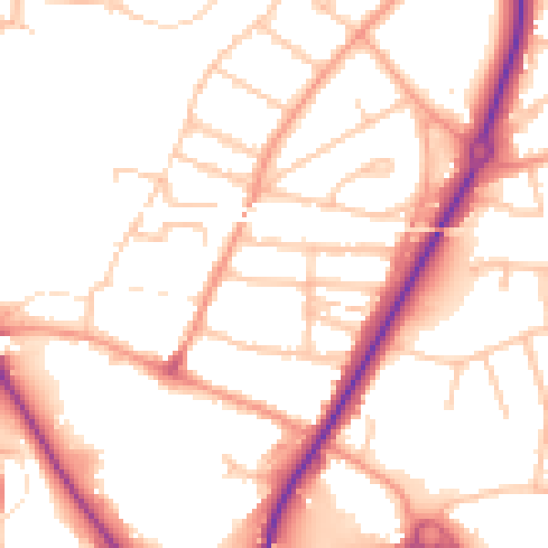
Daytime· 07:00 – 23:00
51.7dB

Night-time· 23:00 – 07:00
42.1dB