1 Alfred Street, Shrewsbury, SY2 5EX
About 1 Alfred Street
1 Alfred Street is an end-of-terrace house in Shrewsbury (SY2 5EX). It has a recorded floor area of 141 m² (around 1518 sq ft), construction records dating it to 1900-1929 and council tax band C. The latest certificate (April 2018) shows a D (score 55), a step below the typical UK home. The recommended improvements would lift it to B (score 85), a 2-band jump.
At 141 m² the property is well over the postcode median (101 m² across 16 EPCs), placing it in the larger end of the local stock. 2 planning records sit against the property, 1 approved, 0 refused. The record references conservation-area consent, which constrain future alterations.
Everything you need to know about 1 Alfred Street
The true value, the hidden risks and the full sale history, in one report.
30-day money-back guarantee

The data behind every report


Energy performance
1 Alfred Street's carbon output runs well above what efficient homes in the postcode produce.
EPC Rating
Planning history
1 Alfred Street sits within a conservation area — exterior works face additional planning controls.
- Mar 2022Tree WorksTreesIn report
To reduce crown height of 1no. Holly by 1.5 m and re-shape (as per photograph) protected by the Shrewsbury Conservation Area
Conservation Area- Documents
- 4 docs on file
- Reference
- 22/01252/TCA
- Sept 2009FullIn report
Replacement pathway, hard surfacing to front of house and erection of metal railings and gate (Article 4 Direction) (Amended Description)
- Documents
- 10 docs on file
- Reference
- 09/01770/FUL
We flagged 1 thing worth checking at 1 Alfred Street
Independent checks surfaced things a buyer would want to understand before offering. The report explains each one in full, with the underlying data and what to ask.
- Larger development activity nearby
30-day money-back guarantee
Sales history & valuation
1 Alfred Street has no Land Registry sales on file, suggesting it has stayed in the same hands since registration began.
£342,000
Modelled from EPC, postcode comparables.
No sales recorded with HM Land Registry
That can mean the property has never traded since the registry began publishing in 1995, was a new build that hasn't been registered yet, or is held in the same hands long-term.
Median price across the last 5 sales in SY2 5EX: £334,000 (2025–2023).
Nearby sales in SY2 5EX
Versus other Alfred Street homes
1 Alfred Street outperforms the street on floor area by a wide margin.
EPC Rating
55 (D)
Street avg 58 (D)
Floor Area
141 m²
Street avg 105 m²
CO₂ Emissions
7.6 t/year
Street avg 5.3 t/year
Habitable Rooms
7 rooms
Street avg 6 rooms
Everything you need to know about 1 Alfred Street
The true value, the hidden risks and the full sale history, in one report.
30-day money-back guarantee
The data behind every report
Similar properties nearby
The neighbourhood at a glance
Crime
1/mo
Steady year-on-year across the wider district.
Nearest stop
1.1 km
Shrewsbury Rail Station — railway station.
Closest school
0.6 km
Crowmoor Primary School. 19 schools nearby.
Go deeper on the local area
The full report breaks down crime, transport links, schools and air quality in depth.
Road noise across the postcode
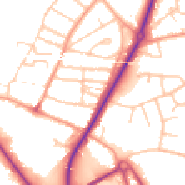
Daytime· 07:00 – 23:00
52.3dB

Night-time· 23:00 – 07:00
42.6dB