149 Monkmoor Road, Shrewsbury, SY2 5BB
About 149 Monkmoor Road
149 Monkmoor Road is a four-bedroom semi-detached house in Shrewsbury (SY2 5BB). It has a recorded floor area of 140 m² (around 1507 sq ft), construction records dating it to 1976-1982 and council tax band C. The latest certificate (October 2019) shows a C (score 70). When first surveyed in December 2013 the rating was D, the property has climbed 1 band since. Between certificates, roof efficiency went from Very Poor to Poor and lighting went from Poor to Very Good. Records show the property has been extended at some point in its history. The home occupies a cul-de-sac position.
At 140 m² the property is well over the postcode median (97 m² across 16 EPCs), placing it in the larger end of the local stock. Its energy rating outperforms most of the postcode (better than 75% of similar EPCs). 3 planning records sit against the property, 3 approved, 0 refused. Past consents include an extension and a conservatory, meaningful when judging how the property has evolved. Across 2000–2019, sale prices on this property compounded at 7.6% per year. Today's modelled estimate of £383,000 is 21.6% above the 2019 sale price. On a £-per-square-foot basis, the last sale (£209/sq ft) was about 20.8% above the typical sold price in the postcode. Sold November 2019 for £315,000.
What this property has
Inside
- Bedrooms4
- Bathrooms1
- Open-plan layoutYes
- CloakroomYes
- EnsuiteYes
Outside
- Private gardenRear
- Cul-de-sacYes
Building
- Heating systemGas
- Previously extendedYes
Everything you need to know about 149 Monkmoor Road
The true value, the hidden risks and the full sale history, in one report.
30-day money-back guarantee

The data behind every report


Energy performance
EPC Rating
Property Improvements
Changes detected from historical EPC data
Heating controls upgraded for better temperature management
More low energy lighting installed
Planning history
149 Monkmoor Road has an approved single-storey rear extension on the planning record.
- Feb 2017ExtensionAmendmentIn report
Extension: Two storey
Non Material Amendment relating to previously approved planning permission 16/05180/FUL Erection of two storey side extension and alterations to existing rear conservatory and internal re-modelling works
- Documents
- 9 docs on file
- Reference
- 17/00788/AMP
- Jan 2017ConservatoryFullIn report
Extension: Two storey · Side of property
Erection of two storey side extension and alterations to existing rear conservatory and internal re-modelling works
Extension- Documents
- 13 docs on file
- Reference
- 16/05180/FUL
We flagged 1 thing worth checking at 149 Monkmoor Road
Independent checks surfaced things a buyer would want to understand before offering. The report explains each one in full, with the underlying data and what to ask.
- Larger development activity nearby
30-day money-back guarantee
Sales history & valuation
Latest sale on 149 Monkmoor Road was the highest on Land Registry record across the postcode.
£383,000
Modelled from EPC, postcode comparables and a sale-price growth of 7.6% per year over 20 years.
£315,000
Growth on file: 7.6% per year over 20 years.
Sales timeline
15 November 2019Most recent
£315,000
+57.9%over 5 years3 April 2014
£199,500
+166.0%over 13 years11 May 2000
£75,000
Median price across the last 5 sales in SY2 5BB: £300,000 (2023–2019).
Nearby sales in SY2 5BB
Versus other Monkmoor Road homes
Floor Area for 149 Monkmoor Road runs comfortably ahead of the street norm.
Price per m²
£2,250
Street avg £2,017
Floor Area
140 m²
Street avg 101 m²
Habitable Rooms
5 rooms
Street avg 5 rooms
CO₂ Emissions
4.2 t/year
Street avg 4.5 t/year
Everything you need to know about 149 Monkmoor Road
The true value, the hidden risks and the full sale history, in one report.
30-day money-back guarantee
The data behind every report
Similar properties nearby
1 Burkitt Close
SY2 5WN
1 Burnham Avenue
SY2 5LL
1 Belgrave Place
SY2 5LJ
1 Abbots Place
SY2 5PY
1 Brighton Terrace, Bradford Street
SY2 5DS
1 Abbots Road
SY2 5PX
1 Allness Close
SY2 5XH
1 Alvaston Way
SY2 5TT
The neighbourhood at a glance
Crime
1/mo
Steady year-on-year across the wider district.
Nearest stop
1.2 km
Shrewsbury Rail Station — railway station.
Closest school
0.6 km
Crowmoor Primary School. 18 schools nearby.
Go deeper on the local area
The full report breaks down crime, transport links, schools and air quality in depth.
Road noise across the postcode
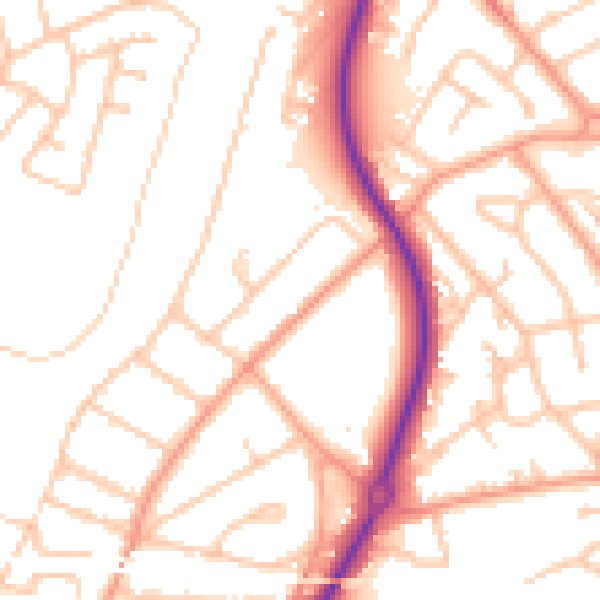
Daytime· 07:00 – 23:00
52.0dB

Night-time· 23:00 – 07:00
41.2dB