Are you a property professional?Get qualified leads from motivated homeowners.
Get started33 Cavendish Road, Merton, London, SW19 2ET
About 33 Cavendish Road
A plain-English summary derived from public records, EPC certificates, sold prices and local data.
33 Cavendish Road is a three-bedroom mid-terrace house in Merton, London, London (SW19 2ET). It has a recorded floor area of 97 m² (around 1044 sq ft), construction records dating it to 1900-1929 and council tax band D. The latest certificate (March 2018) shows a D (score 64), on the cusp of jumping into the C band. The recommended improvements would push it to C (score 80).
Held since April 2007 — that's 19 years off the open market, well above the local norm. That sale landed at the peak of the pre-credit-crunch market, which is a useful reference point when interpreting the price. Today's modelled estimate of £747,000 sits 126.4% above the 2007 sale of £330,000.
What this property has
Pulled from EPC certificates, claim submissions and our property model. Empty categories are hidden — we only show what's known.
Inside
- Bedrooms3
- Bathrooms2
Energy performance
Every EPC certificate filed against this property — current rating, recorded improvements, and where there's headroom to reach a higher band.
EPC Rating
A
B
C
D
D64
E
F
G
Main Heating
Gas
Main Fuel
Gas
Hot Water
Good
Windows
Good
CO2 Emissions
3.8 t/year
Occupancy
Rented
Sales history & valuation
Recorded transactions, our model's current estimate, and a quick read on what neighbouring properties have sold for.
The latest sale landed at the peak of the pre-credit-crunch market — a high-water reference point.
Current estimate
See how we calculated this£747,000
Modelled from EPC, postcode comparables.
Last sold (2007)
£330,000
Recorded with HM Land Registry.
Sales timeline
Full property reportLaunch offer · 33% off
The complete analysis of 33 Cavendish Road, Merton, London, SW19 2ET
Everything we know about this property, compiled into one in-depth, downloadable report.
Detailed AI analysis
Versus other Cavendish Road homes
Four headline reads against 16 similar houses on this street, drawn from the latest EPC and Land Registry data.
On years held, 33 Cavendish Road stands well clear of the street.
Price per m²
£3,402
Street avg £6,185
Floor Area
97 m²
Street avg 110 m²
Habitable Rooms
5 rooms
Similar properties nearby
A handful of close matches in the same postcode area, ranked by likeness on bedrooms, type and floor area.
The neighbourhood at a glance
A condensed read of the local area. Each tile links through to the full breakdown on the London district page.
Rail-style transport is unusually close for this postcode.
Crime
6/mo
Rising year-on-year across the wider district.
Nearest stop
0.2 km
Walpole Road — bus stop.
Road noise across the postcode
Modelled day and night-time noise levels around SW19 2ET from Defra's strategic mapping. The pin marks this postcode's centroid.
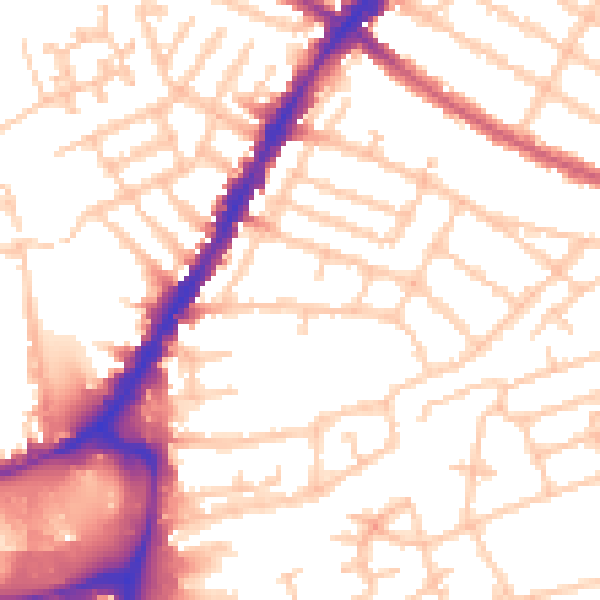
Daytime· 07:00 – 23:00
53.9dB

Everything within walking distance
Schools, transport stops and scenic spots near this property — 85 points of interest in total.
Common questions
The questions buyers, sellers and homeowners most often ask about 33 Cavendish Road, Merton, London, SW19 2ET. Each answer is also embedded as structured data for search engines.