Are you a property professional?Get qualified leads from motivated homeowners.
Get started40 Atney Road, Wandsworth, London, SW15 2PS
3 sales on record
About 40 Atney Road
A plain-English summary derived from public records, EPC certificates, sold prices and local data.
40 Atney Road is a two-bedroom mid-terrace house in Wandsworth, London, London (SW15 2PS). It has a recorded floor area of 56 m² (around 603 sq ft), construction records dating it to 1983-1990 and council tax band D. Tenure is freehold. The latest certificate (April 2024) shows a C (score 75), near the top of the C band. When first surveyed in April 2009 the rating was D, the property has climbed 1 band since. Between certificates, wall efficiency went from Very Poor to Good, roof efficiency went from Very Poor to Average and hot-water efficiency went from Average to Good. The recommended improvements would push it to B (score 90). Period features are noted in the property record.
Sale prices here have outpaced London HPI: 4.1% per year against 0% for the wider region. On a £-per-square-foot basis, the last sale (£1,037/sq ft) was about 145.6% above the typical sold price in the postcode. One planning record on file: new windows approved in 2025. Past consents include new windows, meaningful when judging how the property has evolved. At 56 m² it's 15.2% smaller than the typical home in the postcode (66 m² median across 43 EPCs). Last sale on file: £625,000 in July 2024.
What this property has
Pulled from EPC certificates, claim submissions and our property model. Empty categories are hidden — we only show what's known.
Inside
- Bedrooms2
- Bathrooms1
Outside
- GarageYes
Building
Energy performance
Every EPC certificate filed against this property — current rating, recorded improvements, and where there's headroom to reach a higher band.
40 Atney Road's carbon output is low for the local stock.
Current Certificate(1 of 2)
Apr 2024
EPC Rating
A
B
C
C75
D
E
F
G
Main Heating
Gas
Main Fuel
Gas
Hot Water
Good
Windows
Good
CO2 Emissions
1.5 t/year
Occupancy
Owner Occupied
Planning history
Applications and permits filed against 40 Atney Road, Wandsworth, London, SW15 2PS, sourced from the PlanIt planning register.
- May 2025RenovationFullApprove with Conditions
Alterations including increase in roof height by 150mm to allow additoinal insulation, installation of external wall cladding and replacement double glazed aluminium framed windows, with double glazed bifold doors to rear and new composite front door.
Sales history & valuation
Recorded transactions, our model's current estimate, and a quick read on what neighbouring properties have sold for.
Sale price has at least doubled since 2004.
Current estimate
See how we calculated this£670,000
Modelled from EPC, postcode comparables and a sale-price growth of 4.1% per year over 20 years.
Last sold (2024)
£625,000
Growth on file: 4.1% per year over 20 years.
Sales timeline
Versus other Atney Road homes
Four headline reads against 11 similar houses on this street, drawn from the latest EPC and Land Registry data.
Price per m² for 40 Atney Road runs comfortably ahead of the street norm.
Price per m²
£11,161
Street avg £7,514
Floor Area
56 m²
Street avg 151 m²
Habitable Rooms
3 rooms
Similar properties nearby
A handful of close matches in the same postcode area, ranked by likeness on bedrooms, type and floor area.
The neighbourhood at a glance
A condensed read of the local area. Each tile links through to the full breakdown on the London district page.
Rail-style transport is unusually close for this postcode.
Crime
7/mo
Rising year-on-year across the wider district.
Nearest stop
0.1 km
Brewhouse Lane — bus stop.
Road noise across the postcode
Modelled day and night-time noise levels around SW15 2PS from Defra's strategic mapping. The pin marks this postcode's centroid.
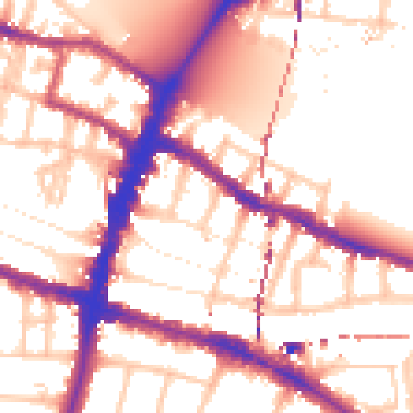
Daytime· 07:00 – 23:00
56.0dB

Everything within walking distance
Schools, transport stops and scenic spots near this property — 87 points of interest in total.
Beautiful places to visit nearby
Curated scenic spots within reach of this postcode, served by Beautifulplaces.ai. Photography and tagging come from their open dataset.
Common questions
The questions buyers, sellers and homeowners most often ask about 40 Atney Road, Wandsworth, London, SW15 2PS. Each answer is also embedded as structured data for search engines.