36 The Village, Walton, Stafford, ST17 0LQ
About 36 The Village
36 The Village is a four-bedroom detached house in Walton, Stafford, Stafford (ST17 0LQ). It has a recorded floor area of 178 m² (around 1916 sq ft), construction records dating it to 1900-1929 and council tax band G. The latest certificate (April 2022) shows a D (score 64), on the cusp of jumping into the C band. The recommended improvements would push it to C (score 79). Period features are noted in the property record. Records show the property has been extended at some point in its history.
At 178 m² the property is well over the postcode median (123 m² across 21 EPCs), placing it in the larger end of the local stock. Across 1996–2023, sale prices on this property compounded at 6.2% per year. On a £-per-square-foot basis, the last sale (£329/sq ft) was about 33.8% above the typical sold price in the postcode. 2 planning records sit against the property, 0 approved, 0 refused. Most recent transfer: May 2023 at £630,000.
What this property has
Inside
- Bedrooms4
- Bathrooms2
- Dining roomYes
- EnsuiteYes
Outside
- GarageYes
Building
- Period featuresYes
- Previously extendedYes
Everything you need to know about 36 The Village
The true value, the hidden risks and the full sale history, in one report.
Pick your report · every report is £14.99
One time fee only - money back guarantee

The data behind every report


Energy performance
36 The Village's carbon output runs well above what efficient homes in the postcode produce.
EPC Rating
Get a survey for this property
Level 3 Building Survey
Because the property was built before 1919 and has been extended more than once, we believe a Level 3 building survey should be considered.
From £1,155 · Includes VAT
Planning history
2 applications on record at 36 The Village, Walton, Stafford, ST17 0LQ
- Dec 2023ExtensionFullOutcome in report
Extension: Single storey · Rear of property
Single storey rear extension with roof and posts to match existing. Alterations to door and window on the side elevation.
- Documents
- 13 docs on file
- Reference
- 23/38127/HOU
- More recent applications — locked
- Tree WorksJan 2025Decision
Unlock 36 The Village, Walton, Stafford, ST17 0LQ's full planning history
You're seeing the shape of it. The report has the substance.
- Every decision — granted, refused or withdrawn (2 on record)
- All 2 applications on this property in full, plus 1 notable nearby
- The 15 documents, officer reports & conditions
- What the pattern means for extending or converting here
One time fee only - money back guarantee
Sales history & valuation
36 The Village has more than quadrupled in price since its earliest registered sale in 1996.
£665,000
Modelled from EPC, postcode comparables and a sale-price growth of 6.2% per year over 27 years.
£630,000
Growth on file: 6.2% per year over 27 years.
Sales timeline
2 May 2023Most recent
£630,000
+162.5%over 23 years11 August 1999
£240,000
+62.2%over 1 year28 August 1997
£148,000
+15.2%over 11 months12 September 1996
£128,500
Median price across the last 5 sales in ST17 0LQ: £450,000 (2025–2021).
Nearby sales in ST17 0LQ
4 The Village, Walton, Stafford, ST17 0LQ
Sold May 2025
£450,00034 The Village, Walton, Stafford, ST17 0LQ
Sold Oct 2024
£500,00031 The Village, Walton, Stafford, ST17 0LQ
Sold Apr 2024
£500,00021 The Village, Walton, Stafford, ST17 0LQ
Sold Dec 2023
£280,00019 The Village, Walton, Stafford, ST17 0LQ
Sold Dec 2021
£365,000
Versus other The Village homes
36 The Village outperforms the street on floor area by a wide margin.
Price per m²
£3,539
Street avg £2,965
Floor Area
178 m²
Street avg 139 m²
Habitable Rooms
8 rooms
Street avg 7 rooms
CO₂ Emissions
7.5 t/year
Street avg 6.3 t/year
Everything you need to know about 36 The Village
The true value, the hidden risks and the full sale history, in one report.
Pick your report · every report is £14.99
One time fee only - money back guarantee
The data behind every report
Similar properties nearby
1 Alsop Crest, Acton Trussell
ST17 0SJ
1 Briar Close
ST17 0NG
1 Bank Top Cottage, Top Road, Acton Trussell
ST17 0RQ
1 Belvedere Close
ST17 0AL
1 Ascot Road
ST17 0AG
1 Baswich Crest
ST17 0HL
1 Beechfield Drive
ST17 0YH
1 Anson Drive
ST17 0LT
The neighbourhood at a glance
Daytime road noise here sits well below conversation level — a quiet pocket of the postcode.
Crime
3/mo
Steady year-on-year across the wider district.
Nearest stop
0.3 km
Kitlings Lane — bus stop.
Closest school
0.2 km
Berkswich CofE (VC) Primary School. 8 schools nearby.
Go deeper on the local area
A Local Area report breaks down crime, transport links, schools and air quality in depth.
Road noise across the postcode
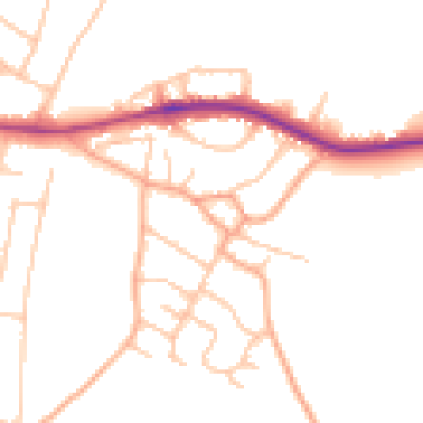
Daytime· 07:00 – 23:00
48.5dB

Night-time· 23:00 – 07:00
39.7dB