7 Barnard Street, Sunderland, SR4 7RX
About 7 Barnard Street
7 Barnard Street is a four-bedroom property in Sunderland (SR4 7RX). It has council tax band B.
Last changed hands 12 years ago, in March 2014. Across the public record there are 4 sales, relatively high churn for a single property. Across 2003–2014, sale prices on this property compounded at 2.5% per year.
What this property has
Inside
- Bedrooms4
- Open-plan layoutYes
- StudyYes
Outside
- Private gardenYes
- ParkingYes
Building
- Heating systemGas
Everything you need to know about 7 Barnard Street
The true value, the hidden risks and the full sale history, in one report.
Pick your report · every report is £14.99
One time fee only - money back guarantee

The data behind every report


Energy performance
No EPC on record
This property doesn't have an Energy Performance Certificate yet. An EPC is required to sell or let — and unlocks our automated valuation.
Get a survey for this property
Level 2 HomeBuyer Report
We've checked 10 risk factors against the available data for this property and believe a Level 2 HomeBuyer Report could be a suitable option for you.
Planning history
7 Barnard Street has no planning applications on record.
But the area is active
10 notable applications nearby — larger schemes and conversions that could reshape the street. The report maps them all.
Sales history & valuation
£122,000
Growth on file: 2.5% per year over 10 years.
Sales timeline
14 March 2014Most recent
£122,000
-0.8%over 4 years15 January 2010
£123,000
-3.5%over 5 years6 July 2004
£127,500
+34.2%over 7 months24 November 2003
£95,000
Median price across the last 5 sales in SR4 7RX: £145,000 (2025–2024).
Nearby sales in SR4 7RX
Everything you need to know about 7 Barnard Street
The true value, the hidden risks and the full sale history, in one report.
Pick your report · every report is £14.99
One time fee only - money back guarantee
The data behind every report
Similar properties nearby
1 Brinkburn Street
SR4 7RG
1 Arrol Park
SR4 7BS
1 Beachville Street
SR4 7NA
1 Blackett Terrace
SR4 7XD
1 Colchester Terrace
SR4 7RY
1 Broxbourne Terrace
SR4 7DT
1 Bexley Street
SR4 7TL
1 Angrove Gardens
SR4 7TB
The neighbourhood at a glance
Reported crime in the wider district is trending notably upward year-on-year.
Crime
3/mo
Rising year-on-year across the wider district.
Nearest stop
0.1 km
Cleveland Road-Colchester Terrace — bus stop.
Closest school
0.2 km
Barnes Junior School. 40 schools nearby.
Go deeper on the local area
A Local Area report breaks down crime, transport links, schools and air quality in depth.
Road noise across the postcode
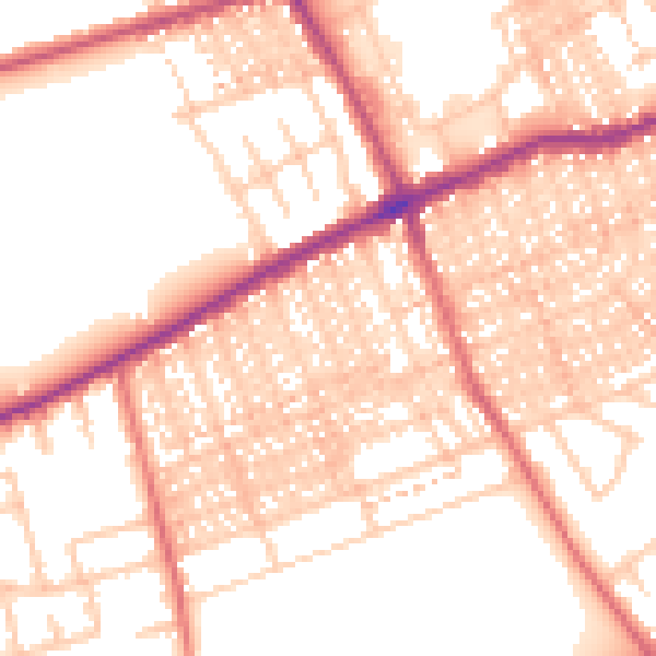
Daytime· 07:00 – 23:00
54.0dB

Night-time· 23:00 – 07:00
43.0dB