13 Duncan Street, Sunderland, SR4 6QR
About 13 Duncan Street
13 Duncan Street is a two-bedroom mid-terrace house in Sunderland (SR4 6QR). It has a recorded floor area of 72 m² (around 775 sq ft), construction records dating it to 1930-1949 and council tax band A. The latest certificate (March 2022) shows a D (score 62), on the cusp of jumping into the C band. The recommended improvements would push it to C (score 76).
Today's modelled estimate of £113,000 sits 59.2% above the 2022 sale of £71,000. On a £-per-square-foot basis, the last sale (£92/sq ft) was about 64.9% above the typical sold price in the postcode. Last sale on file: £71,000 in July 2022. That sale was during the post-pandemic price surge, when transactions cleared materially above pre-2020 trend.
What this property has
Inside
- Bedrooms2
- Bathrooms1
- Dining roomYes
- EnsuiteYes
Outside
- GarageYes
Everything you need to know about 13 Duncan Street
The true value, the hidden risks and the full sale history, in one report.
Pick your report · every report is £14.99
One time fee only - money back guarantee

The data behind every report


Energy performance
EPC Rating
Get a survey for this property
Level 3 Building Survey
Because the property has been extended more than once, we believe a Level 3 building survey should be considered.
From £820 · Includes VAT
Planning history
13 Duncan Street has no planning applications on record.
But the area is active
1 notable application nearby — larger schemes and conversions that could reshape the street. The report maps them all.
Sales history & valuation
The latest sale landed in the post-pandemic price surge — useful context when reading the figure.
£113,000
Modelled from EPC, postcode comparables.
£71,000
Recorded with HM Land Registry.
Sales timeline
17 July 2022Most recent
£71,000
Median price across the last 5 sales in SR4 6QR: £60,000 (2025–2024).
Nearby sales in SR4 6QR
Versus other Duncan Street homes
Price per m²
£986
Street avg £796
Floor Area
72 m²
Street avg 70 m²
Habitable Rooms
4 rooms
Street avg 4 rooms
CO₂ Emissions
3.9 t/year
Street avg 4.0 t/year
Everything you need to know about 13 Duncan Street
The true value, the hidden risks and the full sale history, in one report.
Pick your report · every report is £14.99
One time fee only - money back guarantee
The data behind every report
Similar properties nearby
The neighbourhood at a glance
Rail-style transport is unusually close for this postcode.
Crime
3/mo
Rising year-on-year across the wider district.
Nearest stop
0.1 km
St Lukes Terrace — bus stop.
Closest school
0.2 km
Diamond Hall Infant Academy. 35 schools nearby.
Go deeper on the local area
A Local Area report breaks down crime, transport links, schools and air quality in depth.
Road noise across the postcode
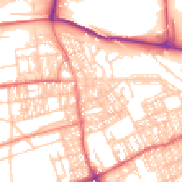
Daytime· 07:00 – 23:00
55.4dB
Night-time· 23:00 – 07:00
43.0dB