20 Coronation Square, Quidhampton, Salisbury, SP2 9BD
About 20 Coronation Square
20 Coronation Square is a semi-detached house in Quidhampton, Salisbury, Salisbury (SP2 9BD). It has a recorded floor area of 79 m² (around 850 sq ft), construction records dating it to 1991-1995 and council tax band B. The latest certificate (February 2021) shows a C (score 71). The recommended improvements would push it to B (score 85).
One historical planning record sits against the property in 2003.
Everything you need to know about 20 Coronation Square
The true value, the hidden risks and the full sale history, in one report.
Pick your report · every report is £14.99
One time fee only - money back guarantee

The data behind every report


Energy performance
EPC Rating
Get a survey for this property
Level 2 HomeBuyer Report
We've checked 10 risk factors against the available data for this property and believe a Level 2 HomeBuyer Report could be a suitable option for you.
From £545 · Includes VAT
Planning history
1 application on record at 20 Coronation Square, Quidhampton, Salisbury, SP2 9BD
- May 2003FullOutcome in report
THREE DWELLINGS TO REPLACE TWO DWELLINGS
- Documents
- 28 docs on file
- Reference
- S/2002/1268
Unlock 20 Coronation Square, Quidhampton, Salisbury, SP2 9BD's full planning history
You're seeing the shape of it. The report has the substance.
- Every decision — granted, refused or withdrawn (1 on record)
- All 1 application on this property in full
- The 28 documents, officer reports & conditions
- What the pattern means for extending or converting here
One time fee only - money back guarantee
Sales history & valuation
20 Coronation Square has no Land Registry sales on file, suggesting it has stayed in the same hands since registration began.
£209,000
Modelled from EPC, postcode comparables.
No sales recorded with HM Land Registry
That can mean the property has never traded since the registry began publishing in 1995, was a new build that hasn't been registered yet, or is held in the same hands long-term.
Median price across the last 5 sales in SP2 9BD: £165,000 (2024–2016).
Nearby sales in SP2 9BD
1 Coronation Square, Quidhampton, Salisbury, SP2 9BD
Sold Oct 2024
£184,00021 Coronation Square, Quidhampton, Salisbury, SP2 9BD
Sold Aug 2017
£325,0006 Coronation Square, Quidhampton, Salisbury, SP2 9BD
Sold May 2017
£165,00015 Coronation Square, Quidhampton, Salisbury, SP2 9BD
Sold Dec 2016
£150,00027 Coronation Square, Quidhampton, Salisbury, SP2 9BD
Sold Jun 2015
£195,000
Versus other Coronation Square homes
On habitable rooms, 20 Coronation Square runs well behind the street norm.
EPC Rating
71 (C)
Street avg 69 (C)
Floor Area
79 m²
Street avg 85 m²
CO₂ Emissions
2.7 t/year
Street avg 3.0 t/year
Habitable Rooms
3 rooms
Street avg 5 rooms
Everything you need to know about 20 Coronation Square
The true value, the hidden risks and the full sale history, in one report.
Pick your report · every report is £14.99
One time fee only - money back guarantee
The data behind every report
Similar properties nearby
The neighbourhood at a glance
Crime
4/mo
Steady year-on-year across the wider district.
Nearest stop
0.1 km
Coronation Square — bus stop.
Closest school
1.2 km
Sarum Academy. 9 schools nearby.
Go deeper on the local area
A Local Area report breaks down crime, transport links, schools and air quality in depth.
Road noise across the postcode
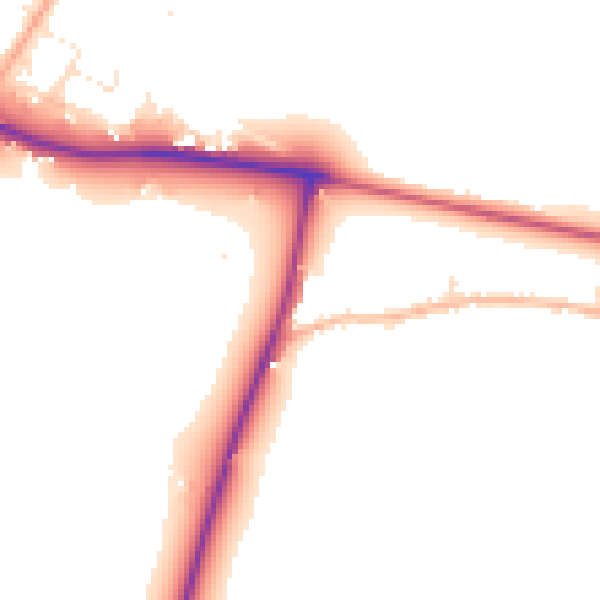
Daytime· 07:00 – 23:00
50.0dB

Night-time· 23:00 – 07:00
44.0dB