13 Anson Drive, Southampton, SO19 8RP
About 13 Anson Drive
13 Anson Drive is a three-bedroom end-of-terrace house in Southampton (SO19 8RP). It has a recorded floor area of 66 m² (around 710 sq ft), construction records dating it to 1983-1990 and council tax band B. The latest certificate (January 2026) shows a C (score 73). When first surveyed in March 2010 the rating was D, the property has climbed 1 band since. Between certificates, roof efficiency dropped from Good to Average and window efficiency dropped from Good to Average. This certificate was lodged in the last six months, so the rating reflects current condition.
Across 2005–2013, sale prices on this property compounded at 1.7% per year. Today's modelled estimate of £250,000 sits 61.3% above the 2013 sale of £155,000. On a £-per-square-foot basis, the last sale (£218/sq ft) was about 25.4% above the typical sold price in the postcode. On the market in July 2013 and unlisted since — roughly 13 years.
What this property has
Inside
- Bedrooms3
- Dining roomYes
Outside
- ParkingOff road
Everything you need to know about 13 Anson Drive
The true value, the hidden risks and the full sale history, in one report.
Pick your report · every report is £14.99
One time fee only - money back guarantee

The data behind every report


Energy performance
The EPC has just been inspected, so the rating reflects current condition.
EPC Rating
Property Improvements
Changes detected from historical EPC data
Heating controls upgraded for better temperature management
More low energy lighting installed
Get a survey for this property
Level 2 HomeBuyer Report
We've checked 10 risk factors against the available data for this property and believe a Level 2 HomeBuyer Report could be a suitable option for you.
From £545 · Includes VAT
Planning history
13 Anson Drive has no planning applications on record.
A planning report still maps activity across the surrounding area and reads this property's extension & conversion potential.
Sales history & valuation
13 Anson Drive saw 3 transfers in just over a decade — high turnover for the postcode.
£250,000
Modelled from EPC, postcode comparables and a sale-price growth of 1.7% per year over 8 years.
£155,000
Growth on file: 1.7% per year over 8 years.
Sales timeline
25 July 2013Most recent
£155,000
-1.3%over 2 years26 July 2010
£157,000
+15.0%over 4 years9 December 2005
£136,500
Median price across the last 5 sales in SO19 8RP: £250,000 (2025–2017).
Nearby sales in SO19 8RP
Versus other Anson Drive homes
On floor area, 13 Anson Drive runs well behind the street norm.
Price per m²
£2,348
Street avg £2,493
Floor Area
66 m²
Street avg 81 m²
Habitable Rooms
4 rooms
Street avg 5 rooms
CO₂ Emissions
1.9 t/year
Street avg 3.0 t/year
Everything you need to know about 13 Anson Drive
The true value, the hidden risks and the full sale history, in one report.
Pick your report · every report is £14.99
One time fee only - money back guarantee
The data behind every report
Similar properties nearby
1 Gladstone Road
SO19 8GU
1 Church View Close
SO19 8SJ
1 Fair Green
SO19 8QW
1 Cleethorpes Road
SO19 8AS
1 Compass Close
SO19 8QA
1 Effingham Gardens
SO19 8GF
1 Botany Bay Road
SO19 8LT
1 Coalville Road
SO19 8GQ
The neighbourhood at a glance
Crime
12/mo
Steady year-on-year across the wider district.
Nearest stop
0.1 km
High Firs Road — bus stop.
Closest school
0.5 km
Thornhill Primary School. 30 schools nearby.
Go deeper on the local area
A Local Area report breaks down crime, transport links, schools and air quality in depth.
Road noise across the postcode
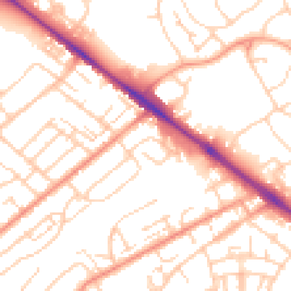
Daytime· 07:00 – 23:00
53.1dB

Night-time· 23:00 – 07:00
41.9dB