11 Ennerdale Road, Woodley, Stockport, SK6 1BJ
About 11 Ennerdale Road
11 Ennerdale Road is a property in Woodley, Stockport, Stockport (SK6 1BJ). It has council tax band C.
It hasn't traded since October 2001, a hold of 25 years that's notably long for the area.
Everything you need to know about 11 Ennerdale Road
The true value, the hidden risks and the full sale history, in one report.
Pick your report · every report is £14.99
One time fee only - money back guarantee

The data behind every report


Energy performance
No EPC on record
This property doesn't have an Energy Performance Certificate yet. An EPC is required to sell or let — and unlocks our automated valuation.
Get a survey for this property
Level 2 HomeBuyer Report
We've checked 10 risk factors against the available data for this property and believe a Level 2 HomeBuyer Report could be a suitable option for you.
Planning history
11 Ennerdale Road has no planning applications on record.
But the area is active
2 notable applications nearby — larger schemes and conversions that could reshape the street. The report maps them all.
Sales history & valuation
£96,850
Recorded with HM Land Registry.
Sales timeline
2 October 2001Most recent
£96,850
Median price across the last 5 sales in SK6 1BJ: £315,000 (2025–2024).
Nearby sales in SK6 1BJ
6 Ennerdale Road, Woodley, Stockport, SK6 1BJ
Sold Nov 2025
£375,75016 Ennerdale Road, Woodley, Stockport, SK6 1BJ
Sold Jun 2025
£280,00026 Ennerdale Road, Woodley, Stockport, SK6 1BJ
Sold Feb 2025
£375,00019 Ennerdale Road, Woodley, Stockport, SK6 1BJ
Sold Sept 2024
£265,00032 Ennerdale Road, Woodley, Stockport, SK6 1BJ
Sold Jun 2024
£315,000
Everything you need to know about 11 Ennerdale Road
The true value, the hidden risks and the full sale history, in one report.
Pick your report · every report is £14.99
One time fee only - money back guarantee
The data behind every report
Similar properties nearby
1 Bankfield Cottages, Woodley
SK6 1RG
1 Ennerdale Road, Woodley
SK6 1BJ
1 Chorlton Fold, Woodley
SK6 1NZ
1 Birchall Green, Woodley
SK6 1RZ
1 Briar Grove, Woodley
SK6 1QW
1 Delamere Close, Woodley
SK6 1LF
1 Clough Meadow, Woodley
SK6 1JZ
1 Ashton Street, Woodley
SK6 1PB
The neighbourhood at a glance
Rail-style transport is unusually close for this postcode.
Crime
1/mo
Steady year-on-year across the wider district.
Nearest stop
0.3 km
Copage Drive — bus stop.
Closest school
0.5 km
Bredbury St. Marks CofE Primary School. 20 schools nearby.
Go deeper on the local area
A Local Area report breaks down crime, transport links, schools and air quality in depth.
Road noise across the postcode
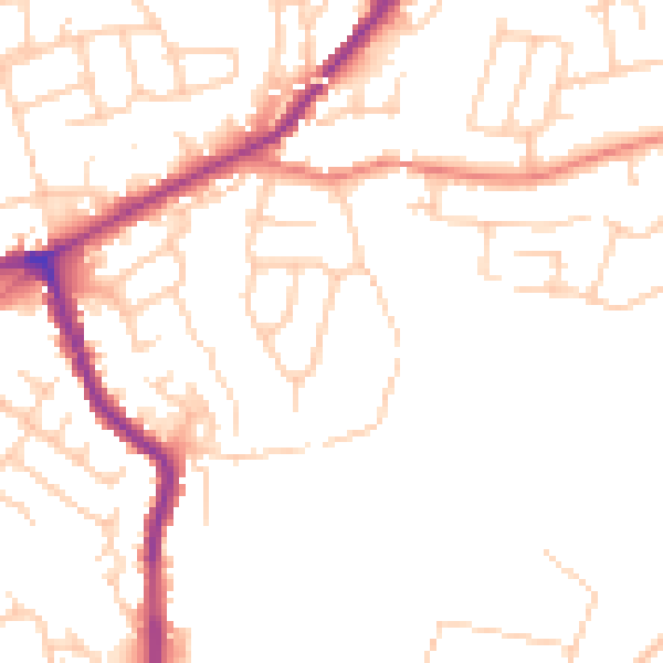
Daytime· 07:00 – 23:00
49.5dB

Night-time· 23:00 – 07:00
40.0dB