12 Elm Court, Maplecroft, Stockport, SK1 4JY
About 12 Elm Court
12 Elm Court is a mid-terrace house in Stockport (SK1 4JY). It has a recorded floor area of 38 m² (around 409 sq ft), construction records dating it to 1976-1982 and council tax band A. At 38 m² this is the 14th smallest of 28 units on EPC record in the building, where floor areas span 31–80 m². The building's EPC ratings span D to B across 28 units on file. The latest certificate (December 2013) shows a C (score 76), near the top of the C band. The latest certificate is from December 2013, so improvements made since then won't be reflected.
Everything you need to know about 12 Elm Court
The true value, the hidden risks and the full sale history, in one report.
Pick your report · every report is £14.99
One time fee only - money back guarantee

The data behind every report


Energy performance
12 Elm Court's carbon output is low for the local stock.
EPC Expired
This certificate is over 10 years old and is no longer valid.Expired 04 Dec 2023
EPC Rating
Get a survey for this property
Level 2 HomeBuyer Report
We've checked 10 risk factors against the available data for this property and believe a Level 2 HomeBuyer Report could be a suitable option for you.
From £495 · Includes VAT
Planning history
12 Elm Court has no planning applications on record.
A planning report still maps activity across the surrounding area and reads this property's extension & conversion potential.
Sales history & valuation
12 Elm Court has no Land Registry sales on file, suggesting it has stayed in the same hands since registration began.
£120,000
Modelled from EPC, postcode comparables.
No sales recorded with HM Land Registry
That can mean the property has never traded since the registry began publishing in 1995, was a new build that hasn't been registered yet, or is held in the same hands long-term.
Median price across the last 1 sales in SK1 4JY: £140,000 (2008–2008).
Nearby sales in SK1 4JY
Versus other Maplecroft homes
EPC Rating
76 (C)
Street avg 75 (C)
Floor Area
38 m²
Street avg 41 m²
CO₂ Emissions
1.2 t/year
Street avg 1.4 t/year
Habitable Rooms
2 rooms
Street avg 2 rooms
Everything you need to know about 12 Elm Court
The true value, the hidden risks and the full sale history, in one report.
Pick your report · every report is £14.99
One time fee only - money back guarantee
The data behind every report
Similar properties nearby
The neighbourhood at a glance
Crime
1/mo
Steady year-on-year across the wider district.
Nearest stop
0.1 km
Marsland Terrace — bus stop.
Closest school
0.1 km
Banks Lane Infant School. 37 schools nearby.
Go deeper on the local area
A Local Area report breaks down crime, transport links, schools and air quality in depth.
Road noise across the postcode
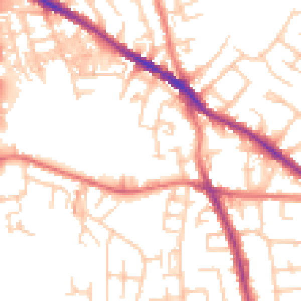
Daytime· 07:00 – 23:00
52.5dB

Night-time· 23:00 – 07:00
41.5dB