54b, Nunhead Lane, Southwark, London, SE15 3TU
About 54b
54b is a semi-detached house in Southwark, London, London (SE15 3TU). It has a recorded floor area of 67 m² (around 721 sq ft), construction records dating it to before 1900 and council tax band C. The latest certificate (September 2020) shows a D (score 67), on the cusp of jumping into the C band. When first surveyed in March 2010 the rating was E, the property has climbed 1 band since. Between certificates, window efficiency went from Very Poor to Average. The recommended improvements would push it to C (score 77). At 67 m² this is the 14th smallest of 20 units on EPC record in the building, where floor areas span 23–138 m². The building's EPC ratings span E to B across 20 units on file.
Across 2019–2021, sale prices on this property compounded at 44.1% per year. Today's modelled estimate of £466,000 is 60.3% below the 2021 sale of £1,175,000, a rare downward gap that often correlates with deferred maintenance or unfinished works. On a £-per-square-foot basis, the last sale (£1,629/sq ft) was about 465.1% above the typical sold price in the postcode. At 67 m² it's 15.5% larger than the typical home in the postcode (58 m² median across 19 EPCs). It lags the bulk of the postcode on energy efficiency (less efficient than 79% of similar EPCs). Most recent transfer: March 2021 at £1,175,000. That sale was during the post-pandemic price surge, when transactions cleared materially above pre-2020 trend.
Know exactly what you're buying at 54b
Before you offer, see what the listing won't tell you, the true value, the red flags and the full history.
Already flagged here
Launch offer · save £5
Valuation
against the asking price
Risks
planning & flood
Sold prices
similar homes nearby
Trends
the local market
Energy performance
EPC Rating
Property Improvements
Changes detected from historical EPC data
Heating controls upgraded for better temperature management
Single glazing replaced with double or better glazing
Low energy lighting percentage decreased
Planning history
54b has no planning applications on record.
Notable planning nearby
5applications of note in the surrounding area
We flagged 3 things worth checking at 54b
Independent checks surfaced things a buyer would want to understand before offering. The report explains each one in full, with the underlying data and what to ask.
- Signs of HMO activity in the area
- Larger development activity nearby
- Recent ownership pattern worth a look
30-day money-back guarantee
Sales history & valuation
Latest sale on 54b was the highest on Land Registry record across the postcode.
£466,000
Modelled from EPC, postcode comparables and a sale-price growth of 44.1% per year over 1 year.
£1,175,000
Growth on file: 44.1% per year over 1 year.
Sales timeline
17 March 2021Most recent
£1,175,000
+68.1%over 1 year15 October 2019
£699,000
Median price across the last 5 sales in SE15 3TU: £500,000 (2022–2014).
Nearby sales in SE15 3TU
48 Nunhead Lane, Southwark, London, SE15 3TU
Sold Jan 2022
£20,00052 Nunhead Lane, Southwark, London, SE15 3TU
Sold Jun 2021
£600,00054a, Nunhead Lane, Southwark, London, SE15 3TU
Sold Apr 2021
£575,000Flat C, 48 Nunhead Lane, London, SE15 3TU
Sold Aug 2019
£500,000Flat 3, 28 Nunhead Lane, Southwark, London, SE15 3TU
Sold Sept 2014
£375,000
Everything we know about 54b, in one report
What it's really worth, what could be wrong, and the planning, sales and area data in full.
What we flagged
- Signs of HMO activity in the area
- Larger development activity nearby
- Recent ownership pattern worth a look

Versus other Nunhead Lane homes
Price per m² for 54b runs comfortably ahead of the street norm.
Price per m²
£17,537
Street avg £5,695
Floor Area
67 m²
Street avg 52 m²
Habitable Rooms
3 rooms
Street avg 3 rooms
CO₂ Emissions
2.6 t/year
Street avg 2.2 t/year
Similar properties nearby
1 Banstead Street, Southwark
SE15 3EX
1 Brackley Avenue, Southwark
SE15 3LE
1 Barset Road, Southwark
SE15 3HW
1 Galatea Square, Southwark
SE15 3PL
1 Abbotsbury Mews, Southwark
SE15 3LU
1 3, Flat 2, Scylla Road, Southwark
SE15 3NY
1 Habitat Close, Southwark
SE15 3RE
1 Forester Road, Southwark
SE15 3PU
The neighbourhood at a glance
Rail-style transport is unusually close for this postcode.
Crime
11/mo
Rising year-on-year across the wider district.
Nearest stop
0.1 km
Carden Road — bus stop.
Closest school
0.1 km
Rye Oak Primary School. 74 schools nearby.
Go deeper on the local area
The full report breaks down crime, transport links, schools and air quality in depth.
Road noise across the postcode
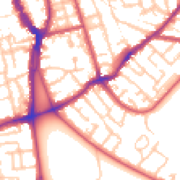
Daytime· 07:00 – 23:00
54.7dB

Night-time· 23:00 – 07:00
44.1dB