6 Farm Close, Coal Aston, Dronfield, S18 3DG
About 6 Farm Close
6 Farm Close is a three-bedroom detached house in Coal Aston, Dronfield, Dronfield (S18 3DG). It has a recorded floor area of 91 m² (around 980 sq ft), construction records dating it to 1967-1975 and council tax band C. The latest certificate (September 2013) shows a D (score 55), a step below the typical UK home. The recommended improvements would push it to C (score 79). The latest certificate is from September 2013, so improvements made since then won't be reflected.
Across 2000–2014, sale prices on this property compounded at 5.5% per year. Today's modelled estimate of £305,000 sits 62.2% above the 2014 sale of £188,000. Last sold in July 2014, so it's been off the market for around 12 years.
Know exactly what you're buying at 6 Farm Close
Before you offer, see what the listing won't tell you, the true value, the red flags and the full history.
Valuation
against the asking price
Risks
planning & flood
Sold prices
similar homes nearby
Trends
the local market
What this property has
Inside
- Bedrooms3
Energy performance
6 Farm Close's EPC is over a decade old — improvements since won't be reflected.
EPC Expired
This certificate is over 10 years old and is no longer valid.Expired 10 Sept 2023
EPC Rating
Planning history
6 Farm Close has no planning applications on record.
The full report still covers planning activity across the surrounding area.
Sales history & valuation
6 Farm Close has more than doubled in price since the earliest registered sale in 2000.
£305,000
Modelled from EPC, postcode comparables and a sale-price growth of 5.5% per year over 14 years.
£188,000
Growth on file: 5.5% per year over 14 years.
Sales timeline
2 July 2014Most recent
£188,000
+109.0%over 13 years17 August 2000
£89,950
Median price across the last 5 sales in S18 3DG: £218,000 (2021–2012).
Nearby sales in S18 3DG
4 Farm Close, Coal Aston, Dronfield, S18 3DG
Sold Sept 2021
£385,00010 Farm Close, Coal Aston, Dronfield, S18 3DG
Sold Oct 2017
£270,00016 Farm Close, Coal Aston, Dronfield, S18 3DG
Sold Aug 2016
£218,00011 Farm Close, Coal Aston, Dronfield, S18 3DG
Sold Aug 2011
£250,00012 Farm Close, Coal Aston, Dronfield, S18 3DG
Sold Nov 2005
£189,950
Everything we know about 6 Farm Close, in one report
What it's really worth, what could be wrong, and the planning, sales and area data in full.
- Am I paying too much?
- Is something wrong with it?
- Is the agent's story true?
- Will it hold its value?

Versus other Farm Close homes
On price per m², 6 Farm Close runs well behind the street norm.
Price per m²
£2,066
Street avg £2,332
Floor Area
91 m²
Street avg 104 m²
Habitable Rooms
6 rooms
Street avg 6 rooms
CO₂ Emissions
5.0 t/year
Street avg 5.0 t/year
Similar properties nearby
1 Ferndale Close, Coal Aston
S18 3BR
1 Thorpe Avenue, Coal Aston
S18 3BB
1 Ferndale Road, Coal Aston
S18 3BT
1 Stone Close, Coal Aston
S18 3AS
1 Westbank Close, Coal Aston
S18 3DE
1 The Ridgeway, Coal Aston
S18 3BY
1 Firthwood Close, Coal Aston
S18 3DD
1 Eckington Road, Coal Aston
S18 3AT
The neighbourhood at a glance
Daytime road noise here sits well below conversation level — a quiet pocket of the postcode.
Crime
5/mo
Steady year-on-year across the wider district.
Nearest stop
0.2 km
Wilson Road — bus stop.
Closest school
0.6 km
Lenthall Infant and Nursery School. 18 schools nearby.
Go deeper on the local area
The full report breaks down crime, transport links, schools and air quality in depth.
Road noise across the postcode
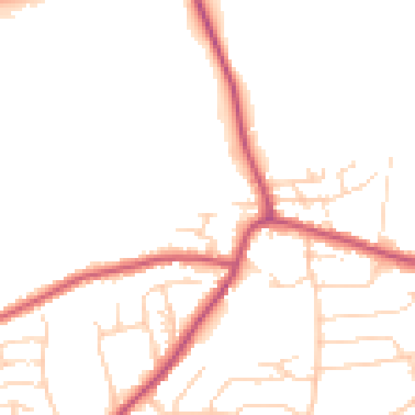
Daytime· 07:00 – 23:00
49.1dB

Night-time· 23:00 – 07:00
40.7dB