26 Cunliffe Street, Coal Aston, Dronfield, S18 3AF
About 26 Cunliffe Street
26 Cunliffe Street is a two-bedroom mid-terrace house in Coal Aston, Dronfield, Dronfield (S18 3AF). It has a recorded floor area of 57 m² (around 614 sq ft), construction records dating it to 1900-1929 and council tax band A. Tenure is freehold. The latest certificate (June 2019) shows a D (score 61), on the cusp of jumping into the C band. The recommended improvements would lift it to B (score 83), a 2-band jump.
Untraded for 17 years, with the last transfer in June 2009. Across the public record there are 4 sales, relatively high churn for a single property. That sale fell during the post-crash dip, which often skews comparisons against later neighbouring sales. Across 1995–2009, sale prices on this property compounded at 7.5% per year. Today's modelled estimate of £187,000 sits 80.7% above the 2009 sale of £103,500. At 57 m² it sits well below the postcode median (84 m² across 17 EPCs), making it one of the more compact homes locally.
Know exactly what you're buying at 26 Cunliffe Street
Before you offer, see what the listing won't tell you, the true value, the red flags and the full history.
Valuation
against the asking price
Risks
planning & flood
Sold prices
similar homes nearby
Trends
the local market
What this property has
Inside
- Bedrooms2
- Bathrooms1
Outside
- Private gardenYes
- GarageYes
Building
- TenureFreehold
- RefurbishedYes
Energy performance
Recommended upgrades on file would lift this property by multiple EPC bands.
EPC Rating
Planning history
26 Cunliffe Street has no planning applications on record.
The full report still covers planning activity across the surrounding area.
Sales history & valuation
Sale price has at least doubled since 1995.
£187,000
Modelled from EPC, postcode comparables and a sale-price growth of 7.5% per year over 14 years.
£103,500
Growth on file: 7.5% per year over 14 years.
Sales timeline
18 June 2009Most recent
£103,500
-1.4%over 4 years30 September 2004
£105,000
+165.8%over 6 years30 January 1998
£39,500
+5.1%over 2 years22 June 1995
£37,600
Median price across the last 5 sales in S18 3AF: £240,000 (2025–2020).
Nearby sales in S18 3AF
12 Cunliffe Street, Coal Aston, Dronfield, S18 3AF
Sold Jul 2025
£362,0002 Cunliffe Street, Coal Aston, Dronfield, S18 3AF
Sold Dec 2024
£200,0006 Cunliffe Street, Coal Aston, Dronfield, S18 3AF
Sold Apr 2024
£240,00021 Cunliffe Street, Coal Aston, Dronfield, S18 3AF
Sold Mar 2021
£220,0008 Cunliffe Street, Coal Aston, Dronfield, S18 3AF
Sold May 2020
£290,000
Everything we know about 26 Cunliffe Street, in one report
What it's really worth, what could be wrong, and the planning, sales and area data in full.
- Am I paying too much?
- Is something wrong with it?
- Is the agent's story true?
- Will it hold its value?

Versus other Cunliffe Street homes
Floor Area for 26 Cunliffe Street lags the street by a wide margin.
Price per m²
£1,816
Street avg £2,106
Floor Area
57 m²
Street avg 90 m²
Habitable Rooms
4 rooms
Street avg 5 rooms
CO₂ Emissions
3.4 t/year
Street avg 4.8 t/year
Similar properties nearby
1 Stone Road, Coal Aston
S18 3AH
1 Ferndale Close, Coal Aston
S18 3BR
1 Westbank Court, Westbank Close, Coal Aston
S18 3DF
1 Thorpe Avenue, Coal Aston
S18 3BB
1 Ferndale Road, Coal Aston
S18 3BT
1 Stone Close, Coal Aston
S18 3AS
10 Eckington Road, Coal Aston
S18 3AT
1 Westbank Close, Coal Aston
S18 3DE
The neighbourhood at a glance
Daytime road noise here sits well below conversation level — a quiet pocket of the postcode.
Crime
5/mo
Steady year-on-year across the wider district.
Nearest stop
0.1 km
Methodist Church — bus stop.
Closest school
0.5 km
Northfield Junior School. 18 schools nearby.
Go deeper on the local area
The full report breaks down crime, transport links, schools and air quality in depth.
Road noise across the postcode
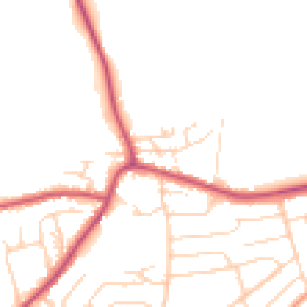
Daytime· 07:00 – 23:00
48.5dB

Night-time· 23:00 – 07:00
40.1dB