1 Claremont Crescent, Newbury, RG14 2FF
About 1 Claremont Crescent
1 Claremont Crescent is a three-bedroom detached house in Newbury (RG14 2FF). It has a recorded floor area of 84 m² (around 904 sq ft), construction records dating it to 1996-2002 and council tax band D. The latest certificate (July 2021) shows a D (score 66), on the cusp of jumping into the C band. Earlier certificates rated it C (January 2011); the latest reading is one band lower. Between certificates, lighting went from Average to Good; while roof efficiency dropped from Good to Average and window efficiency dropped from Good to Average. The recommended improvements would lift it to B (score 85), a 2-band jump.
Last sold in April 2017, so it's been off the market for around 9 years. Across the public record there are 7 sales, relatively high churn for a single property. It lags the bulk of the postcode on energy efficiency (less efficient than 80% of similar EPCs). Across 2003–2017, sale prices on this property compounded at 3.6% per year. Today's modelled estimate of £435,000 is 29.9% above the 2017 sale price. On a £-per-square-foot basis, the last sale (£371/sq ft) was about 38.1% above the typical sold price in the postcode.
Know exactly what you're buying at 1 Claremont Crescent
Before you offer, see what the listing won't tell you, the true value, the red flags and the full history.
Already flagged here
Valuation
against the asking price
Risks
planning & flood
Sold prices
similar homes nearby
Trends
the local market
What this property has
Inside
- Bedrooms3
- Bathrooms2
- Dining roomYes
- CloakroomYes
- EnsuiteYes
Outside
- GarageYes
Building
- RefurbishedYes
Energy performance
Recommended upgrades on file would lift this property by multiple EPC bands.
EPC Rating
Property Improvements
Changes detected from historical EPC data
More low energy lighting installed
Planning history
1 Claremont Crescent has no planning applications on record.
Notable planning nearby
2applications of note in the surrounding area
We flagged 1 thing worth checking at 1 Claremont Crescent
Independent checks surfaced things a buyer would want to understand before offering. The report explains each one in full, with the underlying data and what to ask.
- Larger development activity nearby
30-day money-back guarantee
Sales history & valuation
1 Claremont Crescent has changed hands more often than typical for the area.
£435,000
Modelled from EPC, postcode comparables and a sale-price growth of 3.6% per year over 14 years.
£335,000
Growth on file: 3.6% per year over 14 years.
Sales timeline
12 April 2017Most recent
£335,000
+38.4%over 3 years12 November 2013
£242,000
+3.0%over 2 years17 April 2011
£235,000
-4.1%over 3 years10 May 2007
£244,950
+13.4%over 2 years4 May 2005
£216,000
+3.3%over 1 year15 April 2004
£209,000
+2.0%over 10 months22 June 2003
£205,000
Median price across the last 5 sales in RG14 2FF: £410,000 (2025–2023).
Nearby sales in RG14 2FF
33 Claremont Crescent, Newbury, RG14 2FF
Sold May 2025
£375,00023 Claremont Crescent, Newbury, RG14 2FF
Sold Dec 2024
£410,0007 Claremont Crescent, Newbury, RG14 2FF
Sold Dec 2023
£375,00047 Claremont Crescent, Newbury, RG14 2FF
Sold Mar 2023
£410,00049 Claremont Crescent, Newbury, RG14 2FF
Sold Mar 2023
£415,000
Everything we know about 1 Claremont Crescent, in one report
What it's really worth, what could be wrong, and the planning, sales and area data in full.
What we flagged
- Larger development activity nearby

Versus other Claremont Crescent homes
1 Claremont Crescent is notably below the street on epc rating.
Price per m²
£3,988
Street avg £3,881
Floor Area
84 m²
Street avg 86 m²
Habitable Rooms
5 rooms
Street avg 5 rooms
CO₂ Emissions
3.4 t/year
Street avg 2.7 t/year
Similar properties nearby
1 Cromwell Road
RG14 2HP
1 Clayhill Crescent
RG14 2NP
1 Ashwood Drive
RG14 2PN
1 Coach House Mews, Donnington Park, Donnington
RG14 2EP
1 Ascott Way
RG14 2FH
1 Desborough Close
RG14 2RN
1 Alexandra Cottages, Castle Lane, Donnington
RG14 2JS
1 Curling Way
RG14 2PU
The neighbourhood at a glance
Rail-style transport is unusually close for this postcode.
Crime
12/mo
Falling year-on-year across the wider district.
Nearest stop
0.2 km
Birchwood Road — bus stop.
Closest school
0.5 km
Fir Tree Primary School and Nursery. 15 schools nearby.
Go deeper on the local area
The full report breaks down crime, transport links, schools and air quality in depth.
Road noise across the postcode
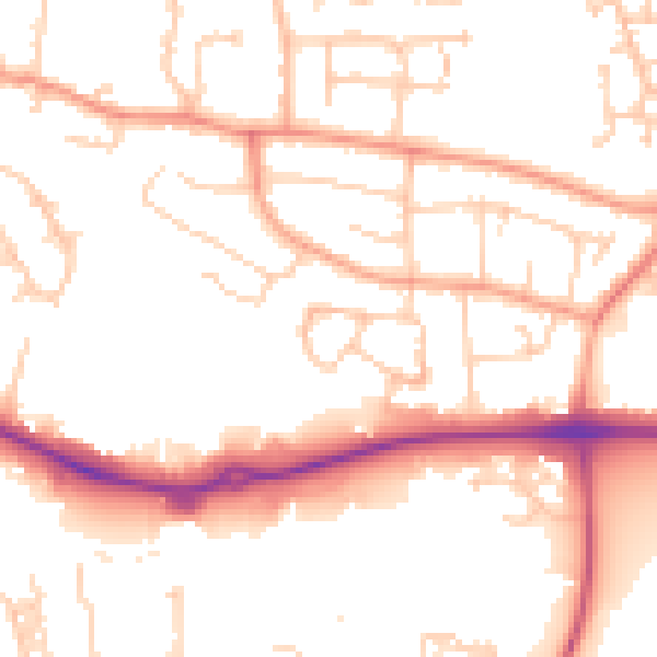
Daytime· 07:00 – 23:00
52.2dB

Night-time· 23:00 – 07:00
42.4dB