81 St Andrews Road, Southsea, PO5 1ES
About 81 St Andrews Road
81 St Andrews Road is a four-bedroom mid-terrace house in Southsea (PO5 1ES). It has a recorded floor area of 173 m² (around 1862 sq ft), construction records dating it to 1900-1929 and council tax band D. The latest certificate (May 2022) shows a D (score 58), a step below the typical UK home. When first surveyed in January 2014 the rating was E, the property has climbed 1 band since. Between certificates, window efficiency went from Poor to Average, hot-water efficiency went from Average to Good and lighting went from Very Poor to Good; while wall efficiency dropped from Good to Poor and roof efficiency dropped from Average to Very Poor. Period features are noted in the property record. Records show the property has been extended at some point in its history.
At 173 m² the property is well over the postcode median (55 m² across 37 EPCs), placing it in the larger end of the local stock. Across 2014–2021, sale prices on this property compounded at 10.3% per year. On a £-per-square-foot basis, the last sale (£295/sq ft) was about 149.1% above the typical sold price in the postcode. Last sale on file: £550,000 in June 2021. That sale was during the post-pandemic price surge, when transactions cleared materially above pre-2020 trend.
Know exactly what you're buying at 81 St Andrews Road
Before you offer, see what the listing won't tell you, the true value, the red flags and the full history.
Already flagged here
Launch offer · save £5
Valuation
against the asking price
Risks
planning & flood
Sold prices
similar homes nearby
Trends
the local market
What this property has
Inside
- Bedrooms4
- Bathrooms2
- Dining roomYes
- Utility roomYes
- CloakroomYes
- EnsuiteYes
- FireplaceYes
Outside
- Private gardenrear
Building
- Period featuresYes
- Previously extendedYes
- RefurbishedYes
Energy performance
81 St Andrews Road's carbon output runs well above what efficient homes in the postcode produce.
EPC Rating
Property Improvements
Changes detected from historical EPC data
Replaced storage heaters with gas boiler
Connected to mains gas supply
Heating controls upgraded for better temperature management
Hot water system upgraded
Windows upgraded, improving insulation
More low energy lighting installed
Solar PV panels (33 kWp) installed
Planning history
81 St Andrews Road has no planning applications on record.
Notable planning nearby
111applications of note in the surrounding area
We flagged 1 thing worth checking at 81 St Andrews Road
Independent checks surfaced things a buyer would want to understand before offering. The report explains each one in full, with the underlying data and what to ask.
- Signs of HMO activity in the area
30-day money-back guarantee
Sales history & valuation
Latest sale on 81 St Andrews Road was the highest on Land Registry record across the postcode.
£550,000
Modelled from EPC, postcode comparables and a sale-price growth of 10.3% per year over 7 years.
£550,000
Growth on file: 10.3% per year over 7 years.
Sales timeline
27 June 2021Most recent
£550,000
+102.2%over 7 years15 April 2014
£272,000
Median price across the last 5 sales in PO5 1ES: £153,000 (2025–2023).
Nearby sales in PO5 1ES
109a, St Andrews Road, Southsea, PO5 1ES
Sold Jun 2025
£145,000Lower Flat, 99 St Andrews Road, Southsea, PO5 1ES
Sold Mar 2024
£340,000109c, St Andrews Road, Southsea, PO5 1ES
Sold Sept 2023
£153,000101 St Andrews Road, Southsea, PO5 1ES
Sold Aug 2023
£410,000111c, St Andrews Road, Southsea, PO5 1ES
Sold Jul 2023
£146,000
Everything we know about 81 St Andrews Road, in one report
What it's really worth, what could be wrong, and the planning, sales and area data in full.
What we flagged
- Signs of HMO activity in the area

Versus other St Andrews Road homes
81 St Andrews Road outperforms the street on price per m² by a wide margin.
Price per m²
£3,179
Street avg £1,539
Floor Area
173 m²
Street avg 168 m²
Habitable Rooms
5 rooms
Street avg 8 rooms
CO₂ Emissions
6.8 t/year
Street avg 8.7 t/year
Similar properties nearby
1 Lorne Road
PO5 1RR
1 Boulton Road
PO5 1NS
1 Baileys Road
PO5 1EA
1 Livingstone Road
PO5 1RS
1 Chelsea Road
PO5 1NH
1 Grove Road North
PO5 1JJ
1 Goodwood Road
PO5 1NN
1 Montgomerie Road
PO5 1EB
The neighbourhood at a glance
Rail-style transport is unusually close for this postcode.
Crime
11/mo
Steady year-on-year across the wider district.
Nearest stop
0.1 km
Somers Road — bus stop.
Closest school
0.2 km
Ark Ayrton Primary Academy. 36 schools nearby.
Go deeper on the local area
The full report breaks down crime, transport links, schools and air quality in depth.
Road noise across the postcode
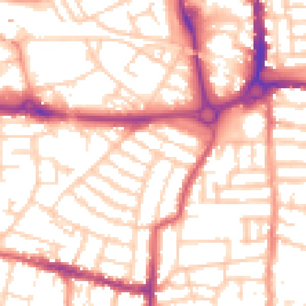
Daytime· 07:00 – 23:00
54.5dB

Night-time· 23:00 – 07:00
43.3dB