39 Bridgefoot Path, Emsworth, PO10 7EB
About 39 Bridgefoot Path
39 Bridgefoot Path is a two-bedroom mid-terrace house in Emsworth (PO10 7EB). It has a recorded floor area of 101 m² (around 1087 sq ft), construction records dating it to 1900-1929 and council tax band D. The latest certificate (October 2015) shows an E (score 54), well below the UK norm with real room to improve. The recommended improvements would lift it to C (score 80), a 2-band jump. The latest certificate is from October 2015, so improvements made since then won't be reflected. Our model identifies extension potential, subject to local planning policy. The home occupies a cul-de-sac position.
4 planning records sit against the property, 1 approved, 1 refused. Past consents include an extension, meaningful when judging how the property has evolved. The record references conservation-area consent, which constrain future alterations. It lags the bulk of the postcode on energy efficiency (less efficient than 75% of similar EPCs). Last sold in March 2016, so it's been off the market for around 10 years. Across 2005–2016, sale prices on this property compounded at 6% per year. Today's modelled estimate of £554,000 is 11.9% above the 2016 sale price.
Know exactly what you're buying at 39 Bridgefoot Path
Before you offer, see what the listing won't tell you, the true value, the red flags and the full history.
Already flagged here
Launch offer · save £5
Valuation
against the asking price
Risks
planning & flood
Sold prices
similar homes nearby
Trends
the local market
What this property has
Inside
- Bedrooms2
- Bathrooms1
Outside
- Private gardenrear
- Cul-de-sacYes
Building
- Extension potentialPossible
Energy performance
Recommended upgrades on file would lift this property by multiple EPC bands.
EPC Expired
This certificate is over 10 years old and is no longer valid.Expired 05 Oct 2025
EPC Rating
Planning history
39 Bridgefoot Path has an approved single-storey rear extension on the planning record.
- Oct 2024Tree WorksTreesIn report
Fell 1No. Birch within Conservation Area of Emsworth.
- Agent
- Michael Reed & Co Tree Service Ltd
Conservation Area- Documents
- 5 docs on file
- Reference
- APP/23/00656
- Mar 2020Tree WorksTreesIn report
Crown reduce 1No Silver Birch by 2m to leave 8m height and 6m spread to remain, within Conservation Area of Emsworth.
- Agent
- M Reed & Co Ltd
Conservation Area- Documents
- 6 docs on file
- Reference
- APP/20/00167
We flagged 1 thing worth checking at 39 Bridgefoot Path
Independent checks surfaced things a buyer would want to understand before offering. The report explains each one in full, with the underlying data and what to ask.
- Larger development activity nearby
30-day money-back guarantee
Sales history & valuation
£554,000
Modelled from EPC, postcode comparables and a sale-price growth of 6.0% per year over 11 years.
£495,000
Growth on file: 6.0% per year over 11 years.
Sales timeline
29 March 2016Most recent
£495,000
+32.4%over 9 years8 February 2007
£374,000
+41.1%over 1 year7 July 2005
£265,000
Median price across the last 5 sales in PO10 7EB: £652,000 (2025–2022).
Nearby sales in PO10 7EB
Everything we know about 39 Bridgefoot Path, in one report
What it's really worth, what could be wrong, and the planning, sales and area data in full.
What we flagged
- Larger development activity nearby

Versus other Bridgefoot Path homes
39 Bridgefoot Path is notably below the street on epc rating.
Price per m²
£4,901
Street avg £5,198
Floor Area
101 m²
Street avg 109 m²
Habitable Rooms
4 rooms
Street avg 5 rooms
CO₂ Emissions
5.3 t/year
Street avg 4.9 t/year
Similar properties nearby
1 Chequers Quay, 37 Queen Street
PO10 7AD
1 Bridgefoot Path
PO10 7EA
1 Bath Road
PO10 7EP
1 Churchill Drive
PO10 7SL
1 Birch Tree Drive
PO10 7RS
1 Bullfinch Close, Brushwood Grove
PO10 7GX
1 Barwell Grove
PO10 7XY
1 Bridge Road
PO10 7DT
The neighbourhood at a glance
Rail-style transport is unusually close for this postcode.
Crime
2/mo
Steady year-on-year across the wider district.
Nearest stop
0.2 km
The Square — bus stop.
Closest school
1.0 km
Emsworth Primary School. 9 schools nearby.
Go deeper on the local area
The full report breaks down crime, transport links, schools and air quality in depth.
Road noise across the postcode
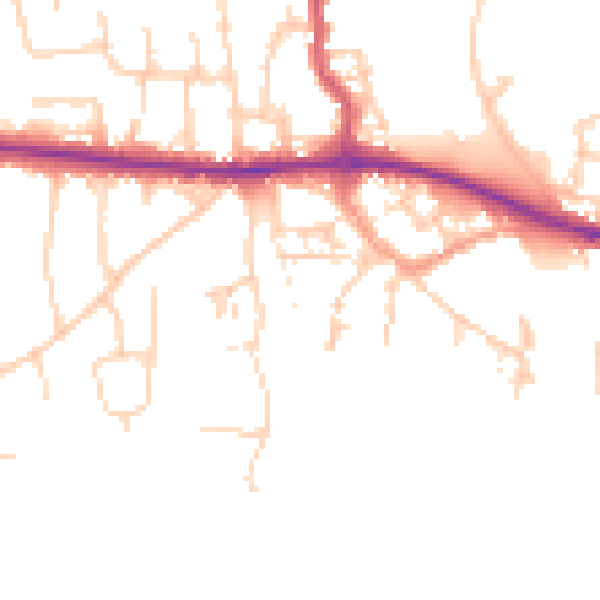
Daytime· 07:00 – 23:00
48.9dB

Night-time· 23:00 – 07:00
40.8dB