3 Clarendon Place, Portsmouth, PO1 4JG
About 3 Clarendon Place
3 Clarendon Place is a mid-terrace house in Portsmouth (PO1 4JG). It has a recorded floor area of 103 m² (around 1109 sq ft), construction records dating it to 1967-1975 and council tax band B. The latest certificate (November 2014) shows a C (score 70). The recommended improvements would push it to B (score 88). The latest certificate is from November 2014, so improvements made since then won't be reflected.
Untraded for 24 years, with the last transfer in April 2002. Across 2000–2002, sale prices on this property compounded at 31.1% per year. Today's modelled estimate of £222,000 sits 133.7% above the 2002 sale of £95,000. On a £-per-square-foot basis, the last sale (£86/sq ft) was about 16.2% below the postcode norm. At 103 m² it's 17.6% smaller than the typical home in the postcode (125 m² median across 3 EPCs).
Everything you need to know about 3 Clarendon Place
The true value, the hidden risks and the full sale history, in one report.
Pick your report · every report is £14.99
One time fee only - money back guarantee

The data behind every report


Energy performance
3 Clarendon Place's EPC is over a decade old — improvements since won't be reflected.
EPC Expired
This certificate is over 10 years old and is no longer valid.Expired 05 Nov 2024
EPC Rating
Get a survey for this property
Level 2 HomeBuyer Report
We've checked 10 risk factors against the available data for this property and believe a Level 2 HomeBuyer Report could be a suitable option for you.
From £545 · Includes VAT
Planning history
3 Clarendon Place has no planning applications on record.
But the area is active
2 notable applications nearby — larger schemes and conversions that could reshape the street. The report maps them all.
Sales history & valuation
3 Clarendon Place's estimated value is more than triple its earliest registered sale price (2000).
£222,000
Modelled from EPC, postcode comparables and a sale-price growth of 31.1% per year over 2 years.
£95,000
Growth on file: 31.1% per year over 2 years.
Sales timeline
25 April 2002Most recent
£95,000
+58.3%over 1 year13 August 2000
£60,000
Median price across the last 5 sales in PO1 4JG: £132,000 (2019–2000).
Versus other Clarendon Place homes
On floor area, 3 Clarendon Place runs well behind the street norm.
EPC Rating
70 (C)
Street avg 63 (D)
Floor Area
103 m²
Street avg 133 m²
CO₂ Emissions
3.2 t/year
Street avg 5.2 t/year
Habitable Rooms
5 rooms
Street avg 6 rooms
Everything you need to know about 3 Clarendon Place
The true value, the hidden risks and the full sale history, in one report.
Pick your report · every report is £14.99
One time fee only - money back guarantee
The data behind every report
Similar properties nearby
The neighbourhood at a glance
Rail-style transport is unusually close for this postcode.
Crime
9/mo
Steady year-on-year across the wider district.
Nearest stop
0.2 km
Clarendon Street — bus stop.
Closest school
0.3 km
The Portsmouth Academy. 45 schools nearby.
Go deeper on the local area
A Local Area report breaks down crime, transport links, schools and air quality in depth.
Road noise across the postcode
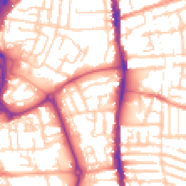
Daytime· 07:00 – 23:00
55.2dB

Night-time· 23:00 – 07:00
44.2dB