13 Chestnut Road, Oxford, OX2 9EA
About 13 Chestnut Road
13 Chestnut Road is a one-bedroom detached house in Oxford (OX2 9EA). It has a recorded floor area of 38 m² (around 409 sq ft) and council tax band B. The latest certificate (November 2018) shows a D (score 63), on the cusp of jumping into the C band. When first surveyed in November 2018 the rating was E, the property has climbed 1 band since. Main heating runs on electricity: electricity, unspecified tariff. At 38 m² this is the 2nd smallest of 24 units on EPC record in the building, where floor areas span 36–142 m². The building's EPC ratings span E to C across 24 units on file.
At 38 m² it sits well below the postcode median (75 m² across 23 EPCs), making it one of the more compact homes locally. Across 2005–2015, sale prices on this property compounded at -2.2% per year. Today's modelled estimate of £198,000 is 35.6% above the 2015 sale price. On a £-per-square-foot basis, the last sale (£357/sq ft) was about 28.6% above the typical sold price in the postcode. Last changed hands 12 years ago, in February 2015. One historical planning record sits against the property in 2005.
What this property has
Inside
- Bedrooms1
Everything you need to know about 13 Chestnut Road
The true value, the hidden risks and the full sale history, in one report.
Pick your report · from £14.99
One time fee only - money back guarantee

The data behind every report







Energy performance
EPC Rating
Certificate validity
Valid until 14 November 2028
Property Improvements
Changes detected from historical EPC data

Get a survey for this property
Level 2 HomeBuyer Report
We've checked 10 risk factors against the available data for this property and believe a Level 2 HomeBuyer Report could be a suitable option for you.
From £495 · Includes VAT
Planning history
Council records show a subdivision application — the property's legal arrangement has been altered.
1 application on record at 13 Chestnut Road, Oxford, OX2 9EA
- Nov 2005SubdivisionOutcome in report
Conversion of existing dwelling to form 1 x 2 bed flat and 1 x 1 bed flat with associated parking.
- Documents
- 2 docs on file
- Reference
- P05/V1461
Unlock 13 Chestnut Road, Oxford, OX2 9EA's full planning history
You're seeing the shape of it. The report has the substance.
- Every decision — granted, refused or withdrawn (1 on record)
- All 1 application on this property in full, plus 12 notable nearby
- The 2 documents, officer reports & conditions
- What the pattern means for extending or converting here
One time fee only - money back guarantee
Sales history & valuation
£198,000
Modelled from EPC, postcode comparables and a sale-price growth of -2.2% per year over 9 years.
£146,000
Growth on file: -2.2% per year over 9 years.
Sales timeline
6 February 2015Most recent
£146,000
-18.9%over 9 years20 September 2005
£180,000
Median price across the last 5 sales in OX2 9EA: £399,999 (2025–2018).
Versus other Chestnut Road homes
On price per m², 13 Chestnut Road runs well behind the street norm.
Price per m²
£3,842
Street avg £5,102
Floor Area
38 m²
Street avg 52 m²
CO₂ Emissions
1.9 t/year
Street avg 2.2 t/year
Years Held
12 years
Street avg 10 years
Everything you need to know about 13 Chestnut Road
The true value, the hidden risks and the full sale history, in one report.
Pick your report · from £14.99
One time fee only - money back guarantee
The data behind every report
Similar properties nearby
1 Cherry Tree Court, Chestnut Road
OX2 9EP
1 Breeches End, Cumnor Hill
OX2 9FW
1 Church Close, Farmoor
OX2 9NP
1 Bushy Close
OX2 9SH
1 Cumnor Road, Farmoor
OX2 9NS
1 Beech Road, Botley
OX2 9EF
1 Deanfield Road
OX2 9DW
1 Chawley Lane, Cumnor
OX2 9PX
The neighbourhood at a glance
Daytime road noise here sits well below conversation level — a quiet pocket of the postcode.
Crime
155/mo
Steady year-on-year across the wider district.
Nearest stop
0.1 km
Laburnum Road Shops — bus stop.
Closest school
0.5 km
Matthew Arnold School. 9 schools nearby.
Go deeper on the local area
A Local Area report breaks down crime, transport links, schools and air quality in depth.
Road noise across the postcode
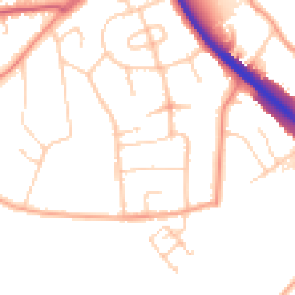
Daytime· 07:00 – 23:00
49.5dB

Night-time· 23:00 – 07:00
40.6dB