1 Ash Walk, Chadderton, Oldham, OL9 0JP
About 1 Ash Walk
1 Ash Walk is an end-of-terrace house in Chadderton, Oldham, Oldham (OL9 0JP). It has a recorded floor area of 50 m² (around 535 sq ft), construction records dating it to 1950-1966 and council tax band A. The latest certificate (February 2009) shows a D (score 68), on the cusp of jumping into the C band. The latest certificate is from February 2009, so improvements made since then won't be reflected.
Everything you need to know about 1 Ash Walk
The true value, the hidden risks and the full sale history, in one report.
Pick your report · every report is £14.99
One time fee only - money back guarantee

The data behind every report


Energy performance
1 Ash Walk's EPC is over a decade old — improvements since won't be reflected.
EPC Expired
This certificate is over 10 years old and is no longer valid.Expired 23 Feb 2019
EPC Rating
Get a survey for this property
Level 2 HomeBuyer Report
We've checked 10 risk factors against the available data for this property and believe a Level 2 HomeBuyer Report could be a suitable option for you.
From £495 · Includes VAT
Planning history
1 Ash Walk has no planning applications on record.
But the area is active
2 notable applications nearby — larger schemes and conversions that could reshape the street. The report maps them all.
Sales history & valuation
1 Ash Walk has no Land Registry sales on file, suggesting it has stayed in the same hands since registration began.
£161,000
Modelled from EPC, postcode comparables.
No sales recorded with HM Land Registry
That can mean the property has never traded since the registry began publishing in 1995, was a new build that hasn't been registered yet, or is held in the same hands long-term.
Versus other Ash Walk homes
Habitable Rooms for 1 Ash Walk lags the street by a wide margin.
EPC Rating
68 (D)
Street avg 66 (D)
Floor Area
50 m²
Street avg 51 m²
CO₂ Emissions
2.3 t/year
Street avg 2.5 t/year
Habitable Rooms
3 rooms
Street avg 4 rooms
Everything you need to know about 1 Ash Walk
The true value, the hidden risks and the full sale history, in one report.
Pick your report · every report is £14.99
One time fee only - money back guarantee
The data behind every report
Similar properties nearby
1 Eustace Street, Chadderton
OL9 0DZ
1 Briar Grove, Chadderton
OL9 0EH
1 Cypress Avenue, Chadderton
OL9 0JS
1 Butterworth Street, Chadderton
OL9 0JL
1 Fir Grove, Chadderton
OL9 0DJ
1 Alasdair Close, Chadderton
OL9 0NE
1 Clevedon Road, Chadderton
OL9 0AH
1 Daisy Street, Chadderton
OL9 0LB
The neighbourhood at a glance
Crime
1/mo
Steady year-on-year across the wider district.
Nearest stop
0.0 km
Burnley Street — bus stop.
Closest school
0.3 km
Bare Trees Primary School. 45 schools nearby.
Go deeper on the local area
A Local Area report breaks down crime, transport links, schools and air quality in depth.
Road noise across the postcode
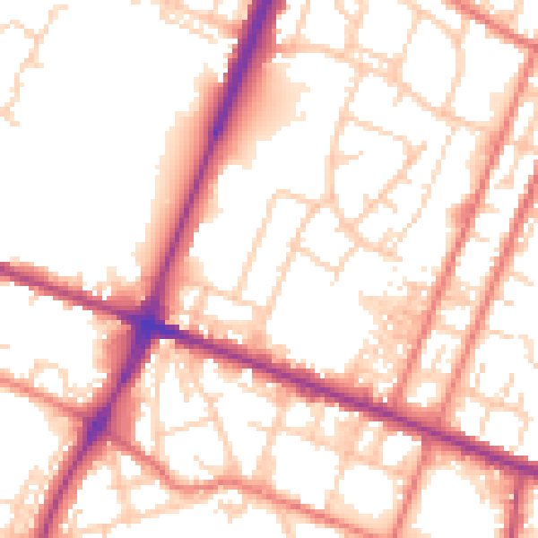
Daytime· 07:00 – 23:00
54.4dB

Night-time· 23:00 – 07:00
44.7dB