12 Bruce Street, Rochdale, OL11 3NH
About 12 Bruce Street
12 Bruce Street is an end-of-terrace house in Rochdale (OL11 3NH). It has a recorded floor area of 50 m² (around 538 sq ft), construction records dating it to 1976-1982 and council tax band A. At 50 m² this is the 15th smallest of 27 units on EPC record in the building, where floor areas span 42–125 m². The building's EPC ratings span E to C, with this unit at the top. The latest certificate (February 2017) shows a C (score 76), near the top of the C band.
Across 2002–2022, sale prices on this property compounded at 5.7% per year. Today's modelled estimate of £111,000 is 41.4% above the 2022 sale price. On a £-per-square-foot basis, the last sale (£146/sq ft) was about 35.3% above the typical sold price in the postcode. Last sale on file: £78,500 in June 2022. That sale was during the post-pandemic price surge, when transactions cleared materially above pre-2020 trend.
Everything you need to know about 12 Bruce Street
The true value, the hidden risks and the full sale history, in one report.
30-day money-back guarantee

The data behind every report


Energy performance
EPC Rating
Planning history
12 Bruce Street has no planning applications on record.
Notable planning nearby
4applications of note in the surrounding area
We flagged 1 thing worth checking at 12 Bruce Street
Independent checks surfaced things a buyer would want to understand before offering. The report explains each one in full, with the underlying data and what to ask.
- Signs of HMO activity in the area
30-day money-back guarantee
Sales history & valuation
12 Bruce Street has more than tripled in price since its earliest registered sale in 2002.
£111,000
Modelled from EPC, postcode comparables and a sale-price growth of 5.7% per year over 20 years.
£78,500
Growth on file: 5.7% per year over 20 years.
Sales timeline
23 June 2022Most recent
£78,500
+67.0%over 18 years29 April 2004
£47,000
+80.8%over 1 year25 June 2002
£26,000
Median price across the last 5 sales in OL11 3NH: £200,000 (2025–2022).
Nearby sales in OL11 3NH
Versus other Bruce Street homes
12 Bruce Street is notably below the street on years held.
Price per m²
£1,570
Street avg £1,255
Floor Area
50 m²
Street avg 47 m²
Habitable Rooms
2 rooms
Street avg 2 rooms
CO₂ Emissions
1.6 t/year
Street avg 1.8 t/year
Everything you need to know about 12 Bruce Street
The true value, the hidden risks and the full sale history, in one report.
30-day money-back guarantee
The data behind every report
Similar properties nearby
The neighbourhood at a glance
Crime
1/mo
Steady year-on-year across the wider district.
Nearest stop
0.1 km
Sudden Street — bus stop.
Closest school
0.4 km
Marland Hill Community Primary School. 31 schools nearby.
Go deeper on the local area
The full report breaks down crime, transport links, schools and air quality in depth.
Road noise across the postcode
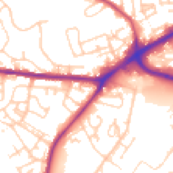
Daytime· 07:00 – 23:00
54.4dB

Night-time· 23:00 – 07:00
46.1dB