Are you a property professional?Get qualified leads from motivated homeowners.
Get started48a, Blenheim Gardens, Brent, London, NW2 4NS
1 planning record
About 48a
A plain-English summary derived from public records, EPC certificates, sold prices and local data.
48a is a three-bedroom detached house in Brent, London, London (NW2 4NS). It has a recorded floor area of 106 m² (around 1137 sq ft), construction records dating it to 1950-1966 and council tax band D. At 106 m² this is the 13th smallest of 20 units on EPC record in the building, where floor areas span 35–249 m². The building's EPC ratings span F to C across 20 units on file. The latest certificate (May 2011) shows a D (score 57), a step below the typical UK home. The latest certificate is from May 2011, so improvements made since then won't be reflected.
Untraded for 27 years, with the last transfer in July 1999. Only one transfer is on record with HM Land Registry, suggesting it has stayed in the same hands for a long time. At 106 m² the property is well over the postcode median (75 m² across 32 EPCs), placing it in the larger end of the local stock. Today's modelled estimate of £700,000 sits 120.8% above the 1999 sale of £317,000. On a £-per-square-foot basis, the last sale (£279/sq ft) was about 31.6% below the postcode norm. One planning record on file: subdivision approved in 2016. Past consents include subdivision, meaningful when judging how the property has evolved.
What this property has
Pulled from EPC certificates, claim submissions and our property model. Empty categories are hidden — we only show what's known.
Inside
- Bedrooms3
Energy performance
Every EPC certificate filed against this property — current rating, recorded improvements, and where there's headroom to reach a higher band.
48a's carbon output runs well above what efficient homes in the postcode produce.
EPC Expired
This certificate is over 10 years old and is no longer valid.Expired 04 May 2021
Planning history
Applications and permits filed against 48a, Blenheim Gardens, Brent, London, NW2 4NS, sourced from the PlanIt planning register.
Council records show a subdivision application — the property's legal arrangement has been altered.
- Aug 2016SubdivisionFullGrant Permission
Conversion of two existing self-contained flats into a single family dwellinghouse
Sales history & valuation
Recorded transactions, our model's current estimate, and a quick read on what neighbouring properties have sold for.
48a has been held in the same hands since before 2000.
Current estimate
See how we calculated this£700,000
Modelled from EPC, postcode comparables.
Last sold (1999)
£317,000
Recorded with HM Land Registry.
Sales timeline
Versus other Blenheim Gardens homes
Four headline reads against 31 similar flats on this street, drawn from the latest EPC and Land Registry data.
CO₂ Emissions for 48a lags the street by a wide margin.
Price per m²
£3,000
Street avg £5,994
Floor Area
106 m²
Street avg 74 m²
Habitable Rooms
5 rooms
Street avg 3 rooms
Similar properties nearby
A handful of close matches in the same postcode area, ranked by likeness on bedrooms, type and floor area.
The neighbourhood at a glance
A condensed read of the local area. Each tile links through to the full breakdown on the London district page.
Rail-style transport is unusually close for this postcode.
Crime
14/mo
Rising year-on-year across the wider district.
Nearest stop
0.2 km
Willesden Green Underground Station — subway entrance.
Road noise across the postcode
Modelled day and night-time noise levels around NW2 4NS from Defra's strategic mapping. The pin marks this postcode's centroid.
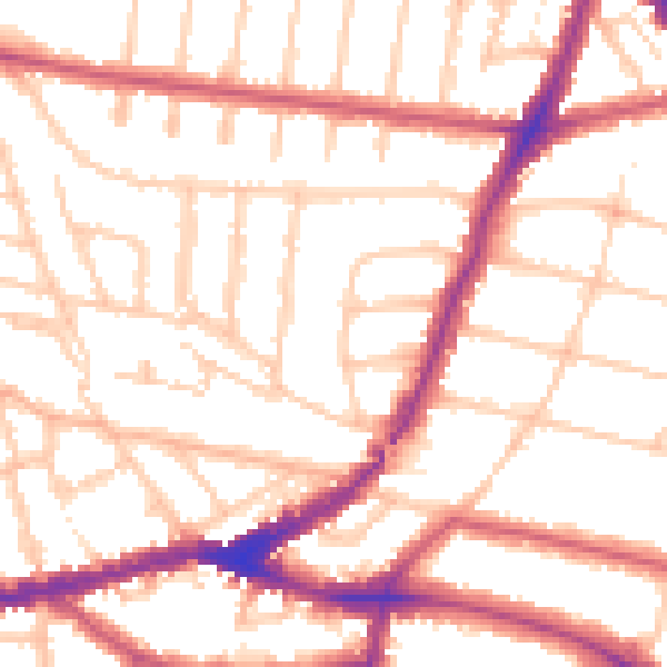
Daytime· 07:00 – 23:00
52.7dB

Everything within walking distance
Schools, transport stops and scenic spots near this property — 97 points of interest in total.
Beautiful places to visit nearby
Curated scenic spots within reach of this postcode, served by Beautifulplaces.ai. Photography and tagging come from their open dataset.
Common questions
The questions buyers, sellers and homeowners most often ask about 48a, Blenheim Gardens, Brent, London, NW2 4NS. Each answer is also embedded as structured data for search engines.