The Vicarage, High Street, Rothwell, Kettering, NN14 6BQ
About The Vicarage
The Vicarage is a detached house in Rothwell, Kettering, Kettering (NN14 6BQ). It has a recorded floor area of 201 m² (around 2164 sq ft) and construction records dating it to 1967-1975. The latest certificate (February 2025) shows a D (score 66), on the cusp of jumping into the C band. The rating has held steady at D across 2 certificates since December 2008. Between certificates, roof efficiency went from Poor to Very Good and lighting went from Average to Very Good; while wall efficiency dropped from Good to Average and window efficiency dropped from Good to Average. The recommended improvements would push it to C (score 75).
At 201 m² the property is well over the postcode median (56 m² across 10 EPCs), placing it in the larger end of the local stock. 4 planning records sit against the property, 0 approved, 0 refused.
Everything you need to know about The Vicarage
The true value, the hidden risks and the full sale history, in one report.
Pick your report · from £14.99
One time fee only - money back guarantee

The data behind every report





Energy performance
The Vicarage's carbon output runs well above what efficient homes in the postcode produce.
EPC Rating
Certificate validity
Valid until 20 February 2035
Property Improvements
Changes detected from historical EPC data
Heating controls upgraded for better temperature management
Loft insulation upgraded to recommended levels
More low energy lighting installed

Get a survey for this property
Level 2 HomeBuyer Report
We've checked 10 risk factors against the available data for this property and believe a Level 2 HomeBuyer Report could be a suitable option for you.
From £695 · Includes VAT
Planning history
Planning history at The Vicarage is exclusively tree-management applications — typical for a property with mature trees on or near the plot.
4 applications on record at The Vicarage, High Street, Rothwell, Kettering, NN14 6BQ
- Jul 2007Tree WorksTreesOutcome in report
Works to trees within conservation area as follows: 1. Walnut Tree - Remove two lowest branches; 2. Conifer Tree - Fell and poison; 3. Holly Tree - Remove one limb and prune away from fence; 4. Holly Tree - fell and poison; 5. Damson Tree - Fell and poison; 6. Elder Bush - Fell and poison;7. Apple Tree - Look at health of tree as there may be a fungal infection; 8. Conifer Tree - Fell;9. Pine Tree - Remove ivy and dead wood; 10. Group of Elder Trees - Fell and poison; 11. Pine Tree - Remove ivy, tidy broken branch and cut back from building;12. Goat Willow Tree - Attend to any necessary maintenance by removing two or three lower branches and generally reduce size (15-20%); 13. Spruce Tree - Fell; 14. Cherry Tree - Fell and poison.
- Documents
- 2 docs on file
- Reference
- KET/2007/0512
- More recent applications — locked
- Tree WorksMay 2024Decision
- Tree WorksJan 2024Decision
+ 1 more application in the report
Unlock The Vicarage, High Street, Rothwell, Kettering, NN14 6BQ's full planning history
You're seeing the shape of it. The report has the substance.
- Every decision — granted, refused or withdrawn (3 on record)
- All 4 applications on this property in full, plus 3 notable nearby
- The 14 documents, officer reports & conditions
- What the pattern means for extending or converting here
One time fee only - money back guarantee
Sales history & valuation
The Vicarage has no Land Registry sales on file, suggesting it has stayed in the same hands since registration began.
£478,000
Modelled from EPC, postcode comparables.
No sales recorded with HM Land Registry
That can mean the property has never traded since the registry began publishing in 1995, was a new build that hasn't been registered yet, or is held in the same hands long-term.
Median price across the last 4 sales in NN14 6BQ: £315,000 (2025–1999).
Everything you need to know about The Vicarage
The true value, the hidden risks and the full sale history, in one report.
Pick your report · from £14.99
One time fee only - money back guarantee
The data behind every report
Similar properties nearby
1 Burditt Close, Rothwell
NN14 6LD
1 Adams Drive, Rothwell
NN14 6YB
1 Barn Owl Drive, Rothwell
NN14 6FR
1 Clipstone Court, Rothwell
NN14 6JX
1 Beverley Close, Rothwell
NN14 6EN
1 Butlin Close, Rothwell
NN14 6YA
1 Ashgate Court, School Lane, Rothwell
NN14 6HZ
1 Barlow Close, Rothwell
NN14 6YD
The neighbourhood at a glance
Crime
172/mo
Falling year-on-year across the wider district.
Nearest stop
0.0 km
War Memorial — bus stop.
Closest school
0.2 km
Rothwell Victoria Infant School. 7 schools nearby.
Go deeper on the local area
A Local Area report breaks down crime, transport links, schools and air quality in depth.
Road noise across the postcode
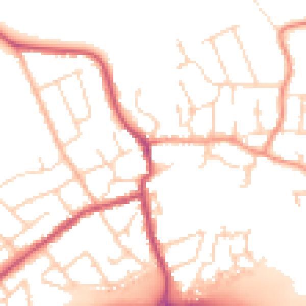
Daytime· 07:00 – 23:00
51.1dB

Night-time· 23:00 – 07:00
42.0dB