8 The Causeway, Byfield, Daventry, NN11 6XE
About 8 The Causeway
8 The Causeway is a property in Byfield, Daventry, Daventry (NN11 6XE). It has council tax band B.
Energy performance
No EPC on record
This property doesn't have an Energy Performance Certificate yet. An EPC is required to sell or let — and unlocks our automated valuation.
Planning history
No planning applications are recorded against 8 The Causeway, Byfield, Daventry, NN11 6XE. The full report also covers planning activity across the surrounding area.
Sales history & valuation
No sales recorded with HM Land Registry
That can mean the property has never traded since the registry began publishing in 1995, was a new build that hasn't been registered yet, or is held in the same hands long-term.
Median price across the last 5 sales in NN11 6XE: £285,000 (2025–2019).
Nearby sales in NN11 6XE
7 The Causeway, Byfield, Daventry, NN11 6XE
Sold Sept 2025
£300,0003 The Causeway, Byfield, Daventry, NN11 6XE
Sold Oct 2024
£285,00015 The Causeway, Byfield, Daventry, NN11 6XE
Sold Jul 2024
£115,0009 The Causeway, Byfield, Daventry, NN11 6XE
Sold Jun 2022
£305,00012 The Causeway, Byfield, Daventry, NN11 6XE
Sold Nov 2019
£208,000
Similar properties nearby
1 Appletree Farm Cottage, Appletree
NN11 6UG
1 Appletree Lane, Aston Le Walls
NN11 6TL
1 Banbury Lane, Byfield
NN11 6UX
1 Banbury Road, Byfield
NN11 6XJ
1 Becketts Close, Byfield
NN11 6XS
1 Bell Lane, Byfield
NN11 6US
1 Blackboy Cottage, Lower Shuckburgh
NN11 6DX
1 Boddington Court, Banbury Road, Lower Boddington
NN11 6XY
The neighbourhood at a glance
Daytime road noise here sits well below conversation level — a quiet pocket of the postcode.
Crime
2/mo
Steady year-on-year across the wider district.
Nearest stop
0.2 km
No28 — bus stop.
Closest school
0.8 km
Byfield School. 2 schools nearby.
Road noise across the postcode
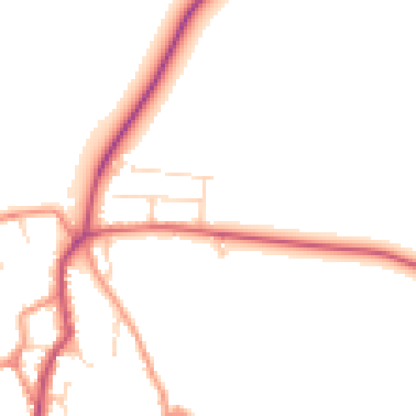
Daytime· 07:00 – 23:00
47.1dB

Night-time· 23:00 – 07:00
39.9dB