18 Central Avenue, Mapperley, Nottingham, NG3 5LD
About 18 Central Avenue
18 Central Avenue is a property in Mapperley, Nottingham, Nottingham (NG3 5LD). It has council tax band C.
Untraded for 21 years, with the last transfer in October 2005.
Everything you need to know about 18 Central Avenue
The true value, the hidden risks and the full sale history, in one report.
Pick your report · every report is £14.99
One time fee only - money back guarantee

The data behind every report


Energy performance
No EPC on record
This property doesn't have an Energy Performance Certificate yet. An EPC is required to sell or let — and unlocks our automated valuation.
Get a survey for this property
Level 2 HomeBuyer Report
We've checked 10 risk factors against the available data for this property and believe a Level 2 HomeBuyer Report could be a suitable option for you.
Planning history
18 Central Avenue has no planning applications on record.
But the area is active
4 notable applications nearby — larger schemes and conversions that could reshape the street. The report maps them all.
Sales history & valuation
£186,950
Recorded with HM Land Registry.
Sales timeline
20 October 2005Most recent
£186,950
Median price across the last 5 sales in NG3 5LD: £240,000 (2022–2011).
Nearby sales in NG3 5LD
4 Central Avenue, Mapperley, Nottingham, NG3 5LD
Sold Dec 2022
£370,00010 Central Avenue, Mapperley, Nottingham, NG3 5LD
Sold Jan 2022
£344,0006 Central Avenue, Mapperley, Nottingham, NG3 5LD
Sold Sept 2017
£240,00014 Central Avenue, Mapperley, Nottingham, NG3 5LD
Sold Jun 2017
£220,00016 Central Avenue, Mapperley, Nottingham, NG3 5LD
Sold Jun 2003
£165,000
Everything you need to know about 18 Central Avenue
The true value, the hidden risks and the full sale history, in one report.
Pick your report · every report is £14.99
One time fee only - money back guarantee
The data behind every report
Similar properties nearby
1 Birkland Avenue, Mapperley
NG3 5LA
1 Bonington Road
NG3 5JR
1 Berkeley Avenue
NG3 5BU
1 Braunton Crescent, Mapperley
NG3 5SZ
1 Bailey Drive
NG3 5US
1 Carisbrooke Avenue
NG3 5DT
1 Axmouth Drive, Mapperley
NG3 5SX
1 Ashwater Drive
NG3 5SJ
The neighbourhood at a glance
Reported crime in the wider district is trending notably upward year-on-year.
Crime
5/mo
Rising year-on-year across the wider district.
Nearest stop
0.1 km
Newbury Close — bus stop.
Closest school
0.0 km
Mapperley Plains Primary and Nursery School. 42 schools nearby.
Go deeper on the local area
A Local Area report breaks down crime, transport links, schools and air quality in depth.
Road noise across the postcode
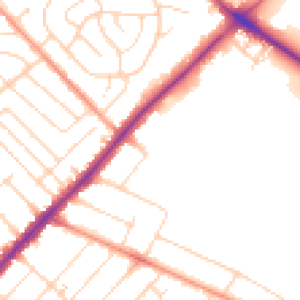
Daytime· 07:00 – 23:00
49.4dB

Night-time· 23:00 – 07:00
40.7dB