210a, North Sherwood Street, Nottingham, NG1 4EN
About 210a
210a is a six-bedroom end-of-terrace house in Nottingham (NG1 4EN). It has a recorded floor area of 124 m² (around 1335 sq ft), construction records dating it to 1996-2002 and council tax band C. The latest certificate (June 2019) shows a C (score 79), near the top of the C band. When first surveyed in August 2009 the rating was D, the property has climbed 1 band since. Between certificates, lighting went from Poor to Very Good. At 124 m² this is the 33rd smallest of 39 units on EPC record in the building, where floor areas span 44–175 m². The building's EPC ratings span D to B across 39 units on file.
Untraded for 26 years, with the last transfer in August 2000. Only one transfer is on record with HM Land Registry, suggesting it has stayed in the same hands for a long time. At 124 m² the property is well over the postcode median (82 m² across 38 EPCs), placing it in the larger end of the local stock. Today's modelled estimate of £201,000 sits 704% above the 2000 sale of £25,000. On a £-per-square-foot basis, the last sale (£19/sq ft) was about 90.8% below the postcode norm.
What this property has
Inside
- Bedrooms6
- Bathrooms2
Outside
- Private gardenYes
Building
- Central heatingYes
- RefurbishedYes
Everything you need to know about 210a
The true value, the hidden risks and the full sale history, in one report.
Pick your report · every report is £14.99
One time fee only - money back guarantee

The data behind every report


Energy performance
EPC Rating
Property Improvements
Changes detected from historical EPC data
Heating controls upgraded for better temperature management
Wall insulation upgraded
More low energy lighting installed
Get a survey for this property
Level 2 HomeBuyer Report
We've checked 10 risk factors against the available data for this property and believe a Level 2 HomeBuyer Report could be a suitable option for you.
From £545 · Includes VAT
Planning history
210a has no planning applications on record.
But the area is active
16 notable applications nearby — larger schemes and conversions that could reshape the street. The report maps them all.
Sales history & valuation
Latest sale on 210a was the lowest on Land Registry record across the postcode.
£201,000
Modelled from EPC, postcode comparables.
£25,000
Recorded with HM Land Registry.
Sales timeline
14 August 2000Most recent
£25,000
Median price across the last 5 sales in NG1 4EN: £242,425 (2022–2006).
Nearby sales in NG1 4EN
262 North Sherwood Street, Nottingham, NG1 4EN
Sold Mar 2022
£350,000260 North Sherwood Street, Nottingham, NG1 4EN
Sold Mar 2022
£420,000240 North Sherwood Street, Nottingham, NG1 4EN
Sold Jul 2006
£242,425244 North Sherwood Street, Nottingham, NG1 4EN
Sold Jul 2006
£242,425242 North Sherwood Street, Nottingham, NG1 4EN
Sold Jul 2006
£242,425
Versus other North Sherwood Street homes
On price per m², 210a runs well behind the street norm.
Price per m²
£202
Street avg £2,601
Floor Area
124 m²
Street avg 79 m²
Habitable Rooms
7 rooms
Street avg 5 rooms
CO₂ Emissions
2.7 t/year
Street avg 1.6 t/year
Everything you need to know about 210a
The true value, the hidden risks and the full sale history, in one report.
Pick your report · every report is £14.99
One time fee only - money back guarantee
The data behind every report
Similar properties nearby
The neighbourhood at a glance
Rail-style transport is unusually close for this postcode.
Crime
39/mo
Rising year-on-year across the wider district.
Nearest stop
0.1 km
Forest Road — bus stop.
Closest school
0.6 km
Huntingdon Academy. 43 schools nearby.
Go deeper on the local area
A Local Area report breaks down crime, transport links, schools and air quality in depth.
Road noise across the postcode
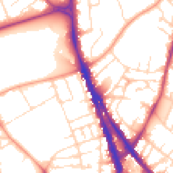
Daytime· 07:00 – 23:00
53.9dB
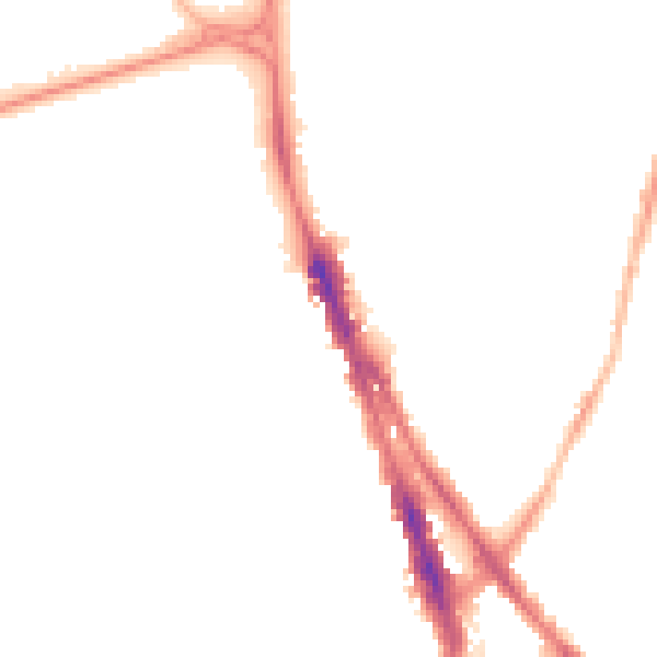
Night-time· 23:00 – 07:00
43.7dB