11 Carter Gate, Nottingham, NG1 1GL
About 11 Carter Gate
11 Carter Gate is a two-bedroom mid-terrace house in Nottingham (NG1 1GL). It has a recorded floor area of 73 m² (around 786 sq ft), construction records dating it to 1967-1975 and council tax band A. The latest certificate (July 2023) shows a D (score 65), on the cusp of jumping into the C band. The recommended improvements would lift it to B (score 89), a 2-band jump.
At 73 m² the property is well over the postcode median (56 m² across 48 EPCs), placing it in the larger end of the local stock. It lags the bulk of the postcode on energy efficiency (less efficient than 79% of similar EPCs). A recent sale: £150,000 in May 2025. Across 2024–2025, sale prices on this property compounded at 15.4% per year. Today's modelled estimate of £167,000 is 11.3% above the 2025 sale price. On a £-per-square-foot basis, the last sale (£191/sq ft) was about 22.2% above the typical sold price in the postcode.
What this property has
Inside
- Bedrooms2
- Bathrooms1
- Open-plan layoutYes
Outside
- Private gardenYes
- ParkingOff street
Building
- RefurbishedYes
Everything you need to know about 11 Carter Gate
The true value, the hidden risks and the full sale history, in one report.
Pick your report · every report is £14.99
One time fee only - money back guarantee

The data behind every report


Energy performance
Recommended upgrades on file would lift this property by multiple EPC bands.
EPC Rating
Get a survey for this property
Level 2 HomeBuyer Report
We've checked 10 risk factors against the available data for this property and believe a Level 2 HomeBuyer Report could be a suitable option for you.
From £495 · Includes VAT
Planning history
11 Carter Gate has no planning applications on record.
But the area is active
14 notable applications nearby — larger schemes and conversions that could reshape the street. The report maps them all.
Sales history & valuation
Latest sale on 11 Carter Gate was the highest on Land Registry record across the postcode.
£167,000
Modelled from EPC, postcode comparables and a sale-price growth of 15.4% per year over 1 year.
£150,000
Growth on file: 15.4% per year over 1 year.
Sales timeline
22 May 2025Most recent
£150,000
+15.4%over 12 months30 May 2024
£130,000
Median price across the last 5 sales in NG1 1GL: £125,000 (2024–2021).
Nearby sales in NG1 1GL
Versus other Carter Gate homes
Years Held for 11 Carter Gate lags the street by a wide margin.
Price per m²
£2,055
Street avg £1,759
Floor Area
73 m²
Street avg 75 m²
Habitable Rooms
3 rooms
Street avg 3 rooms
CO₂ Emissions
3.2 t/year
Street avg 2.9 t/year
Everything you need to know about 11 Carter Gate
The true value, the hidden risks and the full sale history, in one report.
Pick your report · every report is £14.99
One time fee only - money back guarantee
The data behind every report
Similar properties nearby
105 Cliff Road
NG1 1GT
10 Brightmoor Street
NG1 1FD
1 The Ice House, Belward Street
NG1 1JW
103 Cliff Road
NG1 1GT
1 Belward Street
NG1 1JZ
1 Park View Court, Bath Street
NG1 1DD
1 Halifax Place
NG1 1QN
107 Cliff Road
NG1 1GT
The neighbourhood at a glance
Rail-style transport is unusually close for this postcode.
Crime
39/mo
Rising year-on-year across the wider district.
Nearest stop
0.1 km
Bellar Gate — bus stop.
Closest school
0.3 km
Nottingham College. 39 schools nearby.
Go deeper on the local area
A Local Area report breaks down crime, transport links, schools and air quality in depth.
Road noise across the postcode
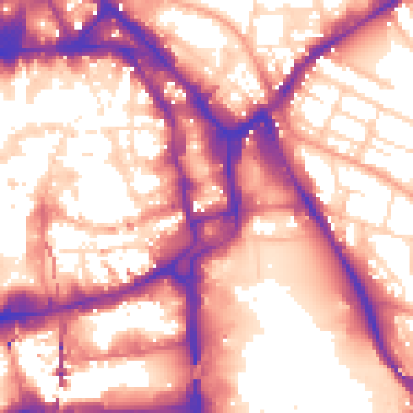
Daytime· 07:00 – 23:00
59.4dB

Night-time· 23:00 – 07:00
50.6dB