10 Victoria Mews, Newcastle Upon Tyne, NE2 1ER
About 10 Victoria Mews
10 Victoria Mews is a four-bedroom detached house in Newcastle Upon Tyne (NE2 1ER). It has a recorded floor area of 135 m² (around 1453 sq ft), construction records dating it to 1991-1995 and council tax band F. The latest certificate (December 2024) returns a B (score 82), comfortably above the UK average. When first surveyed in April 2011 the rating was D, the property has climbed 2 bands since. Between certificates, window efficiency went from Average to Good and lighting went from Very Poor to Very Good; while roof efficiency dropped from Good to Average and hot-water efficiency dropped from Very Good to Good.
On energy efficiency it sits in the top 10% of properties in this postcode. Last sale on file: £425,000 in August 2018. Across the public record there are 4 sales, relatively high churn for a single property. Across 1999–2018, sale prices on this property compounded at 5.7% per year. Today's modelled estimate of £567,000 is 33.4% above the 2018 sale price. On a £-per-square-foot basis, the last sale (£292/sq ft) was about 17.3% above the typical sold price in the postcode. One historical planning record sits against the property in 2026.
Know exactly what you're buying at 10 Victoria Mews
Before you offer, see what the listing won't tell you, the true value, the red flags and the full history.
Already flagged here
Valuation
against the asking price
Risks
planning & flood
Sold prices
similar homes nearby
Trends
the local market
What this property has
Inside
- Bedrooms4
- Bathrooms2
Energy performance
10 Victoria Mews ranks among the most efficient homes in the postcode for energy use.
EPC Rating
Property Improvements
Changes detected from historical EPC data
Hot water efficiency decreased
Loft insulation upgraded to recommended levels
More low energy lighting installed
Window efficiency improved
More low energy lighting installed
Planning history
- Apr 2026ExtensionFullIn report
Extension: Single storey · Front of property
Erection of a Single storey to front.
- Reference
- 2026/0623/01/HOU
We flagged 1 thing worth checking at 10 Victoria Mews
Independent checks surfaced things a buyer would want to understand before offering. The report explains each one in full, with the underlying data and what to ask.
- Signs of HMO activity in the area
30-day money-back guarantee
Sales history & valuation
10 Victoria Mews has more than doubled in price since the earliest registered sale in 1999.
£567,000
Modelled from EPC, postcode comparables and a sale-price growth of 5.7% per year over 19 years.
£425,000
Growth on file: 5.7% per year over 19 years.
Sales timeline
13 August 2018Most recent
£425,000
+18.1%over 6 years1 September 2011
£359,950
+60.0%over 9 years11 June 2002
£225,000
+50.0%over 2 years24 November 1999
£150,000
Median price across the last 5 sales in NE2 1ER: £385,000 (2018–2013).
Nearby sales in NE2 1ER
1 Victoria Mews, Newcastle Upon Tyne, NE2 1ER
Sold Oct 2018
£425,0009 Victoria Mews, Newcastle Upon Tyne, NE2 1ER
Sold Dec 2017
£425,0002 Victoria Mews, Newcastle Upon Tyne, NE2 1ER
Sold Sept 2016
£385,0006 Victoria Mews, Newcastle Upon Tyne, NE2 1ER
Sold Jul 2013
£365,0004 Victoria Mews, Newcastle Upon Tyne, NE2 1ER
Sold Feb 2007
£320,000
Everything we know about 10 Victoria Mews, in one report
What it's really worth, what could be wrong, and the planning, sales and area data in full.
What we flagged
- Signs of HMO activity in the area

Versus other Victoria Mews homes
EPC Rating for 10 Victoria Mews runs comfortably ahead of the street norm.
Price per m²
£3,148
Street avg £2,912
Floor Area
135 m²
Street avg 133 m²
Habitable Rooms
5 rooms
Street avg 7 rooms
CO₂ Emissions
3.4 t/year
Street avg 6.4 t/year
Similar properties nearby
1 Milton Close
NE2 1YF
1 Dinsdale Villas, Dinsdale Place
NE2 1BD
1 Chester Crescent
NE2 1DH
1 Beadnell Place
NE2 1YD
1 Copland Terrace
NE2 1YB
1 Fernwood, Clayton Road
NE2 1TL
1 Henry Square
NE2 1YE
1 Greystoke Gardens
NE2 1PL
The neighbourhood at a glance
Rail-style transport is unusually close for this postcode.
Crime
5/mo
Steady year-on-year across the wider district.
Nearest stop
0.2 km
Cradlewell — bus stop.
Closest school
0.2 km
St Catherine's Catholic Primary School. 28 schools nearby.
Go deeper on the local area
The full report breaks down crime, transport links, schools and air quality in depth.
Road noise across the postcode
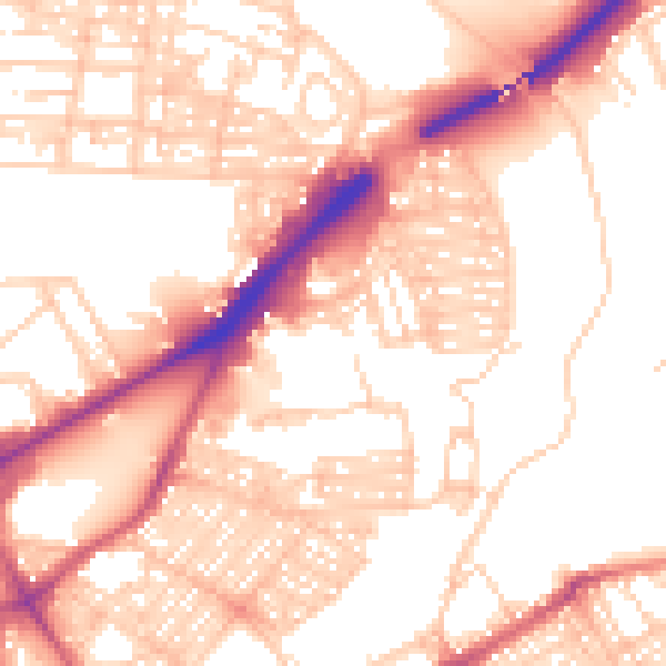
Daytime· 07:00 – 23:00
55.1dB

Night-time· 23:00 – 07:00
44.3dB