2a, Flat 2, Hargrave Place, London, N7 0BP
About 2a
2a is an end-of-terrace house in London (N7 0BP). It has a recorded floor area of 27 m² (around 291 sq ft), construction records dating it to 1900-1929 and council tax band B. The latest certificate (September 2019) shows a C (score 70).
At 27 m² it sits well below the postcode median (54 m² across 12 EPCs), making it one of the more compact homes locally. Across 1995–2021, sale prices on this property compounded at 8.5% per year. On a £-per-square-foot basis, the last sale (£1,118/sq ft) was about 32.3% above the typical sold price in the postcode. Most recent transfer: September 2021 at £325,000. That sale was during the post-pandemic price surge, when transactions cleared materially above pre-2020 trend.
Know exactly what you're buying at 2a
Before you offer, see what the listing won't tell you, the true value, the red flags and the full history.
Valuation
against the asking price
Risks
planning & flood
Sold prices
similar homes nearby
Trends
the local market
Energy performance
2a's carbon output is low for the local stock.
EPC Rating
Planning history
2a has no planning applications on record.
Notable planning nearby
3applications of note in the surrounding area
Sales history & valuation
Price for 2a has grown more than fourfold since the 1995 starting point.
£324,000
Modelled from EPC, postcode comparables and a sale-price growth of 8.5% per year over 26 years.
£325,000
Growth on file: 8.5% per year over 26 years.
Sales timeline
27 September 2021Most recent
£325,000
+20.4%over 4 years10 February 2017
£270,000
+68.8%over 3 years22 February 2013
£160,000
+11.5%over 7 years3 January 2006
£143,500
+29.3%over 2 years5 December 2003
£111,000
+85.0%over 4 years16 June 1999
£59,999
+57.9%over 3 years13 July 1995
£38,000
Median price across the last 5 sales in N7 0BP: £700,000 (2025–2016).
Nearby sales in N7 0BP
Flat 2, 5 Hargrave Place, Camden, London, N7 0BP
Sold Jun 2025
£615,000Flat 5, 5 Hargrave Place, Camden, London, N7 0BP
Sold Jun 2023
£810,000Flat 4, 5 Hargrave Place, Camden, London, N7 0BP
Sold Aug 2016
£460,000Flat 3, 5 Hargrave Place, Camden, London, N7 0BP
Sold Jul 2016
£470,0002 Hargrave Place, Camden, London, N7 0BP
Sold Jun 2014
£350,000
Everything we know about 2a, in one report
What it's really worth, what could be wrong, and the planning, sales and area data in full.
- Am I paying too much?
- Is something wrong with it?
- Is the agent's story true?
- Will it hold its value?

Versus other Hargrave Place homes
On price per m², 2a stands well clear of the street.
Price per m²
£12,037
Street avg £6,993
Floor Area
27 m²
Street avg 63 m²
Habitable Rooms
2 rooms
Street avg 3 rooms
CO₂ Emissions
1.3 t/year
Street avg 2.1 t/year
Similar properties nearby
229a, Flat 12, Camden Road, Islington
N7 0DN
229a, Flat 1, Camden Road, Islington
N7 0DN
229a, Flat 10, Camden Road, Islington
N7 0DN
1a, Flat 1, Campdale Road
N7 0EA
1 3, Flat 8, Pleshey Road
N7 0RA
21 23, Flat 3, Pleshey Road
N7 0RA
12a, Flat 1, Brecknock Road
N7 0DD
1 3, Flat 6, Pleshey Road
N7 0RA
The neighbourhood at a glance
Rail-style transport is unusually close for this postcode.
Crime
12/mo
Rising year-on-year across the wider district.
Nearest stop
0.1 km
Camden Road Brecknock Road — bus stop.
Closest school
0.2 km
Torriano Primary School. 81 schools nearby.
Go deeper on the local area
The full report breaks down crime, transport links, schools and air quality in depth.
Road noise across the postcode
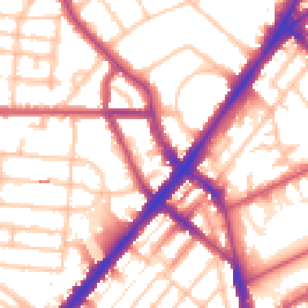
Daytime· 07:00 – 23:00
55.5dB

Night-time· 23:00 – 07:00
45.9dB