16f, Ashburnham Road, Bedford, MK40 1DS
About 16f
16f is a semi-detached house in Bedford (MK40 1DS). It has a recorded floor area of 52 m² (around 560 sq ft), construction records dating it to 2003-2006 and council tax band A. The latest certificate (September 2023) shows a C (score 77), near the top of the C band. The rating has held steady at C across 17 certificates since October 2008. Between certificates, hot-water efficiency went from Poor to Average, lighting went from Very Poor to Very Good and main heating went from Very Poor to Average. Main heating runs on electricity. At 52 m² this is the 15th smallest of 26 units on EPC record in the building, where floor areas span 23–140 m². The building's EPC ratings span E to B across 26 units on file.
Held since April 2007 — that's 19 years off the open market, well above the local norm. That sale landed at the peak of the pre-credit-crunch market, which is a useful reference point when interpreting the price. Today's modelled estimate of £144,000 is 12.9% above the 2007 sale price. One historical planning record sits against the property in 2007.
Everything you need to know about 16f
The true value, the hidden risks and the full sale history, in one report.
Pick your report · from £14.99
One time fee only - money back guarantee

The data behind every report







Energy performance
EPC Rating
Certificate validity
Valid until 26 September 2033
Property Improvements
Changes detected from historical EPC data
Ventilation system changed
More low energy lighting installed
Low energy lighting percentage decreased
Heating controls upgraded for better temperature management
More low energy lighting installed
Hot water efficiency improved
Hot water efficiency decreased
Low energy lighting percentage decreased
Window efficiency improved
More low energy lighting installed
Low energy lighting percentage decreased
More low energy lighting installed
Heating system upgraded to a more efficient system
Hot water efficiency improved
Heating system changed
Hot water efficiency decreased
Window efficiency improved
Heating system upgraded to a more efficient system
Heating controls changed
Hot water efficiency improved
Heating system upgraded to a more efficient system
Window efficiency improved

Get a survey for this property
Level 3 Building Survey
Because the property has no mains gas supply, we believe a Level 3 building survey should be considered.
From £820 · Includes VAT
Planning history
1 application on record at 16f, Ashburnham Road, Bedford, MK40 1DS
- Jan 2007New BuildConditionsOutcome in report
Demolition of existing garage and construction of 16 2-bed flats with parking and ancillary works. Discharge of condition 9 of planning permission 03/02497/FUL - (contamination)
- Documents
- 4 docs on file
- Reference
- 06/03333/AOC
Unlock 16f, Ashburnham Road, Bedford, MK40 1DS's full planning history
You're seeing the shape of it. The report has the substance.
- Every decision — granted, refused or withdrawn (1 on record)
- All 1 application on this property in full, plus 10 notable nearby
- The 4 documents, officer reports & conditions
- What the pattern means for extending or converting here
One time fee only - money back guarantee
Sales history & valuation
The latest sale landed at the peak of the pre-credit-crunch market — a high-water reference point.
£144,000
Modelled from EPC, postcode comparables.
£127,500
Recorded with HM Land Registry.
Sales timeline
1 April 2007Most recent
£127,500
Median price across the last 5 sales in MK40 1DS: £174,000 (2024–2018).
Nearby sales in MK40 1DS
Versus other Ashburnham Road homes
On years held, 16f stands well clear of the street.
Price per m²
£2,452
Street avg £3,779
Floor Area
52 m²
Street avg 57 m²
Habitable Rooms
3 rooms
Street avg 3 rooms
CO₂ Emissions
2.5 t/year
Street avg 2.4 t/year
Everything you need to know about 16f
The true value, the hidden risks and the full sale history, in one report.
Pick your report · from £14.99
One time fee only - money back guarantee
The data behind every report
Similar properties nearby
1 Priory Court
MK40 1JN
1 Beckett Court
MK40 1JP
1 Greyfriars Chambers, Greyfriars
MK40 1HJ
1 Merchant Place, Riverside Square
MK40 1AR
1 Prebend Street
MK40 1QN
1 Dame Alice Street
MK40 1BS
1 Braemar Court, Ashburnham Road
MK40 1DZ
1 Dearne Villas, Ashburnham Road
MK40 1EJ
The neighbourhood at a glance
Rail-style transport is unusually close for this postcode.
Crime
328/mo
Falling year-on-year across the wider district.
Nearest stop
0.1 km
Bedford Rail Station — railway station.
Closest school
0.3 km
Priory Primary School. 30 schools nearby.
Go deeper on the local area
A Local Area report breaks down crime, transport links, schools and air quality in depth.
Road noise across the postcode
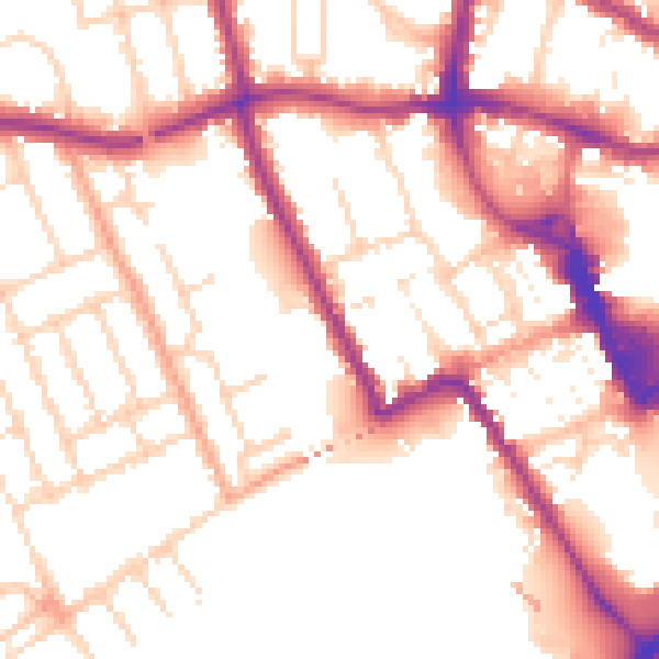
Daytime· 07:00 – 23:00
53.8dB

Night-time· 23:00 – 07:00
44.5dB