3 Beecroft Way, Dunstable, LU6 1ED
About 3 Beecroft Way
3 Beecroft Way is a one-bedroom semi-detached house in Dunstable (LU6 1ED). It has a recorded floor area of 107 m² (around 1152 sq ft), construction records dating it to 1950-1966 and council tax band C. The latest certificate (April 2017) shows a D (score 62), on the cusp of jumping into the C band. The recommended improvements would push it to C (score 76).
Untraded for 26 years, with the last transfer in November 2000. Across 1996–2000, sale prices on this property compounded at 12.8% per year. Today's modelled estimate of £337,000 sits 233.7% above the 2000 sale of £101,000. On a £-per-square-foot basis, the last sale (£88/sq ft) was about 66.8% below the postcode norm. At 107 m² it's 23% larger than the typical home in the postcode (87 m² median across 15 EPCs).
What this property has
Inside
- Bedrooms1
- Dining roomYes
Outside
- Private gardenYes
- ParkingYes
Everything you need to know about 3 Beecroft Way
The true value, the hidden risks and the full sale history, in one report.
30-day money-back guarantee

The data behind every report


Energy performance
EPC Rating
Planning history
3 Beecroft Way has no planning applications on record.
Notable planning nearby
7applications of note in the surrounding area
We flagged 2 things worth checking at 3 Beecroft Way
Independent checks surfaced things a buyer would want to understand before offering. The report explains each one in full, with the underlying data and what to ask.
- Signs of HMO activity in the area
- Larger development activity nearby
30-day money-back guarantee
Sales history & valuation
3 Beecroft Way's modelled value sits at over four times its earliest registered sale price (1996).
£337,000
Modelled from EPC, postcode comparables and a sale-price growth of 12.8% per year over 4 years.
£101,000
Growth on file: 12.8% per year over 4 years.
Sales timeline
3 November 2000Most recent
£101,000
+69.7%over 4 years13 June 1996
£59,500
Median price across the last 5 sales in LU6 1ED: £310,000 (2024–2017).
Nearby sales in LU6 1ED
Versus other Beecroft Way homes
Price per m² for 3 Beecroft Way lags the street by a wide margin.
Price per m²
£944
Street avg £3,392
Floor Area
107 m²
Street avg 89 m²
Habitable Rooms
5 rooms
Street avg 5 rooms
CO₂ Emissions
5.0 t/year
Street avg 4.4 t/year
Everything you need to know about 3 Beecroft Way
The true value, the hidden risks and the full sale history, in one report.
30-day money-back guarantee
The data behind every report
Similar properties nearby
The neighbourhood at a glance
Crime
3/mo
Steady year-on-year across the wider district.
Nearest stop
0.1 km
Loring Road — bus stop.
Closest school
0.4 km
Beecroft Academy. 22 schools nearby.
Go deeper on the local area
The full report breaks down crime, transport links, schools and air quality in depth.
Road noise across the postcode
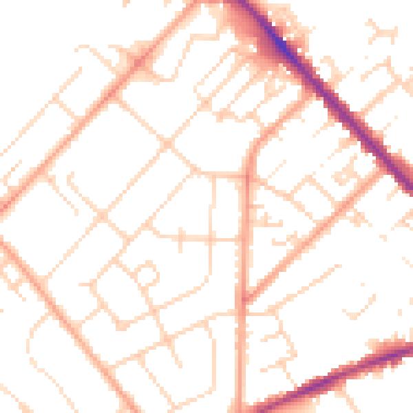
Daytime· 07:00 – 23:00
50.3dB

Night-time· 23:00 – 07:00
39.6dB