12 Roman Street, Leicester, LE3 0BD
About 12 Roman Street
12 Roman Street is a two-bedroom mid-terrace house in Leicester (LE3 0BD). It has a recorded floor area of 85 m² (around 915 sq ft), construction records dating it to before 1900 and council tax band A. The latest certificate (January 2012) shows an E (score 46), well below the UK norm with real room to improve. The latest certificate is from January 2012, so improvements made since then won't be reflected.
Untraded for 21 years, with the last transfer in November 2005. Across the public record there are 4 sales, relatively high churn for a single property. It lags the bulk of the postcode on energy efficiency (less efficient than 82% of similar EPCs). Across 1997–2005, sale prices on this property compounded at 12.4% per year. Today's modelled estimate of £160,000 is 48.8% above the 2005 sale price.
What this property has
Inside
- Bedrooms2
Everything you need to know about 12 Roman Street
The true value, the hidden risks and the full sale history, in one report.
Pick your report · every report is £14.99
One time fee only - money back guarantee

The data behind every report


Energy performance
12 Roman Street's carbon output runs well above what efficient homes in the postcode produce.
EPC Expired
This certificate is over 10 years old and is no longer valid.Expired 23 Jan 2022
EPC Rating
Get a survey for this property
Level 3 Building Survey
Because the property was built before 1919 and has solid (non-cavity) walls, we believe a Level 3 building survey should be considered.
From £820 · Includes VAT
Planning history
12 Roman Street has no planning applications on record.
But the area is active
38 notable applications nearby — larger schemes and conversions that could reshape the street. The report maps them all.
Sales history & valuation
12 Roman Street has more than doubled in price since the earliest registered sale in 1997.
£160,000
Modelled from EPC, postcode comparables and a sale-price growth of 12.4% per year over 9 years.
£107,500
Growth on file: 12.4% per year over 9 years.
Sales timeline
11 November 2005Most recent
£107,500
+16.5%over 3 years1 August 2002
£92,250
+39.8%over 1 year16 February 2001
£66,000
+66.7%over 3 years1 May 1997
£39,600
Median price across the last 5 sales in LE3 0BD: £124,950 (2025–2011).
Nearby sales in LE3 0BD
Versus other Roman Street homes
On epc rating, 12 Roman Street runs well behind the street norm.
Price per m²
£1,265
Street avg £1,391
Floor Area
85 m²
Street avg 87 m²
Habitable Rooms
4 rooms
Street avg 5 rooms
CO₂ Emissions
6.5 t/year
Street avg 4.7 t/year
Everything you need to know about 12 Roman Street
The true value, the hidden risks and the full sale history, in one report.
Pick your report · every report is £14.99
One time fee only - money back guarantee
The data behind every report
Similar properties nearby
1 Celt Street
LE3 0AP
1 Shaftesbury Road
LE3 0QN
1 Ridley Street
LE3 0QL
1 Tyndale Street
LE3 0QQ
1 Bisley Street
LE3 0DA
1 Ashleigh Gardens, Ashleigh Road
LE3 0FJ
1 Frampton Avenue
LE3 0SG
1 Beaconsfield Road
LE3 0FG
The neighbourhood at a glance
Reported crime in the wider district is trending notably upward year-on-year.
Crime
7/mo
Rising year-on-year across the wider district.
Nearest stop
0.1 km
Ruding Road — bus stop.
Closest school
0.2 km
Shaftesbury Junior School. 48 schools nearby.
Go deeper on the local area
A Local Area report breaks down crime, transport links, schools and air quality in depth.
Road noise across the postcode
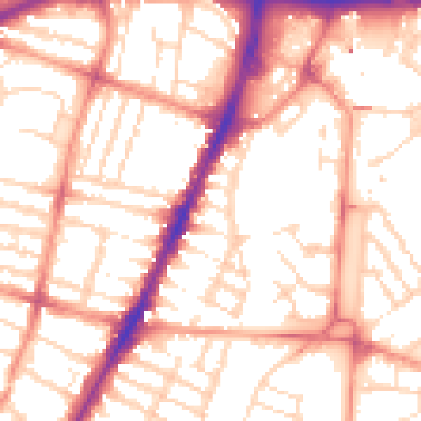
Daytime· 07:00 – 23:00
54.4dB

Night-time· 23:00 – 07:00
42.6dB