Flat 4, 13 Breeze Hill, Bootle, L20 9EY
About Flat 4
Flat 4 is an end-of-terrace house in Bootle (L20 9EY). It has a recorded floor area of 91 m² (around 980 sq ft), construction records dating it to before 1900 and council tax band A. At 91 m² this is the largest unit on EPC record across the building (64–91 m²). The building's EPC ratings span D to C, with this unit at the bottom. On EPC score it ranks last in the building (65 versus a best of 76). The latest certificate (February 2018) shows a D (score 65), on the cusp of jumping into the C band. The recommended improvements would push it to C (score 76).
One planning record on file: new windows approved in 2003. Past consents include new windows, meaningful when judging how the property has evolved. At 91 m² it's 18% smaller than the typical home in the postcode (111 m² median across 11 EPCs).
Everything you need to know about Flat 4
The true value, the hidden risks and the full sale history, in one report.
30-day money-back guarantee

The data behind every report


Energy performance
EPC Rating
Planning history
- Feb 2003RenovationFullIn report
Installation of new windows to existing flats
New Windows- Reference
- S/2003/0011
We flagged 1 thing worth checking at Flat 4
Independent checks surfaced things a buyer would want to understand before offering. The report explains each one in full, with the underlying data and what to ask.
- Signs of HMO activity in the area
30-day money-back guarantee
Sales history & valuation
Flat 4 has no Land Registry sales on file, suggesting it has stayed in the same hands since registration began.
£125,000
Modelled from EPC, postcode comparables.
No sales recorded with HM Land Registry
That can mean the property has never traded since the registry began publishing in 1995, was a new build that hasn't been registered yet, or is held in the same hands long-term.
Median price across the last 3 sales in L20 9EY: £250,000 (2022–2016).
Versus other Breeze Hill homes
Habitable Rooms for Flat 4 runs comfortably ahead of the street norm.
EPC Rating
65 (D)
Street avg 64 (D)
Floor Area
91 m²
Street avg 100 m²
CO₂ Emissions
3.8 t/year
Street avg 4.4 t/year
Habitable Rooms
4 rooms
Street avg 3 rooms
Everything you need to know about Flat 4
The true value, the hidden risks and the full sale history, in one report.
30-day money-back guarantee
The data behind every report
Similar properties nearby
1a, Flat 9, Earl Road
L20 9BD
1a, Flat 4, Earl Road
L20 9BD
1a, Flat 3, Earl Road
L20 9BD
Banbury Court, Flat 5, 260 Gloucester Road
L20 9AP
1a, Flat 7, Earl Road
L20 9BD
1a, Flat 5, Earl Road
L20 9BD
1a, Flat 2, Earl Road
L20 9BD
1a, Flat 6, Earl Road
L20 9BD
The neighbourhood at a glance
Reported crime in the wider district is trending notably upward year-on-year.
Crime
7/mo
Rising year-on-year across the wider district.
Nearest stop
0.1 km
Worcester Road — bus stop.
Closest school
0.1 km
Bedford Primary School. 41 schools nearby.
Go deeper on the local area
The full report breaks down crime, transport links, schools and air quality in depth.
Road noise across the postcode
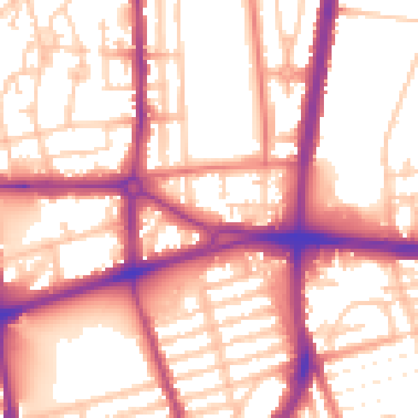
Daytime· 07:00 – 23:00
56.6dB

Night-time· 23:00 – 07:00
47.6dB